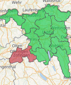
Zofingen District
Zofingen District is a district in the Swiss canton of Aargau. It is located in the southwest corner of the Canton. The seat is Zofingen. The largest municipality in population is Oftringen, the smallest is Wiliberg. It has a population of 71,780 (as of 31 December 2018).[1]
Zofingen District Bezirk Zofingen | |
|---|---|
District | |
| |
| Country | |
| Canton | |
| Capital | Zofingen |
| Area | |
| • Total | 142.01 km2 (54.83 sq mi) |
| Population (2018) | |
| • Total | 71,780 |
| • Density | 510/km2 (1,300/sq mi) |
| Time zone | UTC+1 (CET) |
| • Summer (DST) | UTC+2 (CEST) |
| Municipalities | 17 |
Geography
Bezirk Zofingen has an area, as of 2009, of 141.97 square kilometers (54.81 sq mi). Of this area, 55.93 km2 (21.59 sq mi) or 39.4% is used for agricultural purposes, while 61.82 km2 (23.87 sq mi) or 43.5% is forested. Of the rest of the land, 23.43 km2 (9.05 sq mi) or 16.5% is settled (buildings or roads).[2]
Demographics
Zofingen district has a population (as of December 2018) of 71,780.[1] As of June 2009, 20.4% of the population are foreign nationals.[3]
Economy
In 2000 there were 30,570 workers who lived in the district. Of these, 21,580 or about 70.6% of the residents worked outside the Zofingen district while 16,514 people commuted into the district for work. There were a total of 25,504 jobs (of at least 6 hours per week) in the district.[4]
Religion
From the 2000 census, 15,245 or 26.2% were Roman Catholic, while 31,061 or 53.3% belonged to the Swiss Reformed Church. Of the rest of the population, there were 130 individuals (or about 0.22% of the population) who belonged to the Christian Catholic faith.[2]
Education
Of the school age population (in the 2008/2009 school year), there are 4,351 students attending primary school, there are 1,689 students attending secondary school, there are 1,062 students attending tertiary or university level schooling, and there are 9 students who are seeking a job after school in the municipality.[2]
Municipalities
| Coat of arms | Municipality | Population (31 December 2018)[1] |
Area, km²[5] |
|---|---|---|---|
| Aarburg | 8,197 | 4.42 | |
| Bottenwil | 790 | 5.1 | |
| Brittnau | 3,954 | 13.69 | |
| Kirchleerau | 863 | 4.36 | |
| Kölliken | 4,476 | 8.89 | |
| Moosleerau | 919 | 3.81 | |
| Murgenthal | 2,985 | 18.65 | |
| Oftringen | 13,794 | 12.85 | |
| Reitnau | 1,243 | 5.81 | |
| Rothrist | 9,127 | 11.84 | |
| Safenwil | 3,842 | 5.99 | |
| Staffelbach | 1,281 | 8.94 | |
| Strengelbach | 4,896 | 6.01 | |
| Uerkheim | 1,334 | 7.1 | |
| Vordemwald | 1,955 | 10.13 | |
| Wiliberg | 166 | 1.17 | |
| Zofingen | 11,656 | 11.09 | |
Mergers
The following changes to the district's municipalities have occurred since 2000:
- 2002: Mühlethal merged into Zofingen
- 2019: Attelwil merged into Reitnau
References
- Swiss Federal Statistical Office - STAT-TAB, online database – Ständige und nichtständige Wohnbevölkerung nach institutionellen Gliederungen, Geburtsort und Staatsangehörigkeit (in German) accessed 23 September 2019
- Statistical Department of Canton Aargau - Aargauer Zahlen 2009 (in German) accessed 20 January 2010
- Statistical Department of Canton Aargau -Bereich 01 -Bevölkerung (in German) accessed 20 January 2010
- Statistical Department of Canton Aargau-Bereich 11 Verkehr und Nachrichtenwesen (in German) accessed 21 January 2010
- Swiss Federal Statistical Office-Land Use Statistics 2009 data (in German) accessed 25 March 2010