Zoagli
Zoagli (Ligurian: Zoagi) is a comune (municipality) in the Metropolitan City of Genoa in the Italian region Liguria, located about 30 kilometres (19 mi) southeast of Genoa. Zoagli is a popular destination during all seasons of the year by tourists from all over the world. It is located in the Gulf of Tigullio section of the Italian Riviera, between Chiavari and Rapallo.
Zoagli Zoagi | |
|---|---|
| Comune di Zoagli | |
 Zoagli from the Hills of Sant'Antonio. | |
 Coat of arms | |
Location of Zoagli 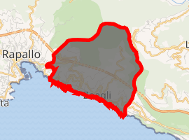
| |
 Zoagli Location of Zoagli in Italy 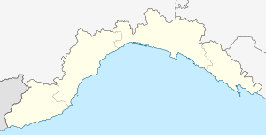 Zoagli Zoagli (Liguria) | |
| Coordinates: 44°20′N 9°16′E | |
| Country | Italy |
| Region | Liguria |
| Metropolitan city | Genoa (GE) |
| Frazioni | Sant’Ambrogio, Semorile, San Pietro di Rovereto |
| Government | |
| • Mayor | Franco Rocca |
| Area | |
| • Total | 7.79 km2 (3.01 sq mi) |
| Elevation | 17 m (56 ft) |
| Population (31 December 2015)[2] | |
| • Total | 2,472 |
| • Density | 320/km2 (820/sq mi) |
| Demonym(s) | Zoagliesi |
| Time zone | UTC+1 (CET) |
| • Summer (DST) | UTC+2 (CEST) |
| Postal code | 16035 |
| Dialing code | 0185 |
| Patron saint | St. Martin of Tours |
| Saint day | November 11 |
| Website | Official website |
The municipality is also known for its silk fabrics exported around the world and its cliff paths (creuze and mule tracks) that run along the Mediterranean Sea connecting Zoagli to its nearby villages: San Pietro di Rovereto, San Pantaleo, Semorile, St. Ambrose, and St. Martin. A bronze sculpture named the Madonna del Mare sits 2.7 metres (9 ft) underwater in front of the promenade in honor of a diving event held each year.
History
Zoagli was probably founded by the Tigulli Ligurian tribe. In Roman times it appears as a center on the Via Aurelia in the Tabula Peutingeriana.
In the Middle Ages it was a fief of the Fieschi family from Lavagna, becoming a possession of the Republic of Genoa in the 13th century. In 1608 it was part of the capitaneato of Rapallo. In 1815, together with Genoa, it was annexed to the Kingdom of Sardinia, following its history.
On 27 December 1943 Zoagli was unexpectedly bombed, and nearly destroyed with many victims among the inhabitants, by the RAF. The target of bombing apparently was the railway bridge, but the railway was totally inactive because it was previously destroyed in several points elsewhere.
References
- "Superficie di Comuni Province e Regioni italiane al 9 ottobre 2011". Istat. Retrieved 16 March 2019.
- All demographics and other statistics: Italian statistical institute Istat.
External links
| Authority control |
|
|---|