Zekharia
Zekharia (Hebrew: זְכַרְיָה) is a moshav in central Israel. Located near Beit Shemesh, it falls under the jurisdiction of Mateh Yehuda Regional Council. In 2018 it had a population of 1,108.
Zekharia | |
|---|---|
 | |
 Zekharia | |
| Coordinates: 31°42′35.28″N 34°56′42.35″E | |
| Country | Israel |
| District | Jerusalem |
| Council | Mateh Yehuda |
| Affiliation | Moshavim Movement |
| Founded | 1950 |
| Founded by | Kurdish Jews |
| Population (2018)[1] | 1,108 |
Geography
The village lies next to the road between Bayt Jibrin and the Jerusalem-Jaffa highway, and has a mean elevation of 268 meters above sea level. It is bordered on its south-east by the Elah Valley, and is situated about 5 kilometres (3.1 mi) south-west of Beit Shemesh. The mountain of Azekah can be seen directly to the south of the village. The villagers obtained their drinking water from two communal wells:- al-Saflani well which was drilled next to Wadi 'Ajjur, and al-Sarara well located north of the village.[2]
History
The nearby town of Beth Zacharia (on a nearby hill) is said to have existed in Roman times.[3] According to legend, the body of the prophet Zachariah was found here in 415 CE and a church and monastery were established in the lower village by the same name.[4] The Madaba Map displays the lower town as the burial site of the prophet Zechariah.[5]
State of Israel
In the 1948 Arab–Israeli War, Az-Zakariyya was the longest lasting Palestinian Arab community in the southern Jerusalem Corridor.[6] The villagers were evicted by the Israelis in three different phases, last eviction was carried out on June 9, 1950, on the orders of David Ben-Gurion, Moshe Sharett and Yosef Weitz, and most ended up on the West Bank.[7]
In 1950 moshav Zekharia was established by Kurdish Jewish immigrants on the village site.[8] During the 1960s, most of the older buildings in the village were destroyed to make room for the new.[9]
In 1992, Walid Khalidi described the remaining structures: "The mosque and a number of houses, some occupied by Jewish residents and others deserted, remain on the site. Large sections of the site itself are covered with wild vegetation. The mosque is in a state of neglect and an Israeli flag is planted on top of the minaret. [..] One of the occupied houses is a two-storey stone structure with a flat roof. Its second story windows have round arches and grillwork. Parts of the surrounding lands are cultivated by Israeli farmers."[8]
Landmarks and culture
The tomb of Zecharia, which has been attributed to both the Hebrew prophet Zecharia and Zechariah, father of John the Baptist, is located on the moshav. The site is mentioned in sources as early as the fourth century, in the writings of Sozomenos, and it appears on the Madaba map. In the 1970s, there was a resurgence of Jewish interest in the site, which became a pilgrimage destination for Jews from Iraq, Iran, Cochin, India and elsewhere, who prayed there and lit candles.[10]
Gallery
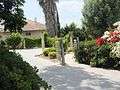 Residence in Moshav Zakariah
 Remains of a minaret and mosque from an earlier period
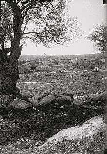 Az-Zakariyya, pre-1926[11]
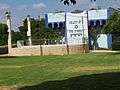 Main synagogue
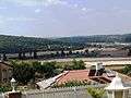 View looking toward the southeast and the Elah Valley
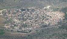
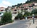 Residential neighborhood on adjacent hilltop
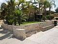 House in Zakariah
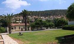
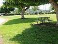 Public park in Zakariah
References
- "Population in the Localities 2018" (XLS). Israel Central Bureau of Statistics. 25 August 2019. Retrieved 26 August 2019.
- Khalidi, 1992, pp. 224–225
- Josephus, Antiquities (Book xii, chapter ix, verse 4)
- Petersen, 2001, p. 320
- See p. 138 in: Tsafrir, Yoram (1986). "The Maps Used by Theodosius: On the Pilgrim Maps of the Holy Land and Jerusalem in the Sixth Century C.E.". Dumbarton Oaks Papers (Trustees for Harvard University). 40: 129–145. doi:10.2307/1291534. JSTOR 1291534.
- Morris, 2004, p. 521
- Mordechai Bar-On, officer in charge of the eviction. Quoted in Morris, 2004, p. 521
- Khalidi, 1992, p. 226
- Arnon Shai (2006). "The Fate of Abandoned Arab Villages in Israel, 1965-1969". History and Memory. 18 (2): 86–106. doi:10.2979/his.2006.18.2.86.
- Sacred Space in Israel and Palestine: Religion and Politics, ed. Marshall J. Breger, Yitzhak Reiter and Leonard Hammer
- Khalidi, 1992, p. 206
Bibliography
- Khalidi, Walid (1992). All That Remains: The Palestinian Villages Occupied and Depopulated by Israel in 1948. Washington D.C.: Institute for Palestine Studies. ISBN 978-0-88728-224-9.
- Morris, Benny (2004). The Birth of the Palestinian Refugee Problem Revisited. Cambridge: Cambridge University Press. ISBN 978-0-521-00967-6.
- Petersen, Andrew (2001). A Gazetteer of Buildings in Muslim Palestine (British Academy Monographs in Archaeology). 1. Oxford University Press. ISBN 978-0-19-727011-0.