Zdzieci Stare
Zdzieci Stare[2][3][4] [ˈzd͡ʑɛt͡ɕi ˈstarɛ] (till December 31, 2000 as at Stare Zdzieci[2][3][4]) is a village in the administrative district of Gmina Połaniec, within Staszów County, Świętokrzyskie Voivodeship, in south-central Poland. It lies approximately 4 kilometres (2 mi) west of Połaniec, 17 km (11 mi) south of Staszów, and 68 km (42 mi) south-east of the regional capital Kielce.[5]
Zdzieci Stare | |
|---|---|
Village | |
 Zdzieci Stare | |
| Coordinates: 50°25′17″N 21°13′11″E | |
| Country | |
| Voivodeship | Świętokrzyskie |
| County | Staszów |
| Gmina | Połaniec |
| Sołectwo | Zdzieci Stare |
| Elevation | 182.6 m (599.1 ft) |
| Population (31 December 2009 at Census)[1] | |
| • Total | |
| Time zone | UTC+1 (CET) |
| • Summer (DST) | UTC+2 (CEST) |
| Postal code | 28-230 |
| Area code(s) | +48 15 |
| Car plates | TSZ |
The village has a population of ![]()
Demography
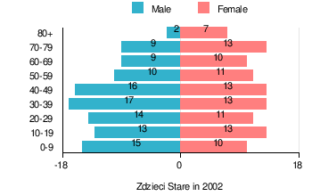
According to the 2002 Poland census, there were 206 people residing in Zdzieci Stare village, of whom 51% were male and 49% were female. In the village, the population was spread out with 21.8% under the age of 18, 37.9% from 18 to 44, 18% from 45 to 64, and 22.3% who were 65 years of age or older.[1]
Table 1. Population level of village in 2002 — by age group[1] SPECIFICATION Measure
unitPOPULATION
(by age group in 2002)TOTAL 0-9 10-19 20-29 30-39 40-49 50-59 60-69 70-79 80 + I. TOTAL person 206 25 26 25 30 29 21 19 22 9 — of which in % 100 12.1 12.6 12.1 14.6 14.1 10.2 9.2 10.7 4.4 1. BY SEX A. Males person 105 15 13 14 17 16 10 9 9 2 — of which in % 51 7.3 6.3 6.8 8.3 7.8 4.9 4.4 4.4 1 B. Females person 101 10 13 11 13 13 11 10 13 7 — of which in % 49 4.9 6.3 5.3 6.3 6.3 5.3 4.9 6.3 3.4
Figure 1. Population pyramid of village in 2002 — by age group and sex[1]
Table 2. Population level of village in 2002 — by sex[1] SPECIFICATION Measure
unitPOPULATION
(by sex in 2002)TOTAL Males Females I. TOTAL person 206 105 101 — of which in % 100 51 49 1. BY AGE GROUP A. At pre-working age person 45 25 20 — of which in % 21.8 12.1 9.7 B. At working age. grand total person 115 64 51 — of which in % 55.8 31 24.8 a. at mobile working age person 78 44 34 — of which in % 37.9 21.4 16.5 b. at non-mobile working age person 37 20 17 — of which in % 18 9.7 8.3 C. At post-working age person 46 16 30 — of which in % 22.3 7.7 14.6
References
- "Local Data Bank (Bank Danych Lokalnych) – Layout by NTS nomenclature (Układ wg klasyfikacji NTS)". demografia.stat.gov.pl: GUS. 10 March 2011.
- Biernacki, Marek (27 November 2000). "Dz.U. z 2000 r. nr 109, poz. 1163" [Journal of the Laws of 2000, No. 109, item 1,163]. Rozporządzenie Ministra Spraw Wewnętrznych i Administracji z dnia 27 listopada 2000 r. w sprawie ustalenia i zmiany urzędowych nazw oraz rodzaju niektórych miejscowości w województwach: dolnośląskim, kujawsko-pomorskim, lubelskim, lubuskim, łódzkim, mazowieckim, podkarpackim, podlaskim, pomorskim, śląskim, świętokrzyskim, warmińsko-mazurskim, wielkopolskim i zachodniopomorskim [Regulation of the Minister of the Internal Affairs and Administration of November 27, 2000 on the establishment and change the official names of localities and the type of settlement in the provinces: Lower Silesia, Kuyavia-Pomerania, Lublin, Lubusz, Łódź, Subcarpathia, Podlaskie, Pomerania, Silesia, Świętokrzyskie, Warmia-Masuria, Greater Poland and West Pomerania] (in Polish). Warsaw, Poland: Ministry of Internal Affairs and Administration. p. 6,202.
- Bielec, Jan (ed.); Szwałek, Stanisława (1982). Wykaz urzędowych nazw miejscowości w Polsce. T. III: P – Ż [List of official names of localities in Poland, Vol. III: P – Ż] (in Polish). Ministry of Administration, Spatial Economy and Environmental Protection (1st ed.). Warsaw, Poland: Central Statistical Office.CS1 maint: extra text: authors list (link)
- "Zdzieci Stare, wieś, gmina Połaniec — obszar wiejski (cz. 1), powiat staszowski, województwo świętokrzyskie" [Zdzieci Stare, village, Połaniec Commune — rural area (part of 1), Staszów County, Świętokrzyskie Province, Poland]. Topographical map prepared in 1:10,000 scale. Aerial and satellite orthophotomap (in Polish). Head Office of Geodesy and Cartography, Poland, Warsaw. 2011. geoportal.gov.pl. Retrieved 27 April 2011.
- "Central Statistical Office (GUS) – TERYT (National Register of Territorial Land Apportionment Journal)" (in Polish). 2008-06-01.
| Town and seat |  | ||||
|---|---|---|---|---|---|
| Parts of town |
| ||||
| Villages |
| ||||
| Part of village |
| ||||
| Colonies |
| ||||
| Farmstead |
| ||||
| Smaller locality | |||||
This article is issued from Wikipedia. The text is licensed under Creative Commons - Attribution - Sharealike. Additional terms may apply for the media files.