Wythall
Wythall is a village and civil parish in the Bromsgrove District, in the north-east corner of the county of Worcestershire, England. Wythall parish borders Solihull and Birmingham, and had a population of 11,377 in the UK census of 2001.[1]
| Wythall | |
|---|---|
 Wythall Location within Worcestershire | |
| Population | 11,377 [1] |
| Civil parish |
|
| District |
|
| Shire county | |
| Region | |
| Country | England |
| Sovereign state | United Kingdom |
| Post town | Birmingham |
| Postcode district | B47 |
| Dialling code | 01564 |
| Police | West Mercia |
| Fire | Hereford and Worcester |
| Ambulance | West Midlands |

Wythall village is around 7 miles south of Birmingham City Centre (a 20-minute train journey from Wythall railway station) along Alcester Road. There are many 18th century buildings on this road including the old post office and school building. The Wythall Institute is still the home of the WI today. The civil parish of Wythall historically includes Drake's Cross, Hollywood and Headley Heath[2][3] and today also includes Major's Green and the Worcestershire part of Walker's Heath. Wythall village itself is generally the area covered by the former Wythall South ward, population 1,400[4] (now the parish wards of Wythall Heath and Grimes Hill) although the Silver Street area is also usually included. The two parish wards additionally include the subsidiary settlements of Inkford and Tanner's Green. The easternmost section of Wythall village, around the railway station, was traditionally referred to as Grimes Hill.
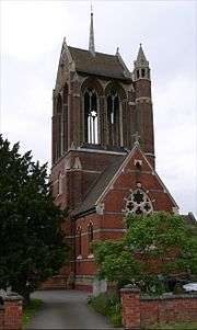
The former St Mary's Anglican church has a roof and stair turret added by W.H. Bidlake.[5]
There are two primary schools within Wythall parish, the Coppice Primary School in Hollywood, now headed by Bill Heptinstall, who started in 2007 and Meadow Green Primary School in Wythall village, now headed by Nathan Jones, who started in September 2009. There was previously a school in Silver Street from circa 1875 to 1992. This catered for all school children in Wythall and the surrounding area, after the initial primary age, until a growing population required more school development. Woodrush High School in Hollywood opened in the 1958 for children aged 11 and over, and Shawhurst Infants School (next door to Woodrush) opened around 1967, leaving what was by now called Silvermead School as a junior school. Meadow Green School opened in the early 1960s to give additional junior and infant provision. During 1991-92 an extension was built on Shawhurst Infants School, and its development became the Coppice Primary School. The Silvermead site was then closed, although many of its buildings have been converted into homes as Silvermead Court. The Coppice Primary School became an Academy in December 2011 and now is the largest primary school in the area and in 2012 started to develop into a three form entry school.
The local secondary school, Woodrush High School, has an Astroturf and playing fields backing on to the Coppice Primary School.
Until 2002 a private school, Innisfree House, existed in Station Road. Its primary purpose was the education of the children of officers of the RAF station (see below), and in the years post-World War II was attended by the young Bruce Chatwin whose parents were living on a smallholding at Umberslade some 3 miles away.
From 1939 to 1959 Wythall was home to a Royal Air Force station, initially housing a barrage balloon facility, and latterly, 1952–57, a Joint Services School of Applied Linguistics, training men from the RN and RAF in Russian military terminology and the use of radios for Signals Intelligence purposes; additionally, Chinese, Czech, German and Polish were taught to small numbers of RAF men. Part of the site is now occupied by the Transport Museum, Chapel Lane, which has a collection of historic buses and battery electric vehicles.
A sawmill, currently named Davies Timber Ltd., has been in operation for over 100 years and was steam powered at some point in its history, and maps from 1838 show a brickyard opposite the site.
References
- Census 2001
- "Worcestershire County Council Historic Parish Maps: Wythall". Archived from the original (prior to transfer of Hawkesley area to Birmingham city) on 6 September 2012. Retrieved 4 August 2012.
- "WythallChurch.net" (Introduction to Parish of Wythall). Retrieved 7 March 2016.
- "Office for National Statistics ward maps and population: Wythall". Retrieved 29 January 2015.
- The Buildings of England: Worcestershire, Nikolaus Pevsner, 1968 p338
External links
| Wikimedia Commons has media related to Wythall. |