Wynyard railway station, Sydney
Wynyard railway station (/ˈwɪnjərd/) is a heritage-listed[1] underground commuter rail station located in the north-west precinct of the Sydney central business district, in New South Wales, Australia. The station opened on 28 February 1932 to coincide with the opening of the Sydney Harbour Bridge.
Wynyard | |||||||||||||||||||||||||||||||||||||||||||
|---|---|---|---|---|---|---|---|---|---|---|---|---|---|---|---|---|---|---|---|---|---|---|---|---|---|---|---|---|---|---|---|---|---|---|---|---|---|---|---|---|---|---|---|
 Wynyard Walk entrance in April 2017 | |||||||||||||||||||||||||||||||||||||||||||
| Location | York Street, Sydney, New South Wales, Australia | ||||||||||||||||||||||||||||||||||||||||||
| Coordinates | 33°51′57″S 151°12′20″E | ||||||||||||||||||||||||||||||||||||||||||
| Owned by | RailCorp | ||||||||||||||||||||||||||||||||||||||||||
| Operated by | Sydney Trains | ||||||||||||||||||||||||||||||||||||||||||
| Line(s) | City Circle | ||||||||||||||||||||||||||||||||||||||||||
| Distance | 2.05 km (1.27 mi) from Central (clockwise) | ||||||||||||||||||||||||||||||||||||||||||
| Platforms | 4 (2 island) | ||||||||||||||||||||||||||||||||||||||||||
| Tracks | 4 | ||||||||||||||||||||||||||||||||||||||||||
| Connections |
| ||||||||||||||||||||||||||||||||||||||||||
| Construction | |||||||||||||||||||||||||||||||||||||||||||
| Structure type | Underground | ||||||||||||||||||||||||||||||||||||||||||
| Platform levels | 2 | ||||||||||||||||||||||||||||||||||||||||||
| Disabled access | Yes | ||||||||||||||||||||||||||||||||||||||||||
| Architect | John Bradfield (designer)[1] | ||||||||||||||||||||||||||||||||||||||||||
| Other information | |||||||||||||||||||||||||||||||||||||||||||
| Status | Staffed | ||||||||||||||||||||||||||||||||||||||||||
| Website | Transport for NSW | ||||||||||||||||||||||||||||||||||||||||||
| History | |||||||||||||||||||||||||||||||||||||||||||
| Opened | 28 February 1932 | ||||||||||||||||||||||||||||||||||||||||||
| Electrified | Yes | ||||||||||||||||||||||||||||||||||||||||||
| Traffic | |||||||||||||||||||||||||||||||||||||||||||
| Passengers (2018) | 173,150 (daily)[2] (Sydney Trains, NSW TrainLink) | ||||||||||||||||||||||||||||||||||||||||||
| Rank | 3 | ||||||||||||||||||||||||||||||||||||||||||
| |||||||||||||||||||||||||||||||||||||||||||
| |||||||||||||||||||||||||||||||||||||||||||
History


The station opened on 28 February 1932.[3] Wynyard was originally constructed with six platforms (the existing four platforms are still numbered from 3 to 6), with platforms 1-4 located on the upper level and platforms 5 and 6 on the lower level. The original intention was that Platforms 1 and 2, located adjacent to platforms 3 and 4, would eventually serve the eastern pair of railway tracks across the Harbour Bridge. In the interim, they were used as a terminus for North Shore tram services on Sydney's tram network, a service that operated over those tracks from the bridge's opening in 1932 until 1958. A feature of these lines was Australia's only underground tram terminus.[1] On 22 January 1956, the lines from platforms 5 and 6 were extended to Circular Quay as part of the City Circle.[1]
Former tram tunnels
In 1968, platforms 1 and 2 were walled off from 3 and 4, and part of the space converted into an underground car park for the Menzies Hotel.[4] The tunnels were accessed from Wynyard Lane where a descending ramp was cut west under Wynyard Park to the disused platforms. The car park used both tunnels north from the former platforms to an exit cut in from Cumberland Street just south of Essex Street.[5] The Wynyard Lane Car Park was closed in October 2016 to make way for the mixed-use Wynyard Place development which would obstruct the entrance ramp to the tunnels.[6]
The remainder of the tunnels north of the car park exit were walled off as were the northern portals on the Harbour Bridge. North of the portals, two additional road lanes were built above the old tramway as part of the Cahill Expressway. The disused tunnels and ramp that formerly connected the station to the eastern tram tracks can still be seen from the pedestrian path along the east side of the bridge, mirroring those still in use to the west of the bridge.
Station configuration


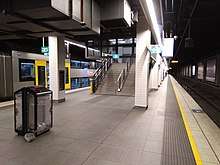
Wynyard station currently has two levels, each with two platforms. The upper level serves the North Shore line, whilst the lower level serves lines traversing the City Circle. Both lines run south under York Street from Wynyard to Town Hall. There is no connection between the rails of these two lines at Wynyard.
The passenger concourse is on an intermediate level between the upper and lower platforms. Wynyard is connected via underground passageways to several surrounding buildings and shopping arcades and is located immediately below Wynyard Park. Direct access via tunnels is possible to George, Hunter and Pitt Streets. Escalators connect the station concourse with York Street (emerging underneath Transport House) and Carrington Street (under Wynyard Park).
Refurbishment
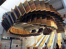
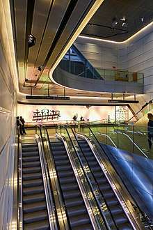
Commencing in 2015, the platforms and concourse were thoroughly refurbished with new flooring and ceilings as well as an extra stairway to platforms 3 and 4 and the addition of more ticket barriers. The four wooden escalators underneath Transport House, which had been operational since the opening of the station, were replaced with modern escalators. Parts of the former escalators were repurposed into a ceiling-mounted artwork titled 'Interloop', which was installed at the York Street entrance to the station concourse.[7][8] The refurbishment was completed in 2018.[9]
Wynyard Place
Above Wynyard Station, Brookfield Properties is building and renovating a series of buildings, into one - Wynyard Place. The George and Carrington Street entrances to Wynyard Station are being greatly expanded to allow for greater access to the railway concourse but also to the buildings above and the new retail levels at street level and below.[10]
Wynyard Walk
The Wynyard Walk is a 180-metre-long (590 ft) pedestrian link and tunnel between Wynyard station and Barangaroo that opened in September 2016,[11] with a Clarence Street entrance that opened in December 2016. Based on a design by architecture firm Woods Bagot,[12] the project combined a new entrance, a pedestrian tunnel, a pedestrian bridge, and a new pedestrian plaza. Wynyard Walk provides direct access via tunnels to Clarence, Kent, and Sussex Streets.[13][14] Wynyard Walk features a huge video screen showcasing digital art.[15]
Platforms and services

| Platform | Line | Stopping pattern | Notes |
| 1 | Former tram platform, not in use | ||
|---|---|---|---|
| 2 | Former tram platform, not in use | ||
| 3 | services to Richmond & Emu Plains | 2 Morning peak services to Blacktown via Central | |
| services to Hornsby via Strathfield & Epping | |||
| 4 | services to Hornsby & Berowra via Gordon | 6 Evening peak NSW TrainLink services to Wyong[16] | |
| services to Gordon | |||
| 5 | services to Homebush, Parramatta & Leppington | ||
| 6 | services to Revesby & Macarthur 2 weekday evening services to Campbelltown |
||
| services to Lidcombe & Liverpool via Bankstown |
Transport links
Wynyard station is served by bus routes operated by Forest Coach Lines, Hillsbus, State Transit, Transdev NSW and Transit Systems.
- 170: weekend service to Manly Wharf via Military Rd & Spit Bridge
- 178: to Cromer Heights
- 243: to Spit Junction
- 244: to Chowder Bay
- 245: to Balmoral
- 246: to Balmoral Heights
- 247: to Mosman Junction (late night services to Taronga Zoo)
- 249: to Beauty Point
Stand B, Carrington St:
- B1: to Mona Vale
Stand C, Carrington St
- 151: to Mona Vale via Manly (late night service)
- 180: to Collaroy Plateau
- 180X: to Collaroy Plateau Express
- 183X: PM peak service to North Narrabeen
- 185X: PM peak service to Mona Vale via Warriewood Valley
- 188: to Avalon (late night service)
- 188X: PM peak service to North Avalon
- 189X: PM peak service to Avalon
- 190X: to Palm Beach Express
Stand D, Carrington St:
- 166X: PM peak service to Allambie Heights
- 176X: PM peak service to Dee Why via North Curl Curl
- 177X: PM peak service to Dee Why via Wingala
- 178: to Cromer Heights
- 178X: PM peak service to Cromer Heights
- 179X: PM peak service to Wheeler Heights
Stand H, York Street:
- 340: to Bondi Junction via Oxford St
- 320: to Mascot via Surry Hills & Botany Road
- 430: to Sydenham via Central Station, City Road and Newtown
Stand J, York St:
- 251: PM peak service to Cope St, Lane Cove West via Freeway
- 253: PM peak service to Riverview
- 293: PM peak service to Busaco Rd, Marsfield via Lane Cove Tunnel & Epping Rd
- 297: PM peak service to Colvin Crescent, Denistone East via Lane Cove Tunnel & North Ryde
- 607X, 610, 610X, 613X, 614X, 615X, 616X, 617X & 618X: QVB
Stand K, York St:
- 594, 594H: QVB
Stand L, York St:
- L70, 270, 271, 273, 274: QVB
Stand N, York St:
- 272: PM peak pre-pay service to North Willoughby
Stand Q, Clarence St:
- 607X: to Rouse Hill Town Centre via Lane Cove Tunnel, M2 & North-West T-way
- 610X: to Rouse Hill Town Centre via Lane Cove Tunnel, M2 & Castle Hill
- 613X: PM peak service to Bella Vista via Lane Cove Tunnel & M2
- 614X: PM peak service to Crestwood via Lane Cove Tunnel, M2 & Winston Hills
- 615X: PM peak and night service to North Kellyville via Lane Cove Tunnel, M2 & Baulkham Hills
- 616X: PM peak and night service to Merriville Kellyville Ridge via Lane Cove Tunnel, Glenwood & Stanhope Gardens
- 617X: PM peak service to Rouse Hill (Adelphi St) via Lane Cove Tunnel, North-West T-Way & Beaumont Hills
- 618X: AM peak service to Norwest Business Park via Lane Cove Tunnel M2 & Baulkham Hills
Stand R, Clarence St:
- 251: PM peak service to Lane Cove West via Gore Hill Freeway
- 252: to Gladesville via Pacific Highway
- 253: PM peak service Riverview via Freeway
- 261: to Lane Cove via Longueville
- 285: peak hour service to Lane Cove Industrial Estate via Freeway & Epping Road
- 288: to Epping station via Gore Hill Freeway, Lane Cove, North Ryde & Macquarie University
- 290: early morning and late night service to Epping via Pacific Highway
- 292: to Marsfield via Freeway, Lane Cove, Mowbray Rd, Fontenoy Rd and Macquarie University
- 293: PM peak service to Busaco Rd, Marsfield via Lane Cove Tunnel & Epping Rd
- 294: 3 AM peak services to Macquarie Centre via Freeway & Talavera Rd
- 297: to Denistone East via Gore Hill Freeway & Lane Cove Tunnel
- 340: to Chatswood station via Willoughby
- 320: to Gore Hill
Stand S, Clarence St:
- 194: to St Ives Chase
- 270: to Terrey Hills via Forest Way
- L70: PM peak limited-stops service to Terrey Hills via Forest Way
- 271: to Belrose, via Davidson
- 273: PM peak service to Killarney Heights
- 274: to Davidson
- 594: to North Turramurra via Eastern Arterial Road
- 594H: to Hornsby via Eastern Arterial Rd
Stand T, Clarence St:
- 168X: PM peak service to Warringah Mall via North Balgowlah
- 169: to Manly via Wakehurst Parkway, Beacon Hill, Dee Why & Pittwater Road
- 169X: PM peak service to Manly via Wakehurst Parkway, Beacon Hill, Dee Why & Pittwater Road
- 171X: PM peak service to Manly via Clontarf & South Balgowlah
- 175X: PM peak service to Brookvale
- 430: to Taronga Zoo
Stand U, Jamison St
- 165X: PM peak service to South Curl Curl
Trackplan

See also
- Architecture of Sydney
- List of Sydney railway stations
- Railways in Sydney
- Rail transport in New South Wales
- Sydney underground railways
References
- "Wynyard Railway Station". New South Wales State Heritage Register. Office of Environment and Heritage.
- NSW Train Stations Barrier Dashboard 2004-2018 Institute for Sustainable futures UTS
- Wynyard Station NSWrail.net
- Saulwick, Jacob (2 July 2011). "Tunnel vision: old tram links could free city streets". Sydney Morning Heralnd. Nine Entertainment Co. Retrieved 19 May 2020.
- "Long tunnel linking Cumberland Street and Wynyard Lane". Reddit. Retrieved 19 May 2020.
- "Community Update - September 2016, Wynyard Place Project" (PDF). Building Wynyard Place. Retrieved 19 May 2020.
- Wong, Luke (7 December 2017). "Wynyard Railway Station escalator sculpture Interloop preserves heritage as time moves on". ABC News. Australian Broadcasting Corporation. Retrieved 7 December 2017.
- "Interloop". Chris Fox. Retrieved 5 January 2019.
- "Wynyard Station Upgrade". Retrieved 23 September 2017.
- A Place Like no Other Brookfield Prperties
- "Wynyard Walk is the ultimate shortcut to Barangaroo" (Press release). Barangaroo Delivery Authority. 20 September 2016. Retrieved 22 February 2017.
- "Woods Bagot made architects for 'revolutionary' Wynyard Walk, Sydney". Architecture & Design. Infolink. 5 November 2012. Retrieved 3 June 2015.
- "Wynyard Walk". Barangaroo Delivery Authority. 20 September 2016. Retrieved 20 September 2016.
- Wynyard Walk Transport for NSW
- Wynscreen
- "Central Coast & Newcastle line timetable". Transport for NSW.
External links
![]()
- Wynyard Station at Transport for New South Wales (Archived 10 June 2019)
- Wynyard Station Map Transport for NSW