Wramplingham
Wramplingham is a village and civil parish in the English county of Norfolk. It is situated on the River Tiffey some 4 miles (6.4 km) north of Wymondham and 7 miles (11 km) west of Norwich. The civil parish has an area of 3.47 square kilometres and in 2001 had a population of 110 in 44 households, increasing to a population of 115 in 51 households at the 2011 Census. For the purposes of local government, the parish falls within the district of South Norfolk.
| Wramplingham | |
|---|---|
 Wramplingham Location within Norfolk | |
| Area | 3.47 km2 (1.34 sq mi) |
| Population | 115 (2011)[1] |
| • Density | 33/km2 (85/sq mi) |
| OS grid reference | TG112063 |
| Civil parish |
|
| District | |
| Shire county | |
| Region | |
| Country | England |
| Sovereign state | United Kingdom |
| Post town | WYMONDHAM |
| Postcode district | NR18 |
| Police | Norfolk |
| Fire | Norfolk |
| Ambulance | East of England |
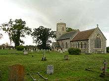
The church of Wramplingham St Peter and St Paul is one of 124 existing round-tower churches in Norfolk. The round tower at Wramplingham is thought to have originally been an Anglo-Saxon watch tower.
Wramplingham Mill was a three-storey weatherboarded corn mill, demolished in 1945.
References
- "Civil Parish population 2011". Neighbourhood Statistics. Office for National Statistics. Retrieved 15 August 2016.
- ^ Ordnance Survey (1999). OS Explorer Map 237 - Norwich. ISBN 0-319-21868-6.
- ^ Office for National Statistics & Norfolk County Council (2001). Census population and household counts for unparished urban areas and all parishes. Retrieved December 2, 2005.
External links
![]()
- Map sources for Wramplingham.
- Information from Genuki Norfolk on Wramplingham.
- Website with photos of Wramplingham St Peter and St Paul, a round-tower church
- Wramplingham Mill
- Barford & Wramplingham Village Hall Website for the two villages with regularly updated event information.