Woodstock Parish, New Brunswick
Woodstock is a Canadian parish in Carleton County, New Brunswick.[2]
Woodstock | |
|---|---|
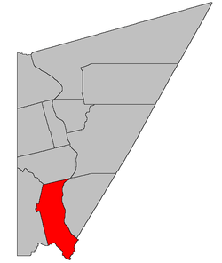 Location within Carleton County, New Brunswick | |
| Coordinates: 46.06°N 67.6°W | |
| Country | |
| Province | |
| County | Carleton |
| Established | 1786 |
| Area | |
| • Land | 195.62 km2 (75.53 sq mi) |
| Population (2016)[1] | |
| • Total | 2,220 |
| • Density | 11.3/km2 (29/sq mi) |
| • Pop 2011-2016 | |
| • Dwellings | 930 |
| Time zone | UTC-4 (AST) |
| • Summer (DST) | UTC-3 (ADT) |
Its population in the 2016 Census was 2,220.[1]
Delineation
Woodstock Parish is defined in the Territorial Division Act[3] as being bounded:
- South by the boundary of the County; east by the Saint John River; north by the lower line of lot number one, granted to Caleb Phillips, and its prolongation westerly; and west by the rear or western line of the second tier of lots west of the Saint John River to Eel River, including all the islands in front.
Communities
Parish population total does not include incorporated municipalities (in bold):
|
|
|
Demographics
Population
|
LanguageMother tongue (2016)[1]
|
See also
References
- "Census Profile, 2016 Census: Woodstock, Parish [Census subdivision], New Brunswick". Statistics Canada. Retrieved September 7, 2019.
- New Brunswick Provincial Archives - Woodstock Parish
- "Territorial Division Act (R.S.N.B. 1973, c. T-3)". Government of New Brunswick website. Retrieved 30 August 2016.
- Statistics Canada: 1951, 1996, 2001, 2006 census
- 2011 Statistics Canada Census Profile: Woodstock Parish, New Brunswick
Places adjacent to Woodstock Parish, New Brunswick | ||||||||||
|---|---|---|---|---|---|---|---|---|---|---|
| ||||||||||
| Subdivisions |
|
|---|---|
| Cities | |
| Counties | |
| |
This article is issued from Wikipedia. The text is licensed under Creative Commons - Attribution - Sharealike. Additional terms may apply for the media files.