Wohratal
Wohratal is a community in Marburg-Biedenkopf district in Hesse, Germany.
Wohratal | |
|---|---|
 Coat of arms | |
Location of Wohratal within Marburg-Biedenkopf district 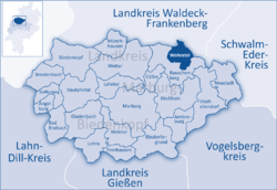 | |
 Wohratal  Wohratal | |
| Coordinates: 50°56′N 08°56′E | |
| Country | Germany |
| State | Hesse |
| Admin. region | Gießen |
| District | Marburg-Biedenkopf |
| Government | |
| • Mayor | Heiko Dawedeit[1] |
| Area | |
| • Total | 30.66 km2 (11.84 sq mi) |
| Elevation | 240 m (790 ft) |
| Population (2018-12-31)[2] | |
| • Total | 2,192 |
| • Density | 71/km2 (190/sq mi) |
| Time zone | CET/CEST (UTC+1/+2) |
| Postal codes | 35288 |
| Dialling codes | 06453 und 06425 |
| Vehicle registration | MR |
| Website | www.wohratal.de |
Geography
Wohratal lies between the Kellerwald (forest) in the east and the Burgwald, a low mountain range, in the west, on the river Wohra.
Among the bigger neighbouring centres are the towns of Frankenberg an der Eder to the northwest and Kirchhain to the south.
Neighbouring municipalities
In the north, Wohratal borders on the towns of Rosenthal and Gemünden, both in Waldeck-Frankenberg district, in the east on the community of Gilserberg in Schwalm-Eder district, and on Rauschenberg, also in Marburg-Biedenkopf district, in the south and west.
Constituent communities
The community consists of four centres: Wohra, Hertingshausen, Halsdorf and Langendorf.
Politics
As of the municipal elections on 26 March 2006, the seats on Wohratal's council are apportioned thus:
- SPD 7 seats
- CDU 5 seats
- Greens 2 seats
- UWG (citizens' coalition) 1 seat
References
- https://wohratal.de/neubaugebiete
- "Bevölkerungsstand am 31.12.2018". Hessisches Statistisches Landesamt (in German). July 2019.
External links
Towns and municipalities in the district of Marburg-Biedenkopf | ||
|---|---|---|
Wappen des Landkreises Marburg-Biedenkopf | ||
| Authority control |
|
|---|