Waldeck-Frankenberg
Waldeck-Frankenberg is a Kreis (district) in the north of Hesse, Germany. Neighbouring districts are Höxter, Kassel, Schwalm-Eder, Marburg-Biedenkopf, Siegen-Wittgenstein, Hochsauerland.
Waldeck-Frankenberg | |
|---|---|
 Coat of arms | |

| |
| Country | Germany |
| State | Hesse |
| Adm. region | Kassel |
| Founded | 1974-01-01 |
| Capital | Korbach |
| Area | |
| • Total | 1,848.58 km2 (713.74 sq mi) |
| Population (31 December 2018)[1] | |
| • Total | 156,953 |
| • Density | 85/km2 (220/sq mi) |
| Time zone | UTC+01:00 (CET) |
| • Summer (DST) | UTC+02:00 (CEST) |
| Vehicle registration | KB |
| Website | landkreis-waldeck-frankenberg.de |
History
The district was created in 1972 by merging the two districts of Frankenberg and Waldeck. Most of the area of the district was previously part of the Freistaat Waldeck, the successor of the principality of Waldeck.
Geography
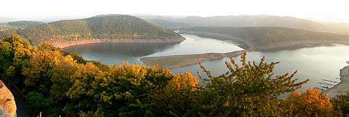
The district is located in the mountains of the Sauerland, with the highest elevation in the district of 843 m. With 1,848.58 square kilometers, it's the largest district in Hessen.
Four artificial lakes created by dams are in the district, the biggest is the Edersee, which covers an area of 12.00 km². The Eder is also the main river in the district; the Diemel in the north is a smaller river.
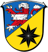
Coat of arms
- Blason
- “Per bend sinister Azure a lion rampant issuant per fess Argent and Gules and Or a star with eight rays Sable.”
The coat of arms shows the lion of Hesse in chief. The eight-fold star in base is taken from the coat of arms of the counts and princes of Waldeck, and was also the coat of arms of the former district of Waldeck.
Towns and municipalities

| Towns | Municipalities |
|---|---|
|
References
- "Bevölkerungsstand am 31.12.2018". Hessisches Statistisches Landesamt (in German). July 2019.
External links
![]()
- Official website (German)
| Authority control |
|
|---|