Winfall, North Carolina
Winfall is a town in Perquimans County, North Carolina, United States. The population was 594 at the 2010 census. It is part of the Elizabeth City, North Carolina Micropolitan Statistical Area.

Winfall, North Carolina | |
|---|---|
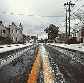 Main Street in Winfall after the 2015 Valentine's Day blizzard | |
| Motto(s): "Forward With Integrity" | |
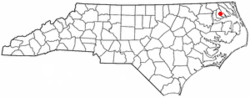 Location of Winfall, North Carolina | |
| Coordinates: 36°12′52″N 76°27′24″W | |
| Country | United States |
| State | North Carolina |
| County | Perquimans |
| Incorporated | 1887 |
| Government | |
| • Mayor | Frederick Yates |
| Area | |
| • Total | 2.1 sq mi (5.6 km2) |
| • Land | 2.1 sq mi (5.5 km2) |
| • Water | 0.0 sq mi (0.0 km2) |
| Elevation | 13 ft (4 m) |
| Population (2010) | |
| • Total | 594 |
| • Estimate (2018)[1] | 600 |
| • Density | 280/sq mi (110/km2) |
| Time zone | UTC-5 (Eastern (EST)) |
| • Summer (DST) | UTC-4 (EDT) |
| ZIP code | 27985 |
| Area code(s) | 252 |
| FIPS code | 37-74720[2] |
| GNIS feature ID | 1023283[3] |
History
The Winfall Historic District was listed on the National Register of Historic Places in 2003.[4]
Geography
Winfall is located at 36°12′52″N 76°27′24″W (36.214551, -76.456758).[5]
Winfall (along with Hertford) is considered to be on the southwestern-most fringe of Hampton Roads Metropolitan Area, and many local residents commute frequently to and from the Seven Cities region for work, shopping, and leisure.[6]
According to the United States Census Bureau, the town has a total area of 2.2 square miles (5.7 km2), of which, 2.1 square miles (5.4 km2) of it is land and 0.47% is water. It is located strategically upon the Perquimans River.
Demographics
| Historical population | |||
|---|---|---|---|
| Census | Pop. | %± | |
| 1900 | 222 | — | |
| 1910 | 289 | 30.2% | |
| 1920 | 288 | −0.3% | |
| 1930 | 426 | 47.9% | |
| 1940 | 160 | −62.4% | |
| 1950 | 421 | 163.1% | |
| 1960 | 269 | −36.1% | |
| 1970 | 581 | 116.0% | |
| 1980 | 634 | 9.1% | |
| 1990 | 501 | −21.0% | |
| 2000 | 554 | 10.6% | |
| 2010 | 594 | 7.2% | |
| Est. 2018 | 600 | [1] | 1.0% |
| U.S. Decennial Census[7] | |||
As of the census[2] of 2000, there were 554 people, 234 households, and 153 families residing in the town. The population density was 259.0 people per square mile (100.0/km²). There were 276 housing units at an average density of 129.0 per square mile (49.8/km²). The racial makeup of the town was 61.73% White, 37.73% African American, and 0.54% from two or more races. Hispanic or Latino of any race were 0.54% of the population.
There were 234 households out of which 25.6% had children under the age of 18 living with them, 50.0% were married couples living together, 11.1% had a female householder with no husband present, and 34.2% were non-families. 30.3% of all households were made up of individuals and 17.1% had someone living alone who was 65 years of age or older. The average household size was 2.37 and the average family size was 2.94.
In the town, the population was spread out with 22.9% under the age of 18, 7.0% from 18 to 24, 24.7% from 25 to 44, 22.9% from 45 to 64, and 22.4% who were 65 years of age or older. The median age was 42 years. For every 100 females, there were 93.7 males. For every 100 females age 18 and over, there were 88.1 males.
The median income for a household in the town was $27,386, and the median income for a family was $30,417. Males had a median income of $27,083 versus $17,875 for females. The per capita income for the town was $13,587. About 12.6% of families and 17.8% of the population were below the poverty line, including 25.4% of those under age 18 and 18.1% of those age 65 or over.
References
- "Population and Housing Unit Estimates". Retrieved March 14, 2020.
- "U.S. Census website". United States Census Bureau. Retrieved 2008-01-31.
- "US Board on Geographic Names". United States Geological Survey. 2007-10-25. Retrieved 2008-01-31.
- "National Register Information System". National Register of Historic Places. National Park Service. July 9, 2010.
- "US Gazetteer files: 2010, 2000, and 1990". United States Census Bureau. 2011-02-12. Retrieved 2011-04-23.
- "Region Redefined to Include Gates County, NC". Hampton Roads Planning District Commission. Retrieved 2016-04-09.
- "Census of Population and Housing". Census.gov. Retrieved June 4, 2015.
External links
Municipalities and communities of Perquimans County, North Carolina, United States | ||
|---|---|---|
| Towns |  | |
| Unincorporated communities | ||
| Authority control |
|
|---|