Willamette Valley AVA
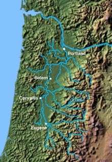
The Willamette Valley AVA (/wɪˈlæmɪt/ wi-LAM-it), is an American Viticultural Area which lies in the Willamette Valley of Oregon. The AVA is the wine growing region which encompasses the drainage basin of the Willamette River. It stretches from the Columbia River in the north to just south of Eugene in the south, where the Willamette Valley ends; and from the Oregon Coast Range in the west to the Cascade Mountains in the east. At 5,360 square miles (13,900 km2), it is the largest AVA in the state, and contains most of the state's wineries; approximately 200 as of 2006.
| Wine region | |
 Willamette Valley | |
| Type | American Viticultural Area |
|---|---|
| Year established | 1984[1] |
| Years of wine industry | 1965–present |
| Country | United States |
| Part of | Oregon |
| Sub-regions | Chehalem Mountains AVA, Dundee Hills AVA, Eola-Amity Hills AVA, McMinnville AVA, Ribbon Ridge AVA, Van Duzer Corridor AVA, Yamhill-Carlton District AVA |
| Climate region | Maritime |
| Soil conditions | Volcanic origin and weathered sedimentary loam[2] |
| Total area | 5,360 square miles (3,430,400 acres)[3] |
| Grapes produced | Auxerrois, Cabernet Franc, Cabernet Sauvignon, Cascade, Chardonnay, Dolcetto, Gamay noir, Gewurztraminer, Malbec, Marechal Foch, Melon, Merlot, Müller-Thurgau, Muscat Canelli, Muscat Ottonel, Pinot blanc, Pinot gris, Pinot noir, Riesling, Sauvignon blanc, Syrah, Tocai Friulano, Viognier[2] |
| No. of wineries | 500 |
The boundaries of the Willamette Valley AVA were established in 1984, and since then seven new, smaller AVAs have been created within the northern portion of Willamette Valley AVA. The Willamette Valley has a cool, moist climate, and is recognized worldwide for its Pinot noir.[2]
Although this distinction is not officially recognized, many wine connoisseurs further divide the Willamette Valley into northern and southern regions, the dividing line being the approximate latitude of Salem (approximately 45° north latitude).[4]
Climate
The climate of Willamette Valley is mild year-round. Winters are typically cool and wet, summers are dry and warm; heat above 90 °F (32 °C) only occurs 5 to 15 days per year, and the temperature drops below 0 °F (−18 °C) once every 25 years. Most rainfall occurs in the late autumn, winter, and early spring, when temperatures are the coldest. The valley gets relatively little snow (5 inches (13 cm) to 10 inches (25 cm)) per year.[5] The hardiness zone is mostly 8b.[6]
Not all portions of the Willamette Valley are suitable for vineyards, however, and the largest concentration of wineries is found west of the Willamette River, on the leeward slopes of the Coast Range, or among the numerous river and stream valleys created by Willamette River tributaries. By far, the largest concentration of wineries is in Yamhill County.[7]
Sub-appellations
There are seven American Viticultural Areas within the Willamette Valley AVA. These smaller AVAs recognize regions within the larger Willamette Valley AVA that have distinctive climate, soil, elevation, or other physical features that make them noteworthy for wine production.
Chehalem Mountains AVA
The Chehalem Mountains AVA, established in 2006, stretches 20 miles (32 km) from Wilsonville in the southeast to Forest Grove in the northwest. The Chehalem Mountains includes Ribbon Ridge, Parrett Mountain, and Bald Peak. The petition process for the creation of the AVA began in 2001 and was led by David Adelsheim of Adelsheim Vineyard.[8]
Dundee Hills AVA
The Dundee Hills AVA in the hills north and west of Dundee.[9] The area is 6,940 acres (28.1 km²) in total size, with 1,300 acres (530 ha) planted with grapes. Over 25 wineries and independent vineyards in this region produce over 44,000 cases of wine. The area is particularly noted for its Pinot noir; several wineries in the AVA have won international recognition for their wines.[10]
Eola-Amity Hills AVA
The Eola-Amity Hills AVA stretches from the town of Amity in the north to Salem in the south. The hills cover an area west of the Willamette River approximately 15 miles (24 km) long by 6 miles (10 km) wide. The Eola-Amity Hills area benefits from steady winds off the Pacific Ocean that reach the Willamette Valley through the Van Duzer corridor, a gap in the Oregon Coast Range, moderating the summer temperatures. The name Eola is a tribute to the windy conditions in the area, and is derived from Aeolus, the Greek god of wind.[11]
McMinnville AVA
The McMinnville AVA near McMinnville was established in 2005, in the hills to the southwest of McMinnville, roughly running from McMinnville to Sheridan. The AVA includes 14 wineries and 523 acres (2.1 km2) of vineyards, and includes lands with elevations ranging from 200 to 1,000 feet (300 m).[12][13]
Ribbon Ridge AVA
The Ribbon Ridge AVA, between Newberg and Gaston, is a ridge containing uplift of ocean sediment. It lies at 45° 21' N, 123° 04' W, at the northwest end of the Chehalem Mountains. The name originates in the 19th century. The ridge is approximately 0.25 miles (0.40 km) wide and 3.50 miles (5.63 km) long, and is 3,350 acres (14 km2) in area, with 500 acres (2.0 km2) planted on 20 vineyards.[13] It is estimated that between 1,000 acres (4 km2) and 1,400 acres (6 km2) in the region is suitable for planting.[14][15]
Van Duzer Corridor AVA
The Van Duzer Corridor AVA is located just west of the Eola-Amity Hills AVA covering approximately 59,871 acres. The Van Duzer wind AVA is known low elevations and gently rolling hills, cool breezes from the Pacific Ocean, and soils which are primarily uplifted marine sedimentary loams and silts with alluvial overlay. The AVA was established in 2019[16].
Yamhill-Carlton District AVA
The Yamhill-Carlton District AVA in the area surrounding the towns of Yamhill and Carlton. Only grapes grown in vineyards with elevations ranging from 200 feet (100 m) to 1,000 feet (300 m) may be used to produce wines that bear the appellation name on their labels. The AVA includes over 1,200 acres (5 km2) of vineyard, and the region is in the rain shadow of the 3,500 feet (1,100 m) Oregon Coast Range, a short distance to the west. The AVA was established in 2005.[13][17][18]
References
- "§ 9.90 Willamette Valley" (Title 27: Alcohol, Tobacco and Firearms; Part 9— American Viticultural Areas; Subpart C— Approved American Viticultural Areas). Code of Federal Regulations (e-CFR). Retrieved January 29, 2008.
- "Willamette Valley (AVA): Appellation Profile". Appellation America. 2007. Archived from the original on March 16, 2009. Retrieved January 29, 2008.
- "Expansion of the Willamette Valley Viticultural Area" (27 CFR 9 81 FR 11110). Federal Register. Alcohol and Tobacco Tax and Trade Bureau. March 3, 2016. pp. 11110–11113.
- "Salem, OR, USA". LatLong.net.
- "Oregon Climate Zone Summary: Zone 2 - The Willamette Valley". Oregon State University. Archived from the original on February 2, 2008.
- "Plant Hardiness Zone". United States Department of Agriculture.
- "North Willamette Valley Wineries Overview Map" (Oregon's Willamette Valley Wine Country). Wines Northwest.
- "Chehalem Mountains Becomes Oregon's Fifteenth American Viticultural Area". Wines Northwest. December 27, 2006. Archived from the original on May 17, 2008.
- "Proposed Dundee Hills Viticultural Area (2002R-218P)". Federal Register. Alcohol and Tobacco Tax and Trade Bureau, United States Department of the Treasury. August 15, 2003.
- "Dundee Hills Winegrowers Association Press Kit". Archived from the original on April 12, 2009.
- Purdue, Andy (June 15, 2006). "Introducing the Eola-Amity Hills". Wine Press Northwest. Archived from the original on March 3, 2008. Retrieved January 29, 2009.
- "Establishment of the McMinnville Viticultural Area (2002R-217P)". Federal Register. Alcohol and Tobacco Tax and Trade Bureau (TTB), Treasury. January 18, 2005.
- "Willamette Valley AVAs". Willamette Valley Wineries. Archived from the original on August 15, 2006.
- "Ribbon Ridge AVA". Ribbon Ridge Vineyard. Archived from the original on January 5, 2006.
- "Establishment of the Ribbon Ridge Viticultural Area (2002R-215P)". Federal Register. Alcohol and Tobacco Tax and Trade Bureau (TTB), Treasury. June 1, 2005.
- "Establishment of the Van Duzer Corridor Viticultural Area and Clarification of the Eola-Amity Hills Viticultural Area Boundary Description". Federal Register. Alcohol and Tobacco Tax and Trade Bureau, Treasury. December 14, 2018.
- "Establishment of the Yamhill-Carlton District Viticultural Area (2002R-216P)". Federal Register. Alcohol and Tobacco Tax and Trade Bureau, Treasury. October 7, 2003.
- "Yamhill Carlton District (AVA): Appellation Profile". Appellation America. Archived from the original on September 8, 2013.