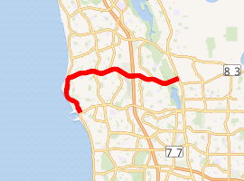
Whitfords Avenue
Whitfords Avenue is an arterial east-west road located in the northern suburbs of Perth, Western Australia. It took its name from the Whitford Satellite City development through which it was built in the 1970s, which was later split into the suburbs of Hillarys, Padbury, Kallaroo and Craigie. In 1985, the part of West Coast Highway between Hepburn Avenue and Whitfords Avenue was renamed to Whitfords Avenue.
Whitfords Avenue | |
|---|---|
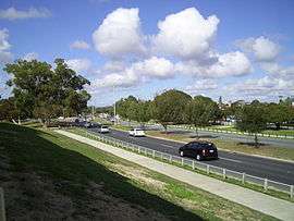 | |
View eastbound approaching Marmion Avenue | |
| |
| General information | |
| Type | Road |
| Length | 10 km (6.2 mi) |
| Opened | 1970s |
| Route number(s) | |
| Tourist routes | |
| Major junctions | |
| West end | |
| |
| East end | |
| Location(s) | |
| Major suburbs | Kallaroo, Craigie, Padbury, Woodvale, Kingsley |
Apart from the Westfield Whitford City shopping centre, Whitfords Avenue also passes through two open spaces, Craigie Open Space near Mitchell Freeway, and Yellagonga Regional Park near Wanneroo Road.
It is allocated State Route 83 east of Marmion Avenue, and Tourist Drive 204 between West Coast Drive and Northshore Drive.[1]
It is a four lane dual carriageway east of Northshore Drive, as well as between Hepburn Avenue and Northside Drive/Tenerife Boulevard, and is a two lane single carriageway in the stretch between.
Major intersections


- Eddystone Avenue, Craigie
- Gibson Avenue, Padbury

- Kingsley Drive, Kingsley
- Trappers Drive, Woodvale
- Barridale Drive, Kingsley
- Moolanda Boulevard, Kingsley


See also
![]()
References
- Distance book (12 ed.). Main Roads Western Australia. 2012. pp. 4–5. ISBN 0 7309 7657 2. Retrieved 8 October 2012.
| |||||
| National Highways | |||||
| National Routes | |||||
| State Routes | |||||
| Tourist Drives |
| ||||