Rapperswil-Jona
Rapperswil-Jona is a municipality in the Wahlkreis (constituency) of See-Gaster in the canton of St. Gallen in Switzerland. Besides Rapperswil and Jona, which were separate municipalities until 2006, the municipality includes Bollingen, Busskirch, Curtiberg, Kempraten-Lenggis, Wagen, and Wurmsbach.
Rapperswil-Jona | |
|---|---|
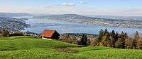
 Rapperswil-Jona as seen from Kempraten-Lenggis, Jona to the left, Rapperswil and Seedamm to the right, Obersee (upper Lake Zürich) and Lachen (SZ) in the background (March 2010) | |
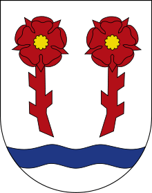 Coat of arms | |
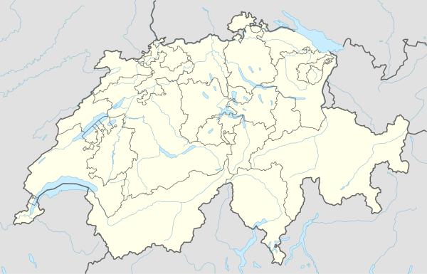
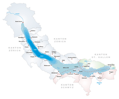
Location of Rapperswil-Jona 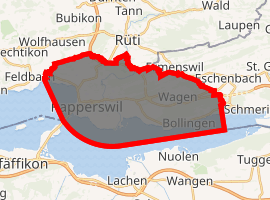
| |
 Rapperswil-Jona Rapperswil-Jona | |
| Coordinates: 47°13′N 8°49′E | |
| Country | Switzerland |
| Canton | St. Gallen |
| District | See-Gaster |
| Government | |
| • Executive | Stadtrat with 7 members |
| • Mayor | Stadtpräsident (list) Martin Stoeckling CVP/PDC (as of February 2016) |
| Area | |
| • Total | 22.17 km2 (8.56 sq mi) |
| Elevation | 409 m (1,342 ft) |
| Highest elevation (Eggwald, Wagen) | 544 m (1,785 ft) |
| Lowest elevation (Busskirch) | 407 m (1,335 ft) |
| Population (2018-12-31)[2] | |
| • Total | 26,995 |
| • Density | 1,200/km2 (3,200/sq mi) |
| Postal code | 8640 |
| SFOS number | 3340 |
| Localities | Rapperswil, Jona, Bollingen, Busskirch, Curtiberg, Kempraten-Lenggis, Wagen, Wurmsbach |
| Surrounded by | Altendorf (SZ), Bubikon (ZH), Eschenbach, Freienbach (SZ), Hombrechtikon (ZH), Lachen (SZ), Rüti (ZH), Schmerikon, Tuggen (SZ), Wangen (SZ) |
| Twin towns | Aalborg (Denmark), Bagno di Romagna (Italy) |
| Website | www SFSO statistics |
The official language of Rapperswil is (the Swiss variety of Standard) German, but the main spoken language is the local variant of the Alemannic Swiss German dialect.
Today


On January 1, 2007, the municipalities of Rapperswil and Jona merged to form a new political entity.[3] After the merger Rapperswil-Jona had a population of 25,777 (17,799 from Jona and 7,601 from Rapperswil). This makes it the second largest town in the canton after the capital St. Gallen itself. On 31 December 2018 the population was 26,999.[4]
Rapperswil-Jona is one of the most significant traffic junctions in the region, and Rapperswil railway station is a nodal point for the Swiss Federal Railways, Südostbahn and S-Bahn Zürich lines. Zürichsee-Schifffahrtsgesellschaft (commonly abbreviated to ZSG) operates passenger vessels on the Lake Zürich, connecting surrounding towns between Zürich-Bürkliplatz and Rapperswil. The Seedamm, a dam across Lake Zürich, links Rapperswil with Hurden (SZ) on the other side of the lake. This connection has been part of old pilgrimage routes. From early centuries, a wooden footbridge led across Lake Zürich. At a later stage, the bridge was replaced by a stone dam. In 2001, a new wooden footbridge was opened alongside the dam for the first 840 meters of the crossing. It was built in the same place as the original bridge and links Rapperswil with the nearby bridge chapel (Heilig Hüsli) built in 1551.
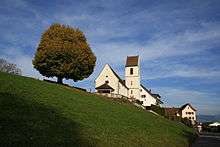
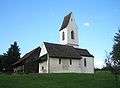
The main sights are concentrated in the centre of Rapperswil and can be seen while strolling through the medieval alleys. The main sights of Rapperswil are its roses, the castle, the reconstructed wooden bridge to Hurden with its bridge chapel, and a Capuchin monastery. There are also a number of churches, chapels, and the nearby Wurmsbach Abbey. In the surroundings of the town there are a number of churches. St. John's Church in Rapperswil was built around 1220 and became Rapperswil's parish church in 1253, the Chapel St. Ursula in the village of Kempraten was built around 885. The St. Dionysius Chapel, dedicated to Denis, the first bishop of Paris, was reconstructed in 1493 and attracts pilgrims. The nunnery at Wurmsbach (Wurmsbach Abbey) was established in 1259 and today houses an institute for girls, and St. Martin Busskirch is the former parish church of Rapperswil.
Bollingen is known for the "Tower" built there by Carl Jung. Kempraten is one of the most important archeological sites in the canton of St. Gallen and is located at the eastern parts of the upper Lake Zürich. Jona river is flowing through the municipality in the upper Lake Zürich. In 2006 Rapperswill-Jona hosted the World Orienteering Championships.
History
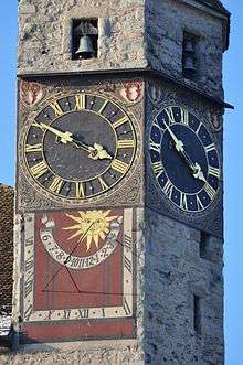
Settlements in the region of Rapperswil date back at least 5000 years. Atop the Lindenhof hill overlooking a former small village (Endingen), Rapperswil Castle was built around 1220 by the Counts of Rapperswil and is first mentioned in 1229. The town was founded when the nobility of Rapperswil moved from Altendorf across the lake to Rapperswil. The town was soon acquired by the Habsburg family who, in 1358/60, built the wooden bridge across the upper Lake Zürich. Later, the town bought itself free, and ending Old Zürich War made an alliance with the Swiss Confederation. Because of its strategic location along important infrastructure the town grew rich because of flourishing trade. This allowed a certain degree of freedom which was ended with the formation of Swiss cantons by Napoleon. Rapperswil was at first part of the Helvetic canton of Linth. After 1803's Act of Mediation, it joined the canton of St. Gallen. The locational advantage of the place attracted the national Circus Knie who built its headquarters in Rapperswil in 1919. The circus is now also responsible for the Knie's Kinderzoo and the Circus Museum.
Geography
Rapperswil-Jona has an area, as of 2006, of 22.2 square kilometers (8.6 sq mi). Of this area, 37.4% is used for agricultural purposes, while 30.6% is forested. Of the rest of the land, 28.6% is settled (buildings or roads) and the remainder (3.4%) is non-productive (rivers or lakes).[5]
The municipality is located in the See-Gaster Wahlkreis and was formed from the merger of Rapperswil (SG) and Jona.
Demographics
Most of the population (as of 2000) speaks German (86.9%), with Italian being second most common ( 3.1%) and Serbo-Croatian being third ( 2.1%).[5]
In the 2007 federal election the most popular party was the SVP which received 30.3% of the vote. The next three most popular parties were the CVP (19.3%), the SP (17%) and the FDP (13.1%).[5]
In Rapperswil-Jona about 74.6% of the population (between age 25-64) have completed either non-mandatory upper secondary education or additional higher education (either university or a Fachhochschule).[5]
Economy
As of 2007, Rapperswil-Jona had an unemployment rate of 1.84%. As of 2005, there were 183 people employed in the primary economic sector and about 56 businesses involved in this sector. 3,898 people are employed in the secondary sector and there are 231 businesses in this sector. 8,340 people are employed in the tertiary sector, with 1,077 businesses in this sector.[5] Among other companies, Geberit, LafargeHolcim, Obersee Nachrichten and Radio Zürisee are situated in Rapperswil-Jona.
Transportation
The municipality of Rapperswil-Jona is served by four railway stations, of which the main one is Rapperswil railway station. This is served by lines S5, S7, S15 and S40 of the Zürich S-Bahn, the first three of which provide frequent (6 trains per hour) and fast (36 minute journey time) links to the city of Zürich. It is also a calling point of the Voralpen Express, running hourly between Lucerne and St. Gallen, and the terminus of an hourly regional train that operates south-east to Linthal via Ziegelbrücke.[6][7]
The other three stations are Jona railway station, served by lines S5 and S15 of the Zürich S-Bahn, Kempraten, served by line S7 of the Zürich S-Bahn, and Blumenau, served by the regional train to Ziegelbrücke and Linthal.[6][7]
The municipality is served by a local bus service provided, since 2008, by the Verkehrsbetriebe Zürichsee und Oberland (VZO).[8]
As of 2016, an average of 26,000 road vehicles cross the Seedamm causeway and the Bahnhofstrasse in Rapperswil every day. Rapperswil-Jona is expected to participate as the first Swiss city in a pilot project for so-called Mobility pricing in order to relieve the traffic on road and rail during rush hours.[9]
Sport
National League team, Rapperswil-Jona Lakers plays in the 6,200-seat St. Galler Kantonalbank Arena.
International relations
Rapperswil-Jona is twinned with:
Cultural heritage
After the Seedamm was built in 1878, the Heilig Hüsli chapel was the only remaining structure of the medieval wooden bridge. It stood isolated in the lake and was not accessible to visitors until the reconstruction of the former wooden bridge was erected in 2001. The reconstructed wooden bridge is listed as Swiss heritage sites of national significance as part of the Seedamm area including Heilig Hüsli and the remains of the prehistoric wooden bridges respectively stilt house settlements.[11]
Located on Obersee lakeshore at the Seedamm isthmus between the Zürichsee and the Obersee lake area, the area was in close vicinity to the prehistoric lake crossings, neighbored by four Prehistoric pile dwelling settlements: Freienbach–Hurden Rosshorn,[12] Freienbach–Hurden Seefeld,[13] Seegubel[14] and Rapperswil-Jona–Technikum.[15] Because the lake has grown in size over time, the original piles are now around 4 metres (13 ft) to 7 metres (23 ft) under the water level of 406 metres (1,332 ft).
As well as being part of the 56 Swiss sites of the UNESCO Worl Heritage Site Prehistoric pile dwellings around the Alps, the settlements are also listed in the Swiss inventory of cultural property of national and regional significance as a Class object.[11]
There are further sites that are listed as in the Swiss inventory of cultural property of national and regional significance as Class A object: The chapel of St. Dionys, Schloss Rapperswil with the Polish Museum and its archive and the Rathaus (Town Council house) of Rapperswil are the more recent structures. The Roman Vicus Centum Prata at Kempraten and the Seedamm region and historical bridge (which had existed in some form since the prehistoric era through the Middle Ages with the most recent bridge in 2001 and Heilig Hüsli) round out the five.
Gallery
 Chapel of St. Dionys
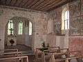 Interior of the chapel
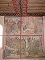 Paintings on the south wall of the chapel
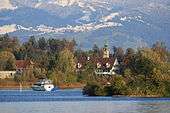
_-_Busskirch_St_Martin_IMG_2217_ShiftN.jpg) St. Martin Busskirch on Obersee (upper Lake Zürich)
St. Martin Busskirch on Obersee (upper Lake Zürich)_-_Busskirch_St_Martin_IMG_2206_ShiftN.jpg) inside the medieval Parish church
inside the medieval Parish church_-_Busskirch_St_Martin_IMG_4774_ShiftN.jpg) Höllenrachen (Last Judgement) painting inside St. Martin
Höllenrachen (Last Judgement) painting inside St. Martin_-_Lenggis_Spitzewies_IMG_4965.JPG) Meienberg hill
Meienberg hill Rathaus (Town hall) of Rapperswil
 Schloss Rapperswil and Stadtpfarrkirche (St. John's church)
 Polish Museum at the Schloss
 Seedamm bridge across the lake
 reconstruction of the original wooden bridge from c. 1525 BC between Rapperswil and Hurden
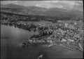 Aerial view (1954)
 Aerial view (1962)
Notable people
and
See also
- Settlements comprised by the municipality of Rapperswil-Jona
- Bollingen
- Busskirch
- Jona
- Kempraten
- Rapperswil
- Points of interest
- Circus Knie
- Heilig Hüsli
- Hochschule für Technik Rapperswil
- Holzbrücke Rapperswil-Hurden
- Kapuzinerkloster Rapperswil
- Knies Kinderzoo
- Paddle steamer Stadt Rapperswil
- Polish Museum, Rapperswil
- Rapperswil Castle
- Rathaus Rapperswil
- Seedamm
- Stadtmuseum Rapperswil
- Stadtpfarrkirche Rapperswil
- Wurmsbach Abbey
References
- "Arealstatistik Standard - Gemeinden nach 4 Hauptbereichen". Federal Statistical Office. Retrieved 13 January 2019.
- "Ständige Wohnbevölkerung nach Staatsangehörigkeitskategorie Geschlecht und Gemeinde; Provisorische Jahresergebnisse; 2018". Federal Statistical Office. 9 April 2019. Retrieved 11 April 2019.
- Amtliches Gemeindeverzeichnis der Schweiz published by the Swiss Federal Statistical Office (in German) accessed 23 September 2009
- Swiss Federal Statistical Office - STAT-TAB, online database – Ständige und nichtständige Wohnbevölkerung nach institutionellen Gliederungen, Geburtsort und Staatsangehörigkeit (in German) accessed 23 September 2019
- Swiss Federal Statistical Office accessed 7 January 2010
- map.geo.admin.ch (Map). Swiss Confederation. Retrieved 16 December 2011.
- "S-Bahn trains, buses and boats" (PDF). ZVV. Archived from the original (PDF) on 29 September 2011. Retrieved 16 December 2011.
- "Marktgebiet" [Market area] (in German). VZO. Archived from the original on 4 October 2013. Retrieved 2 October 2013.
- "FOKUS: Mobility Pricing soll Pendlerverkehr entlasten" (in German). 10vor10. 30 June 2016. Retrieved 30 June 2016.
- "Aalborg Twin Towns". Europeprize.net. Archived from the original on 7 September 2013. Retrieved 19 August 2013.
- "A-Objekte KGS-Inventar". Schweizerische Eidgenossenschaft, Amt für Bevölkerungsschutz. 2009. Archived from the original on 28 June 2010. Retrieved 7 December 2014.
- "Sites Switzerland: Freienbach–Hurden Rosshorn (CH-SZ-01)". palafittes.org. Archived from the original on 7 October 2014. Retrieved 8 December 2014.
- "Sites Switzerland: Freienbach–Hurden Rosshorn (CH-SZ-02)". palafittes.org. Archived from the original on 7 October 2014. Retrieved 8 December 2014.
- "Sites Switzerland: Rapperswil-Jona/Hombrechtikon–Feldbach (CH-SG-01)". palafittes.org. Archived from the original on 7 October 2014. Retrieved 8 December 2014.
- "Sites Switzerland: Rapperswil-Jona–Technikum (CH-SG-02)". palafittes.org. Archived from the original on 7 October 2014. Retrieved 8 December 2014.
External links
| Wikivoyage has a travel guide for Rapperswil. |
| Wikimedia Commons has media related to Rapperswil-Jona. |
- Rapperswil-Jona (official site) (in German)
- Capuchin monastery (in German)
- University of Applied Sciences Rapperswil, HSR (university)
- A brief history of Rapperswil
- Bollingen in German, French and Italian in the online Historical Dictionary of Switzerland.
- Busskirch in German, French and Italian in the online Historical Dictionary of Switzerland.
- Jona in German, French and Italian in the online Historical Dictionary of Switzerland.
- Kempraten in German, French and Italian in the online Historical Dictionary of Switzerland.
Municipalities in See-Gaster district, Switzerland | ||
|---|---|---|
Lake Zurich (Zürichsee) | ||
|---|---|---|
| Settlements |
|   |
| Islands | ||
| Rivers | ||
| Valleys | ||
| Mountains | ||
| Landmarks | ||
| Transportation |
| |
| People | ||
| Authority control |
|
|---|