Westphalia, Indiana
Westphalia is an unincorporated community and census-designated place (CDP) in Vigo Township, Knox County, Indiana. As of the 2010 census it had a population of 202.[3]
Westphalia, Indiana | |
|---|---|
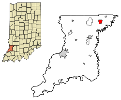 Location in Knox County, Indiana | |
 Westphalia Location in Knox County, Indiana  Westphalia Westphalia (the United States) | |
| Coordinates: 38°51′46″N 87°13′32″W | |
| Country | United States |
| State | Indiana |
| County | Knox |
| Township | Vigo |
| Named for | Westphalia |
| Elevation | 466 ft (142 m) |
| Population (2010) | |
| • Total | 202 |
| • Density | 98/sq mi (37.8/km2) |
| Time zone | UTC-5 (EST) |
| • Summer (DST) | UTC-4 (EDT) |
| ZIP code | 47596 |
| FIPS code | 18-83204[2] |
| GNIS feature ID | 445855 |
History
Westphalia was laid out in 1881, and it was originally built up chiefly by Germans.[4] It was named after the region of Westphalia in Germany.[5] The Westphalia post office was established in 1881.[6] Many businesses have existed over the history of Westphalia including a variety store, antique store, hotel, blacksmith, elevator, photo studio, mine supply and the Westphalia elementary school.
Geography
Westphalia is located in northeastern Knox County at 38°51′46″N 87°13′32″W. Indiana State Road 67 passes through the center of the community, leading northeast 3 miles (5 km) to Sandborn and southwest 4 miles (6 km) to Edwardsport and 23 miles (37 km) to Vincennes, the Knox county seat. Indiana State Road 58 joins SR 67 northeast out of Westphalia but leads west 5 miles (8 km) to Freelandville.
According to the U.S. Census Bureau, the Westphalia CDP has an area of 2.06 square miles (5.34 km2), all of it land.[3]
Places of interest
Westphalia has a locally owned restaurant, Country Charms Café, a playground, a church, Salem United Church of Christ, low income senior apartments and a post office. Westphalia is a rural community.
References
- "US Board on Geographic Names". United States Geological Survey. 2007-10-25. Retrieved 2008-01-31.
- "U.S. Census website". United States Census Bureau. Retrieved 2008-01-31.
- "Geographic Identifiers: 2010 Demographic Profile Data (G001): Westphalia CDP, Indiana". American Factfinder. U.S. Census Bureau. Retrieved February 27, 2019.
- History of Knox and Daviess County, Indiana: From the Earliest Time to the Present. Goodspeed. 1886. pp. 272.
- Dept. of English and Journalism (1970–72). Indiana names, v.1-3. Indiana State University. p. 15.
- "Knox County". Jim Forte Postal History. Retrieved 25 November 2014.
- "Census of Population and Housing". Census.gov. Retrieved June 4, 2016.
Municipalities and communities of Knox County, Indiana, United States | ||
|---|---|---|
| Cities | Map of Indiana highlighting Knox County | |
| Towns | ||
| Townships | ||
| CDPs | ||
| Other unincorporated communities | ||