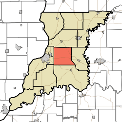
Palmyra Township, Knox County, Indiana
Palmyra Township is one of ten townships in Knox County, Indiana. As of the 2010 census, its population was 1,466 and it contained 612 housing units.[3]
Palmyra Township | |
|---|---|
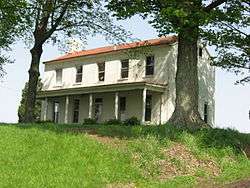 Rose Hill Farmstead, a historic site in the township | |
 | |
| Coordinates: 38°40′49″N 87°24′34″W | |
| Country | United States |
| State | Indiana |
| County | Knox |
| Government | |
| • Type | Indiana township |
| Area | |
| • Total | 37.48 sq mi (97.1 km2) |
| • Land | 37.47 sq mi (97.0 km2) |
| • Water | 0.01 sq mi (0.03 km2) |
| Elevation | 505 ft (154 m) |
| Population (2010) | |
| • Total | 1,466 |
| • Density | 39.1/sq mi (15.1/km2) |
| FIPS code | 18-57744[2] |
| GNIS feature ID | 453704 |
History
Shadowwood was added to the National Register of Historic Places in 2001.[4] Rose Hill Farmstead was formerly listed.[5]
Geography
According to the 2010 census, the township has a total area of 37.48 square miles (97.1 km2), of which 37.47 square miles (97.0 km2) (or 99.97%) is land and 0.01 square miles (0.026 km2) (or 0.03%) is water.[3]
References
- "US Board on Geographic Names". United States Geological Survey. 2007-10-25. Retrieved 2008-01-31.
- "U.S. Census website". United States Census Bureau. Retrieved 2008-01-31.
- "Population, Housing Units, Area, and Density: 2010 - County -- County Subdivision and Place -- 2010 Census Summary File 1". United States Census. Archived from the original on 2020-02-12. Retrieved 2013-05-10.
- "National Register Information System". National Register of Historic Places. National Park Service. July 9, 2010.
- "National Register of Historic Places Listings". Weekly List of Actions Taken on Properties: 6/11/12 through 6/15/12. National Park Service. 2012-06-22.
External links
Municipalities and communities of Knox County, Indiana, United States | ||
|---|---|---|
| Cities | Map of Indiana highlighting Knox County | |
| Towns | ||
| Townships | ||
| CDPs | ||
| Other unincorporated communities | ||
This article is issued from Wikipedia. The text is licensed under Creative Commons - Attribution - Sharealike. Additional terms may apply for the media files.