Westlands, Nairobi
Westlands is an affluent, mixed-use commercial and residential neighborhood in Nairobi, the capital city of Kenya. Westlands is also one of the eight administrative divisions of Nairobi County, which is coterminous with Nairobi City. The other divisions are Central, Dagoretti Embakasi, Kasarani, Kibera, Makadara and Pumwani.[1]
Westlands | |
|---|---|
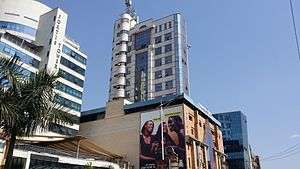 Woodvale Grove, Westlands, Nairobi | |
| Nickname(s): Westie | |
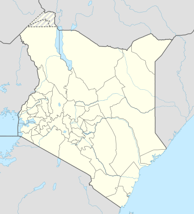 Westlands Location of Westlands in Kenya | |
| Coordinates: 01°16′12″S 36°48′36″E | |
| Country | |
| County | Nairobi County |
| City | Nairobi |
| City Division | Westlands |
| Area | |
| • Land | 37.6 sq mi (97.5 km2) |
| Elevation | 5,600 ft (1,700 m) |
| Population (2019) | |
| • Total | 308,854 |
Location
Westlands is located approximately 3.2 kilometres (2 mi), by road, northwest of the central business district of Nairobi.[2] The geographical coordinates of the neighborhood are:01°16'01.0"S, 36°48'42.0"E (Latitude:-1.266944; Longitude:36.811667).[3]
Overview
Westlands was a residential district during the colonial period which ended in 1963. Then, it housed mainly Kenyan Asians of Indian descent.[4]
During the 1990s and early 2000s, as land and office space became scarce and exorbitantly priced in the central business district, more businesses have relocated to Westlands and Upper Hill, where land and office space are more readily available and less expensive. Westlands was initially considered part of the Parklands area and straddled what is now Waiyaki Way, originally the Kenya-Uganda Railway. The area has been nicknamed Westie by the youth of Nairobi. It is nowadays typically inhabited by a significant number of the city's expatriate population. Muthaiga, a neighborhood to the northeast of Westlands proper, but within the Westlands Division of the county, is rated the most affluent and most expensive neighborhood in the country.[5]
Points of interest
In Westlands or near the boundaries of the neighbourhood, there are several points of interest, including the following:[3]
- UNHCR branch office in Kenya
- The Sarit Centre Shopping Mall
- The Ukay Shopping Mall
- The Westgate Shopping Mall
- The M. P. Shah Hospital, a private hospital
- Unga House – An office high-rise building
- Mpaka Road – Many businesses have offices on this street
- USAID Towers – The headquarters of USAID in Kenya
- The High Commission of Botswana to Kenya
- The Embassy of Norway to Kenya
- The Embassy of Sweden to Kenya
- Westlands Office Park
- Westlands Primary School
- Datoo's Glassware Mart Ltd
- An office of PricewaterhouseCoopers
- Sankara Hotel
- Dusit D2
- Phillips Pharmaceuticals Head office
- Delta Towers
- Safaricom Head Office
- Art Cafe Head office
- Java Head office
- Villa Rosa Kempinski Nairobi
- Movenpick Hotel
- A branch of Woolworth Stores
- The Nairobi Institute of Technology

Kuza Biashara, a company that trains small business owners and youth is also found in Westlands
Westlands Division
Apart from being a commercial centre, Westlands is also one of the eight administrative divisions in Nairobi. The division consists of the following six subdivisions:
Westlands is also an electoral constituency, the Westlands Constituency. It has the same borders with Westlands Division.[6]
Deep Sea Settlement
Within the Westlands Division lies the Deep Sea Settlement. This is a shanty town of approximately 7,000 inhabitants. In 2005 a private firm, with police support, began bulldozing homes, an act the Kenyan high court deemed illegal. The High Court viewed the 'law' that allowed the private firm land rights' as unfair, because the area harboured squatters for more than 12 years. Combined with this land-rights issue, poverty is rife and is exacerbated by the area's poor sanitation.[7]
Education
The Lycée Denis Diderot opened in Westlands as the École française à Nairobi in 1962. It moved to Kilimani in 1972.[8] There are many other educational institutions in Westlands Division, as detailed in this reference.[5]
References
- Venic Nyanchama (2019). "List of Nairobi County Wards". Nairobi: Tuko Kenya. Retrieved 19 May 2020.
- Google (19 May 2020). "Road Distance Between General Post Office Nairobi and Westlands, Nairobi" (Map). Google Maps. Google. Retrieved 19 May 2020.
- Google (19 May 2020). "Location of Westlands, Nairobi" (Map). Google Maps. Google. Retrieved 19 May 2020.
- Karl Vick (15 March 2000). "A New View of Kenya's 'Asians'". The Washington Post. Washington, DC. Retrieved 19 May 2020.
- Nancy A. Ruthling (5 October 2019). "Muthaiga is Nairobi's Most-Affluent Neighborhood, Offering Privacy and Lush Landscapes". Mansionglobal.com. Retrieved 19 May 2020.
- Gabriel Kamau Kung'u (2011). "Factors Influencing SMEs Access To Finance: A Case Study of Westland Division, Kenya". Munich, Germany: Munich Personal RePEc Archive. Retrieved 20 May 2020.
- Halima Gikandi (10 July 2019). "Their shack settlement was told to move. Their demand: Move us together". Christian Science Monitor. Retrieved 20 May 2020.
- "Accueil." Lycée Denis Diderot. Retrieved on 18 January 2015.