Aerial archaeology
Aerial archaeology is the study of archaeological remains by examining them from altitude.
Details
The advantages of gaining a good aerial view of the ground had been long appreciated by archaeologists as a high viewpoint permits a better appreciation of fine details and their relationships within the wider site context. Early investigators attempted to gain birdseye views of sites using hot air balloons, scaffolds or cameras attached to kites. Following the invention of the aeroplane and the military importance placed on aerial photography during the First and Second World Wars, archaeologists were able to more effectively use the technique to discover and record archaeological sites.
Photographs may be taken either vertically, that is from directly overhead, or obliquely, meaning that they are taken at an angle. In order to provide a three-dimensional effect, an overlapping pair of vertical photographs, taken from slightly offset positions, can be viewed stereoscopically.
The advantages of aerial photographs to archaeologists are manifold.
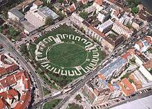
Large sites could for the first time be viewed accurately, in their entirety and within their landscape. This aided the production of drawn plans and also inspired archaeologists to look beyond the discrete monument and to appreciate a site's role within its setting. Photos are taken vertically for the purposes of planning and spatial analysis and obliquely to emphasize certain features or give perspective. Through the process of photogrammetry, vertical photos can be converted into scaled plans.
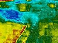
Archaeological features may also be more visible from the air than on the ground. In temperate Europe, aerial reconnaissance is one of the most important ways in which new archaeological sites are discovered. Tiny differences in ground conditions caused by buried features can be emphasised by a number of factors and then viewed from the air:
- Slight differences in ground levels will cast shadows when the sun is low and these can be seen best from an aeroplane. These are referred to as shadow marks.
- Buried ditches will hold more water and buried walls will hold less water than undisturbed ground, this phenomenon, amongst others, causes crops to grow better or worse, taller or shorter, over each kind of ground and therefore define buried features which are apparent as tonal or colour differences. Such effects are called cropmarks.
- Frost can also appear in winter on ploughed fields where water has naturally accumulated along the lines of buried features. These are known as frostmarks.
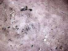
- Slight differences in soil colour between natural deposits and archaeological ones can also often show in ploughed fields as soilmarks
- Differences in levels and buried features will also affect the way surface water behaves across a site and can produce a striking effect after heavy rain.
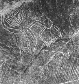
In cases like the Nazca lines, the features are meaningless from the ground but easily visible from the air.
Pioneers of aerial archaeology include Roger Agache in Northern France, Antoine Poidebard in Syria, L W B Rees in Jordan O. G. S. Crawford in England and Sir Henry Wellcome in the Sudan, Giacomo Boni in Italy.
Following in the footsteps of Henry Wellcome, kite aerial photography is now being used on archaeological sites outside the visible spectrum, from the near ultra-violet through to the near and thermal infra-red.
Aerial archaeology is used in the processes of research and investigation in aviation archaeology.
See also
- Archaeological field survey
- Cropmark
- Markus Casey
- Shadow marks
References
- Bibliography
- Bourgeois, J. and Meganck, M. (eds.) (2005). Aerial Photography and Archaeology 2003. A Century of Information. Archaeological Reports Ghent University 4. Ghent: Academia Press. ISBN 90-382-0782-4
- Brophy, K. and Cowley, D. (eds.) (2005). From the air: understanding aerial archaeology. London: The History Press. ISBN 0-7524-3130-7
- Riley, D. N. (1987). Air photography and archaeology. Univ of Pennsylvania. ISBN 0-8122-8087-3
- Wilson, D. R . (2000). Air photo interpretation for archaeologists, London: The History Press. (2nd edn.). ISBN 0-7524-1498-4
External links
| Wikimedia Commons has media related to Aerial archaeology. |
- Emporia State University: Aerial Archaeology
- Aerial and Remote Sensing Archaeology Link and Reference Site
- Aerial Archaeology. AerialArchaeology.com focuses heavily on near-earth imaging technologies such as kite aerial photography, remote-control powered parachutes, balloons, and model airplanes and helicopters. *** Off-line April 20, 2010 ***
- ACE Foundation
- Kite Aerial Photographers - Archaeology
- Sir Henry Wellcome
- Aerial Archaeology in Northern France
| History | |||||||||
|---|---|---|---|---|---|---|---|---|---|
| Methodology |
| ||||||||
| Sub-disciplines |
| ||||||||
| |||||||||