West Lakes Shore, South Australia
West Lakes Shore is a suburb in the Australian state of South Australia located in the Adelaide metropolitan area about 12 kilometres (7.5 mi) north-west of the Adelaide city centre and about 5 kilometres (3.1 mi) west of the municipal seat of Woodville.[1][4]
| West Lakes Shore Adelaide, South Australia | |||||||||||||||
|---|---|---|---|---|---|---|---|---|---|---|---|---|---|---|---|
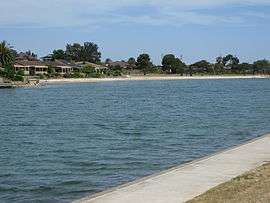 The man-made lake | |||||||||||||||
 West Lakes Shore | |||||||||||||||
| Coordinates | 34°52′05″S 138°29′00″E[1] | ||||||||||||||
| Population | 3,112 (2016 census)[2] | ||||||||||||||
| Established | 30 September 1976[3] | ||||||||||||||
| Postcode(s) | 5020[4] | ||||||||||||||
| Time zone | ACST (UTC+9:30) | ||||||||||||||
| • Summer (DST) | ACST (UTC+10:30) | ||||||||||||||
| Location | |||||||||||||||
| LGA(s) | City of Charles Sturt[1] | ||||||||||||||
| Region | Western Adelaide[1] | ||||||||||||||
| County | Adelaide[1] | ||||||||||||||
| State electorate(s) | Lee[5] | ||||||||||||||
| Federal Division(s) | Hindmarsh[6] | ||||||||||||||
| |||||||||||||||
| |||||||||||||||
| Footnotes | Locations[1][4] Adjoining suburbs[1] | ||||||||||||||
West Lakes Shore is located in the federal division of Hindmarsh, the state electoral district of Lee and the local government area of the City of Charles Sturt.[6][5][1]
History
West Lakes Shore and its larger sister suburb West Lakes were created from the low-lying wasteland and coastal sand dunes formerly known as "The Greater Port Adelaide Development Area". In 1969 an Indenture was signed by the South Australian Government and the Delfin Group for the joint development of this area which measures 4.83 km long and 1.6 km wide.
Since that time West Lakes and West Lakes Shore have become a thriving community of 8,800 people enjoying sporting, shopping, educational and recreational facilities in a fully planned development renowned nationally for its excellence in planning and design.[8]
West Lakes Shore Post Office opened on 21 May 1997 replacing the nearby Semaphore Park office.[9]
People
The total population of West Lakes Shore at the 2006 Census was 2965.
In the 2006 census the population comprised 48.5% males and 51.5% females.
Children aged between 0 –14 years accounted for 12.2% of the total population, while 36.0% were persons aged 55 years and over.
The median age was 47 years compared to the national median age of all Australians of 37 years.
The vast majority (74.8%) of the residents were born in Australia, with 6.4% born in England and 2.3% in Italy.
Landmarks
The major landmarks in the suburb include:
- West Lakes Shore R-7 School[10]
- SA Rowing and Aquatic Centre
- The lake - West Lakes
- West Lakes Shore Beach
- West Lakes Uniting Church[11]
- Bartley Terrace Shopping Centre
- The parks, including Neighbourhood Reserve, Jubilee Reserve (known locally as Hawkesbury Reserve), and Heysen Reserve
- Bartley Tavern
- West Lakes Shore Oval. The clubs that use this oval are
- West Lakes Sports Club Inc[12]
- SMOSH West Lakes Football Club Inc
- Henley & Grange Baseball Club Inc
- Port Adelaide Softball Club Inc
Schools and recreation
West Lakes Shore R-7 School is located on Edwin Street and caters for children from Reception to Year 7.
West Lakes Sports Club Inc, located on the East side of Bartley Tce was established in 2002 and is home to the Henley & Grange Baseball Club, SMOSH West Lakes Senior and Junior Football Club, Port Adelaide Softball Club, Current Affairs Group and the West Lakes Social Club, and is also available to the public for functions and dining.[12]
Club West Lakes (previously known as The Lakes Sports and Community Club) was built in 1986 and is home to the West Lakes Bowling Club, Tennis Club, and Croquet Club. Combined it has over 800 members.
RowingSA and the West Lakes Aquatic Centre are based on the lakefront, alongside Military Road. Each year during March, the Centre hosts the annual Head of the River Carnival.
With access to the waters of West Lakes and with generally flat terrain, various sporting organisations conduct triathlons around the streets and in the lake. Usually these triathlons are held in the autumn months.
References
- "Search results for 'West Lakes Shore, SUB' with the following datasets selected - 'Suburbs and localities', 'Counties', 'Local Government Areas', 'SA Government Regions' and 'Gazetteer'". Location SA Map Viewer. South Australian Government. Retrieved 17 July 2019.
- Australian Bureau of Statistics (27 June 2017). "West Lakes Shore (State Suburb)". 2016 Census QuickStats. Retrieved 17 July 2019.

- Casey, T.M. (30 September 1976). "GEOGRAPHICAL NAMES ACT" (PDF). The South Australian Government Gazette. Government of South Australia. p. 1035. Retrieved 15 July 2019.
the Geographical Names Board has recommended that the names “West Lakes Shore”, “West Lakes”, “Semaphore Park”, “Tennyson”, “Seaton”, “Grange” and “Royal Park” be assigned to the areas defined hereunder in the first, second, third, fourth, fifth, sixth and seventh schedules respectively
- "Postcode for West Lakes Shore, South Australia". Postcodes Australia. Retrieved 17 July 2019.
- "Electoral district profiles - Lee (2018-2022 boundaries)". Electoral Commission SA. Retrieved 15 July 2019.
- "Profile of the electoral division of Hindmarsh (SA)". Australian Electoral Commission. Retrieved 15 July 2019.
- "Monthly climate statistics: Summary statistics ADELAIDE AIRPORT (nearest weather station)". Commonwealth of Australia , Bureau of Meteorology. Retrieved 15 July 2019.
- Marsden, S. (2015): A year-round holiday: the histories of West Lakes. Wakefield Press. ISBN 978 1 74305 352 2
- Premier Postal History. "Post Office List - search result for "West Lakes Shore"". Premier Postal Auctions. Retrieved 17 July 2019.
- West Lakes Shore R-7 School Accessed 5 June 2014.
- West Lakes Uniting Church Accessed 5 June 2014.
- "West Lakes Sports Club". Retrieved 4 June 2014.
| Wikimedia Commons has media related to West Lakes Shore, South Australia. |