Wendover, Utah
Wendover is a city on the western edge of Tooele County, Utah, United States. The population was 1,400 at the 2010 census.[5]
Wendover, Utah | |
|---|---|
 | |
 Location in Tooele County and the state of Utah | |
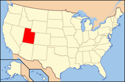 Location of Utah in the United States | |
| Coordinates: 40°44′8″N 114°1′59″W | |
| Country | United States |
| State | Utah |
| County | Tooele |
| Founded | 1908 |
| Named for | "Wending over" the desert |
| Government | |
| • Mayor | Mike Crawford |
| Area | |
| • Total | 8.93 sq mi (23.12 km2) |
| • Land | 8.93 sq mi (23.12 km2) |
| • Water | 0.00 sq mi (0.00 km2) |
| Elevation | 4,291 ft (1,308 m) |
| Population (2010) | |
| • Total | 1,400 |
| • Estimate (2018)[2] | 1,469 |
| • Density | 164.56/sq mi (63.53/km2) |
| Time zone | UTC-7 (Mountain (MST)) |
| • Summer (DST) | UTC-6 (MDT) |
| ZIP code | 84083 |
| Area code(s) | 435 |
| FIPS code | 49-82730[3] |
| GNIS feature ID | 1434042[4] |
| Website | Official website |
Description
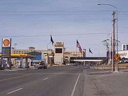
Wendover is on the western border of Utah, and is contiguous with West Wendover, Nevada. Interstate 80 runs just north of both cities, while Interstate 80 Business (Wendover Boulevard) runs through the two cities. The Wendover Cut-off was the former path of the Victory Highway as well as U.S. Route 40 to Wendover. Today it serves as a frontage road between Wendover and Knolls just to the south of the Interstate.
History
The town was established in 1908 as a station stop on the Western Pacific Railroad, then under construction.[6]
The transcontinental telephone line was completed as workers raised the final pole at Wendover, Utah on June 27, 1914, after construction of 3,400 miles (5,500 km) of telephone line. However, the line was not utilized until January 25, 1915, when the first transcontinental telephone call was made to coincide with the opening of the Panama Pacific Exposition.[7]
From 1917 to 1939, a Western Pacific subsidiary known as the Deep Creek Railroad also operated into Wendover. The Western Pacific became part of the larger Union Pacific Railroad in 1983.
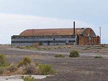
During World War II, the nearby Wendover Army Air Field (later known as the Wendover Air Force Base) was a training base for bomber pilots, including the crew of the Enola Gay. The Enola Gay was stationed here until June 1945.[8]
In 2008, the Utah Department of Transportation completed an interchange at Aria Boulevard on Interstate 80. Investment is also underway to restore the Wendover Airport (located at the former Wendover Air Force Base)[9] which is currently managed by Tooele County.
Tooele County School District has completed Anna Smith Elementary School which serves the Wendover area.[10] Wendover and Tooele County recently built a joint complex for municipal and county functions.
Movements to unite Wendover with West Wendover, which is located across the border in Nevada and allows gambling operations, have taken place but require the approval of the U.S. Congress and the Nevada and Utah legislatures.[11] The U.S. House of Representatives passed a resolution permitting Wendover to leave Utah and join Nevada in 2002, but the bill was stalled in the U.S. Senate and did not become law.[12][13]
Demographics
| Historical population | |||
|---|---|---|---|
| Census | Pop. | %± | |
| 1920 | 180 | — | |
| 1930 | 205 | 13.9% | |
| 1940 | 272 | 32.7% | |
| 1950 | 814 | 199.3% | |
| 1960 | 609 | −25.2% | |
| 1970 | 781 | 28.2% | |
| 1980 | 1,099 | 40.7% | |
| 1990 | 1,127 | 2.5% | |
| 2000 | 1,537 | 36.4% | |
| 2010 | 1,400 | −8.9% | |
| Est. 2018 | 1,469 | [2] | 4.9% |
| U.S. Decennial Census[14] | |||
As of the census[3] of 2000, there were 1,537 people, 432 households, and 327 families residing in the city. The population density was 238.9 people per square mile (92.3/km²). There were 510 housing units at an average density of 79.3 per square mile (30.6/km²). The racial makeup of the city was 43.98% White, 1.17% African American, 1.76% Native American, 0.85% Asian, 0.13% Pacific Islander, 43.59% from other races, and 8.52% from two or more races. Hispanic or Latino of any race were 68.64% of the population.
There were 432 households out of which 54.9% had children under the age of 18 living with them, 56.9% were married couples living together, 11.6% had a female householder with no husband present, and 24.1% were non-families. 16.7% of all households were made up of individuals and 3.5% had someone living alone who was 65 years of age or older. The average household size was 3.56 and the average family size was 4.10.
In the city, the population was spread out with 39.9% under the age of 18, 13.0% from 18 to 24, 30.0% from 25 to 44, 13.2% from 45 to 64, and 3.9% who were 65 years of age or older. The median age was 24 years. For every 100 females, there were 106.3 males. For every 100 females age 18 and over, there were 106.7 males.
The median income for a household in the city was $31,196, and the median income for a family was $29,722. Males had a median income of $18,417 versus $20,682 for females. The per capita income for the city was $10,794. About 24.7% of families and 26.1% of the population were below the poverty line, including 29.1% of those under age 18 and 16.1% of those age 65 or over.
Government
Wendover uses a city council with five council members that meet on the first and third Thursday of every month. As of March 2020, the current mayor of Wendover is Mike Crawford.[15]
Geography
According to the United States Census Bureau, the city has a total area of 6.4 square miles (16.7 km²), all of it land.
The hillside letter W can be seen in the north. (40.7454°N 114.0297°W)
Climate
According to the Köppen Climate Classification system, Wendover has an arid climate, abbreviated "BWk" on climate maps.[16]
| Climate data for West Wendover Air Force Base | |||||||||||||
|---|---|---|---|---|---|---|---|---|---|---|---|---|---|
| Month | Jan | Feb | Mar | Apr | May | Jun | Jul | Aug | Sep | Oct | Nov | Dec | Year |
| Record high °F (°C) | 64 (18) |
80 (27) |
81 (27) |
92 (33) |
103 (39) |
105 (41) |
112 (44) |
110 (43) |
103 (39) |
90 (32) |
78 (26) |
65 (18) |
112 (44) |
| Average high °F (°C) | 35.8 (2.1) |
42.9 (6.1) |
53.1 (11.7) |
62.5 (16.9) |
72.7 (22.6) |
82.9 (28.3) |
92.5 (33.6) |
89.9 (32.2) |
78.9 (26.1) |
63.7 (17.6) |
47.6 (8.7) |
37.0 (2.8) |
63.3 (17.4) |
| Average low °F (°C) | 18.7 (−7.4) |
24.4 (−4.2) |
32.0 (0.0) |
40.1 (4.5) |
49.4 (9.7) |
58.4 (14.7) |
67.0 (19.4) |
64.4 (18.0) |
53.3 (11.8) |
41.3 (5.2) |
28.9 (−1.7) |
20.5 (−6.4) |
41.5 (5.3) |
| Record low °F (°C) | −16 (−27) |
−12 (−24) |
8 (−13) |
19 (−7) |
26 (−3) |
31 (−1) |
43 (6) |
36 (2) |
28 (−2) |
18 (−8) |
5 (−15) |
−18 (−28) |
−18 (−28) |
| Average precipitation inches (mm) | 0.28 (7.1) |
0.28 (7.1) |
0.37 (9.4) |
0.48 (12) |
0.72 (18) |
0.51 (13) |
0.25 (6.4) |
0.34 (8.6) |
0.34 (8.6) |
0.47 (12) |
0.29 (7.4) |
0.25 (6.4) |
4.58 (116) |
| Average snowfall inches (cm) | 1.6 (4.1) |
1.4 (3.6) |
0.5 (1.3) |
0.2 (0.51) |
0.0 (0.0) |
0.0 (0.0) |
0.0 (0.0) |
0.0 (0.0) |
0.0 (0.0) |
0.1 (0.25) |
0.4 (1.0) |
1.3 (3.3) |
5.5 (14.06) |
| Source: [17] | |||||||||||||
See also
- List of cities in Utah
References
- "2018 U.S. Gazetteer Files". United States Census Bureau. Retrieved Feb 16, 2020.
- "Population and Housing Unit Estimates". Retrieved June 4, 2019.
- "U.S. Census website". United States Census Bureau. Retrieved 2011-05-14.
- "US Board on Geographic Names". United States Geological Survey. 2007-10-25. Retrieved 2008-01-31.
- "Wendover, UT Population - Census 2010 and 2000 Interactive Map, Demographics, Statistics, Quick Facts - CensusViewer". censusviewer.com. Retrieved 2019-02-04.
- Hall, Shawn (June 2, 2002). Connecting the West: Historic Railroad Stops and Stage Stations of Elko County, Nevada. University of Nevada Press. p. 196. ISBN 978-0-87417-499-1. Retrieved December 14, 2010.
- "ATT, First Transcontinental Line". Archived from the original on 2017-09-08. Retrieved 2019-02-05.
- "11 Most Endangered Historic Places: The Manhattan Project's Enola Gay Hangar". PreservationNation.org. National Trust for Historic Preservation. n.d. Archived from the original on 17 December 2011. Retrieved 6 May 2019.
- Nielson-Stowell, Amelia (March 10, 2006). "U.S. grant to help Wendover Airfield". Deseret Morning News.
- "Anna Smith Elementary School". TooeleSchools.org. Tooele County School District. n.d. Retrieved 6 May 2019.
- "Article IV". U.S. Constitution. Cornell University Legal Information Institute. Retrieved March 17, 2011.
- Eddington, Mark (November 23, 2002). "Wendovers' Leaders Will Consider Next Move". Salt Lake Tribune.
- "Actions - H.R.2054 - 107th Congress (2001-2002): To give the consent of Congress to an agreement or compact between Utah and Nevada regarding a change in the boundaries of those States, and for other purposes". Congress.gov. Library of Congress. Retrieved 2020-03-29.
- "Census of Population and Housing". Census.gov. Retrieved June 4, 2015.
- "City Council". City of Wendover. Retrieved March 19, 2020.
- Climate Summary for Wendover, Utah
- "WENDOVER USAF AUX FLD, UTAH (429382)". Western Regional Climate Center. Retrieved June 5, 2016.
External links
| Wikimedia Commons has media related to Wendover, Utah. |
| Wikivoyage has a travel guide for Wendover. |
- Official website
- Historic Wendover Airfield -- Non-profit foundation
- A Visit to Wendover Field Archived 13 May 2013 at the Wayback Machine
- The short film A CONTINENT IS BRIDGED (Reel 1 of 4) (1940) is available for free download at the Internet Archive
Places adjacent to Wendover, Utah | |
|---|---|
Municipalities and communities of Tooele County, Utah, United States | ||
|---|---|---|
| Cities | 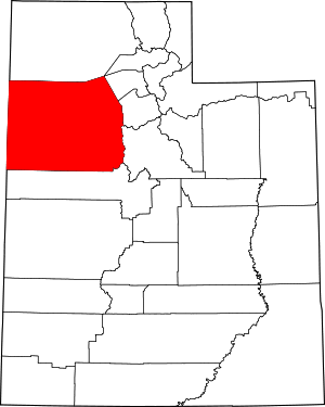 Map of Utah highlighting Tooele County | |
| Towns | ||
| CDPs | ||
| Unincorporated communities | ||
| Ghost towns | ||
| Indian reservations | ||
| Footnotes | ‡This populated place also has portions in an adjacent county or counties | |
| Authority control |
|
|---|