Wells-next-the-Sea
Wells-next-the-Sea is a small town and port on the North Norfolk coast of England.
| Wells-next-the-Sea | |
|---|---|
 The quayside | |
 Wells-next-the-Sea Location within Norfolk | |
| Area | 16.31 km2 (6.30 sq mi) |
| Population | 2,165 (2011 Census) |
| • Density | 133/km2 (340/sq mi) |
| OS grid reference | TF 914 430 |
| District | |
| Shire county | |
| Region | |
| Country | England |
| Sovereign state | United Kingdom |
| Post town | WELLS-NEXT-THE-SEA |
| Postcode district | NR23 |
| Dialling code | 01328 |
| Police | Norfolk |
| Fire | Norfolk |
| Ambulance | East of England |
| UK Parliament | |
The civil parish has an area of 16.31 km2 (6.30 sq mi) and in 2001 had a population of 2,451,[1] reducing to 2,165 at the 2011 census.[2]
Wells is 15 miles (24 km) to the east of the resort of Hunstanton, 20 miles (32 km) to the west of Cromer, and 10 miles (16 km) north of Fakenham. The city of Norwich lies 32 miles (51 km) to the south-east. Nearby villages include Blakeney, Burnham Market, Burnham Thorpe, Holkham and Walsingham.[3]
Origin of name
The name is Guella in the Domesday Book (half gallicised, half Latinised from Anglian Wella, a spring). This derives from spring wells of which Wells used to have many, rising through the chalk of the area. The town became Wells-next-the-Sea from juxta mare in the fourteenth century to distinguish it from other places of the same name. It appears as Wells Next The Sea (no hyphens) on the Ordnance Survey maps of 1838 and 1921. When the Wells and Fakenham Railway was opened on 1 December 1857, the terminus was given the name of Wells-on-Sea. In 1956 the Wells Urban District Council voted to (re-)adopt the name Wells-next-the-Sea, and this has been the official name since then.[4]
History
The North Sea is now a mile from the town; the main channel which once wandered through marshes, grazed by sheep for hundreds of years, was confined by earthworks to the west in 1859 when Holkham Estate reclaimed some 800 hectares of saltmarsh north-west of Wells with the building of a mile-long bank.[5] This reclamation was claimed to have reduced the tidal scour though the West Fleet which provided much of the water entered the channel to its north.
Because the town has no river running through it, Wells relies on the tides to scour the harbour. The problem of siltation had preoccupied the merchants of the town for hundreds of years and occupied the attentions of various engineers, leading eventually to disputes which came to court in the eighteenth century. Sir John Coode, who had been knighted for his work on the completion of Portland harbour was recruited to solve its siltation problems in the 1880s. No attempted solution proved permanent. The growth of faster marine traffic whose wake washes at the banks of the marshes has widened the channel and reduced tidal flow further.
The town has been a seaport since before the fourteenth century when it supplied grain to London and subsequently to the miners of the north east in return for which Wells was supplied with coal. Until the nineteenth century, it was easier to carry bulk cargoes by sea than overland. It was a significant port in the sixteenth century with 19 ships over 16 tons burden operating out of Wells in 1580, making it the major port in the area; the main trade was corn.[6] Wells was also from early days a manufactury of malt. At its height the town boasted up to twelve maltings, having in 1750 contributed a third of the exports of malt from the country, mostly to Holland, more than any other port save Yarmouth.
Wells was also a fishing port: in 1337 it is recorded as having had thirteen fishing boats; next door Holkham had nine. Its mariners brought first herring and then cod from Iceland in quantity between the fifteenth and seventeenth centuries. The regulation of the harbour in order to preserve its use was by Act of Parliament in 1663; and in 1769 Harbour Commissioners were appointed with powers over vessels entering and leaving (as they still have today). The Quay was substantially rebuilt in 1845 as part of attempts to improve the town. At the same time, Improvement Commissioners were appointed with the task of making the town commodious and attractive to residents and the burgeoning tourist trade. As a small port, it built ships until the late nineteenth century; it never transferred to building motor vessels or to steel hulls. The coming of the railway in 1857 reduced the harbour trade but it revived briefly after the Second World War for the import of fertilizer and animal feed. In 1982 there were 258 ship movements into the harbour.[7]
In the nineteenth century malting assumed an industrial character dominated by merchants rather than hands-on maltsters. Eventually, the entire estate was acquired by F. & G. Smith who had maltings in Dereham and Great Ryburgh; they latterly bought out the competition becoming one of the biggest maltsters in the country. Following the Great War demand began to fall and new methods of production were being used. After a local dispute, they closed the Wells operation down in 1929. Other agriculture-related enterprises such as the Ipswich-based Eastern Counties Farmers Cooperative were, over the following years, bought out or closed. The post-war revival of the harbour trade made of the Quay a busy place from the 1960s to the 1990s. Small coasters, mostly from across the Channel,[8] brought in fertiliser and animal feed, latterly mostly soya beans until 1992 when changes in government regulations and the increasing size of vessels made the port uneconomic. Wind-farm support began in 2009 with the building of the Sheringham Shoal Offshore Wind Farm.
Tourism, which had begun on a small scale a century before became a major draw, based as it was on the Pinewoods Caravan site much expanded post-war.
Geography
The town has long thrived as a seaport and is now also a seaside resort with a popular beach that can be reached on foot or by a narrow gauge railway that runs partway alongside the mile-long sea wall north of the harbour. The beach is known for its long flat terrain, abstract sand dunes, varied unique beach huts and a naturist area situated to the west at Holkham. A land-locked brackish pool called Abraham's Bosom was for many years used for pleasure boating and canoeing; it is all that remains of the West Fleet which once drained the Holkham marshes. The beach is backed by dense pine woods which are part of the Holkham National Nature Reserve. The woods comprise Scots pine, Maritime pine and Corsican Pine growing on sand.[9]
More pinewoods exist to the east of the beach over the shipping channel at an area called the East Hills. This can be accessed on foot at low tide though all of the tidal sands in the area are extremely dangerous due to the speed and currents of the rising tide. It is not advisable to cross the channel without detailed local knowledge.
The majority of shops and other such businesses are now found on Staithe Street but up to the 1960s commercial premises were also to be found along High Street which continues south towards St Nicholas's Church. The church burned after a lightning strike in 1879; the exterior shows the original stonework, but the interior, while light and airy, shows the want of stained glass. The Victorian bench ends are worth a look. John Fryer, Captain Bligh's sailing master on HMS Bounty was born at Wells, and is buried in the churchyard. His gravestone is in the church porch.
The distinctive landmark of the seafront is the granary with its overhanging gantry on the quay, started in 1904 and finished in 1905. This has now been converted into flats, having ceased operating as a granary in 1990. The maritime tradition of the town meant it used to have a remarkable number of public houses for a town of its size although many of these have since closed. The northern end of the town used to be notable for parallel 'yards', narrow rows of cottages similar to the northern 'ginnels', which may derive from the rebuilding of the port in the eleventh century. (The original port is reputed to have been adjacent to the church.) Most of these remain though some have been lost to development and slum clearance. The 1953 flood affected the northern edge of the town, breaching the beach bank and causing damage to houses in the east end. It also destroyed the pine woods which had been planted in the nineteenth century to stabilise the dunes and which fringed Abraham's Bosom. Today there is a large moving flood gate next to the harbour car park and many of the houses have their own flood defences.
A feature of the town is the area known as The Buttlands, a large green ringed by lime trees. Large elegant Georgian houses overlook The Buttlands, as do the Crown Hotel, Globe Inn and the Wells Catholic Church. If you exit The Buttlands down the hill at its south-west corner you can see Ware Hall,a medieval house which was rebuilt over a period of years from the 1970s by Miss May Savidge, who brought it in parts when she moved from Ware in Hertfordshire.[10]
Transport
Railways


Formerly the town was served by Wells-on-Sea railway station and was connected to the British Rail network by two lines. The line westwards towards King's Lynn was never reinstated after damage in the North Sea flood of 1953, while the line to Norwich via Fakenham, Dereham and Wymondham was a victim of the 'Beeching Axe' of the 1960s. The Wells and Walsingham Light Railway, a 10¼ inch-gauge railway (the longest of such a gauge in the world), now uses part of the track-bed and has its own separate Wells railway station.[11]
The Wells Harbour Railway[12] is a separate 10¼ inch-gauge railway that takes passengers from the harbour behind the sea wall towards the beach and caravan site.
Near the centre of the town is the former Wells County Primary School (linked by School Lane from High Street). The junior school was relocated to the former Secondary Modern school when a new secondary school, Alderman Peel High School, was built in the late 1960s, part of which is upon the former railway line to the west towards King's Lynn. For several years, these buildings housed a field studies centre. More recently, though, the former school has been converted to social housing units.
Buses
Wells was located on the high-profile 'Coasthopper' bus route between King's Lynn and Cromer. In April 2018, Stagecoach ceased operations in Norfolk. The Coasthopper service was split into two sections at Wells-next-the-Sea: the section from King's Lynn to Wells was rebranded as the Coastliner 36, extended inland from Wells to Fakenham, and taken over by Lynx; while the section from Wells to Cromer was branded as the 4 and taken over by Sanders Coaches.
Lifeboat
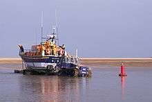
The current lifeboat station, housing both an all-weather lifeboat and an inshore rescue boat, is at the harbour entrance. The old lifeboat house, now used as the harbour offices, is at the western end of the quay. A new Shannon-class lifeboat is planned to replace the current boat in 2021 requiring a new much larger lifeboat station; the fate of the current station is uncertain.
In 1880, in the Wells lifeboat disaster, 11 of the 13 crew drowned, leaving 10 widows and 27 children without fathers. A memorial to the crew stands adjacent to the old lifeboat house.
Education
Schools in the town include Wells-Next-The-Sea Primary and Nursery School and Alderman Peel High School.[13][14] all are now part of the Wensum Trust which runs 24 schools in North Norfolk.
Beach
The Wells-next-the-Sea beach, being subject to the ever-changing tides of Holkham National Nature Reserve, makes use of an old war siren to warn patrons of incoming beach floodings. The siren sounds around 5–10 minutes before the tide is predicted to take over the beach to allow users to vacate the area safely.
Storms
Wells has been subject to flooding going back to the thirteenth century. In the twentieth century the notorious 1953 floods were followed by a surge almost as dangerous in 1978 for which the town was better prepared. On 5 December 2013, a storm surge occurred but did not affect the west end of the town because of a tidal barrier built in 1980. The Prime Minister, David Cameron, visited the town on 9 December to inspect the damage caused by flooding.[15]
Gallery
.jpg) Beached boat at Wells-next-the-Sea
Beached boat at Wells-next-the-Sea Signpost in Wells-next-the-Sea
 The Wells Harbour mouth from the sea wall; the lifeboat house can be seen in the distance
 Inland Wells, with view to Wells Harbour
 Looking out to the quay on a sunny August 2006 day
 The train from Wells arrives at Walsingham station
 Huts on the beach
 Grey seal on the beach
References
- Office for National Statistics & Norfolk County Council (2001). Census population and household counts for unparished urban areas and all parishes Archived 11 February 2017 at the Wayback Machine. Retrieved 2 December 2005.
- "Town population 2011". Retrieved 1 September 2015.
- Ordnance Survey (2002). OS Explorer Map 251 – Norfolk Coast Central. ISBN 0-319-21887-2.
- Description of Wells-next-the-Sea www.wellsnextthesea.info/Wellsonsea/WellsWeb/desc.html. Retrieved 28 November 2011.
- Nature Reserve : The Beach : Holkham Hall and Estate – North Norfolk, England www.holkham.co.uk/html/nature_reserve.html Archived 15 December 2014 at the Wayback Machine
- Pooley, Graham (1992). The Port of Wells: 1100 Years of History. ISBN 978-0-9516120-1-9.
- Arguile, Roger (2014). Wells next the Sea: a small port in a wide world. ISBN 978-1-909796-49-2.
- Favor Parker Shipping Register 23.11.81-31.12.86.
- Holkham National Nature Reserve holkham.co.uk/naturereserve/
- The house that May built, Eastern Daily Press, 28 November 2007
- Wellswalsinghamrailway.co.uk
- Wellsharbourrailway.co.uk
- Coulson, Tim (10 May 2016). "Warning notice to Wells-Next-The-Sea Primary and Nursery School". Gov.UK. Gov.UK. Retrieved 1 October 2018.
- "Alderman Peel High School". Find and compare schools in England. Gov.UK. Retrieved 1 October 2018.
- BBC news report Retrieved 10 December 2013
External links
| Wikivoyage has a travel guide for Wells-next-the-Sea. |
| Wikimedia Commons has media related to Wells-next-the-Sea. |
- Alderman Peel High School
- Wells web cam
- Wells-next-the-Sea information and visitor guide
- Map sources for Wells-next-the-Sea
- Tide tables for Wells-next-the-Sea.
- Photographs more details and interesting facts about Wells-next-the-Sea
- Gallery of Wells-next-the-Sea – Photographs of Wells-next-the-Sea
| Authority control |
|
|---|