Wearmouth Bridge
Wearmouth Bridge is a through arch bridge across the River Wear in Sunderland. It is the final bridge over the river before its mouth with the North Sea.
Wearmouth Bridge | |
|---|---|
 The current Wearmouth Bridge, constructed in 1929. The bridge in the background is the Monkwearmouth Railway Bridge and is still in use. | |
| Coordinates | 54.9097°N 1.3829°W |
| OS grid reference | |
| Carries |
|
| Crosses | River Wear |
| Locale | Wearside |
| Maintained by | Sunderland City Council |
| Heritage status | Grade II listed |
| Preceded by | Monkwearmouth Bridge |
| Characteristics | |
| Design | Through arch bridge |
| Material | Iron |
| Total length | 375 ft (114 m) |
| Width | 48 ft (15 m) |
| Longest span | 240 ft (73 m) |
| Clearance below | 105 ft (32 m) |
| No. of lanes |
|
| History | |
| Designer | Mott, Hay and Anderson |
| Constructed by | Sir William Arrol & Co. |
| Construction start | 1927 |
| Construction end | 1929 |
| Construction cost | £231,943 |
| Opened | 1929 |
| Inaugurated | 31 October 1929 |
 Wearmouth Bridge Location in Tyne and Wear | |
The current bridge is the third Wearmouth Bridge in its position. The first opened in 1796 and then was reconstructed in the 19th century.
History
The first bridge, 1796–1929
.jpg)

The first Wearmouth Bridge opened in 1796, with the foundation stone having been laid in September 1793. It was sponsored and patented by Rowland Burdon, the MP, designed by Thomas Paine, and built under the direction of Thomas Wilson, who designed its architectural features.[1] According to the plaque on the current bridge, its construction "proved to be a catalyst for the growth of Sunderland," since access between Monkwearmouth and Bishopwearmouth had previously only been by ferry, with the nearest bridge at Chester-le-Street. There was originally a toll for traffic and pedestrians, although tolls for pedestrians were abolished in 1846.
It was the second iron bridge built after the famous span at Ironbridge, but was over twice as long with a nominal span of 240 ft (73 m), and only three-quarters the weight. Indeed, at the time of building, it was the biggest single-span bridge in the world (72 m), matching the collapsed Trezzo Bridge.[2] It was considered one of the wonders of the industrial age. It opened to traffic on 9 August 1796, having cost a total of about £28,000.[3]
1805 repair and 1857 reconstruction
In 1805 the bridge had to be repaired after heat from the sun caused some of the cross tubes to fall out.[4]
From 1857 to 1859 it was reconstructed by Robert Stephenson, who stripped the bridge back to its six iron ribs and levelled the hump in its middle by raising the abutments. The bridge was reopened in March 1859, with the toll completely abolished in 1885.[3]
The current bridge, 1929–present
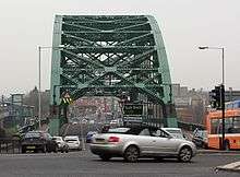
To accommodate the growing volume of traffic, construction began on the current bridge in 1927. It was designed by Mott, Hay and Anderson and fabricated by the famous bridge building firm of Sir William Arrol & Co. at their Dalmarnock Ironworks in Glasgow (they also built the famous Forth Rail Bridge and the steel structure of Tower Bridge in London).[5] The new bridge was built around the old one to allow the road to remain open.[4] It was opened on 31 October 1929 by the Duke of York (who would later become King George VI).[6]
The cost of the bridge amounted to £231,943 of which £12,000 was spent on dismantling the old bridge.[6]
The adjoining railway bridge was built in 1879, and extended the railway south from Monkwearmouth to the centre of Sunderland.[7]
The bridge carries the A183 road between Chester-le-Street and South Shields and the A1018 which was the old route of the A19 until the bypass was built leading to the Tyne Tunnel. It is a Grade II listed building.[8]
References
- Tyrrell, Henry Grattan : "History of Bridge Engineering", pp 153-154, 1911
- Leonardo Fernández Troyano: Bridge Engineering. A Global Perspective, Thomas Telford Publishing, London 2003, ISBN 0-7277-3215-3, p.49
- "Sunderland Wearmouth Bridge". Wearside Online. Archived from the original on 27 November 2011. Retrieved 24 September 2006.
- "LOCAL STUDIES CENTRE FACT SHEET NUMBER 7: The Wearmouth Bridge". Local Studies Centre collection, Sunderland Public Library Service. Archived from the original on 7 August 2011. Retrieved 30 January 2011.
- 'The Sir William Arrol Collection', Royal Commission on the Ancient and Historical Monuments of Scotland contains many pictures of Wearside Bridge under Construction
- Vickers, Alex. "The second Wearmouth Bridge". National Grid for Learning. Retrieved 24 September 2006.
- "Historic Structures: Wearmouth Bridge". Sunderland City Council. Archived from the original on 8 May 2005. Retrieved 24 September 2006.
- Historic England. "WEARMOUTH BRIDGE (1279911)". National Heritage List for England. Retrieved 19 June 2015.
External links
| Wikimedia Commons has media related to Wearmouth Bridge. |
| Next bridge upstream | River Wear | Next bridge downstream |
| Monkwearmouth Bridge Durham Coast Line & Tyne and Wear Metro |
Wearmouth Bridge Grid reference: NZ396574 |
None North Sea |