Vryburg
Vryburg (Afrikaans for free borough or free fortress) is a large agricultural town with a population of 48,200 situated in the Dr Ruth Segomotsi Mompati District Municipality of the North West Province of South Africa. It is the seat and the industrial and agricultural heartland of the district of the Bophirima region.
Vryburg | |
|---|---|
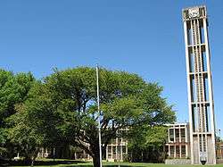 Vryburg town hall | |
 Vryburg  Vryburg | |
| Coordinates: 26°57′0″S 24°44′50″E | |
| Country | South Africa |
| Province | North West |
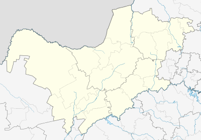
| District | Dr Ruth Segomotsi Mompati |
| Municipality | Naledi |
| Area | |
| • Total | 64.24 km2 (24.80 sq mi) |
| Population (2011)[1] | |
| • Total | 21,182 |
| • Density | 330/km2 (850/sq mi) |
| Racial makeup (2011) | |
| • Black African | 40.8% |
| • Coloured | 37.6% |
| • Indian/Asian | 3.2% |
| • White | 17.7% |
| • Other | 0.7% |
| First languages (2011) | |
| • Afrikaans | 56.3% |
| • Tswana | 33.0% |
| • English | 6.4% |
| • Other | 4.3% |
| Time zone | UTC+2 (SAST) |
| Postal code (street) | 8601 |
| PO box | 8600 |
| Area code | 053 |
Location
The town is situated halfway between Kimberley (the capital of the Northern Cape Province) and Mahikeng (the capital of the North West Province).
Vryburg is on Cecil Rhodes’s great northern railway, which ran from Cape Town through the Kimberley diamond fields, Vryburg, Mafeking, and northwards beyond the Victoria Falls. It is also on the N14 National Road which runs from Gauteng Province in a southwesterly direction through Vryburg, Kuruman and Upington to the mining town of Springbok in the north-western Cape. This road also connects Gauteng Province with Namibia.
The township of Huhudi (Tswana for “running water”) is situated just south of the town.
History
Capital of a Republic
The name Vryburg comes from the period in the 1882 when Vryburg was established as the capital of the Republic of Stellaland. The Republicans called themselves Vryburgers (“free citizens”), and since the Afrikaans word for “citizen” is burger and the word for “borough” (or “fortress”) is burg the name of the town followed.[2] The first and only president was G.J. van Niekerk. A site for the township was selected and named Endvogelfontein. On 15 November the same year, the name was changed to Vryburg. In December that year, newly laid out plots were apportioned to the volunteers by means of a lottery and by February 1883 some 400 farms had been established. On 16 August 1883, Administrator Van Niekerk proclaimed the Republic of Stellaland with Vryburg as capital and himself as President.
By 1884 the town consisted of about 20 houses.[3]
Stellaland split into two rival factions – those who supported annexation into the Cape Colony as mooted by Cecil Rhodes, and those who preferred independence.
British Bechuanaland
In February 1884, the London Convention was signed, making Stellaland a British protectorate, with the Reverend John McKenzie appointed Commissioner to British Bechuanaland.
In 1885, the British seized the town and incorporated the area into British Bechuanaland, which in turn became part of the Cape Colony in 1895.
Vryburg today is the industrial and agricultural capital of the Bophirima (Western) region.
Concentration Camp
During the Second Boer War, the British built a concentration camp here to house Boer women and children.
London Missionary Society
The Tiger Kloof Native Institute was set up south of the town by the London Missionary Society in 1904. A cornerstone for the building of the institute was laid in 1905 by the Earl of Selborne.[4] The stone church on the premises is a national monument.
Colony to Province
By 1910, the Cape Colony became the Cape Province, one of the four provinces of the Union of South Africa and later the Republic of South Africa. When nine provinces were established in 1994, Vryburg finally became part of the North West Province.
Economy
Beef production
Vryburg is South Africa's largest beef-producing district, with Bonsmara cattle the most popular. It is sometimes called "the Texas of South Africa".
Other produce
Maize and peanuts are important crops produced in the district. The town hosts South Africa's third largest agricultural show.
The town today is an industrial and agricultural hub. Its modern architecture blends naturally with its surroundings and the well-preserved old buildings are carefully maintained.
Transport
There are roads, rail and air connections to all the major centers in the country. Vryburg is also situated on the main railway line from Cape Town to Botswana and Zimbabwe.
The town is served by Vryburg Airport.
Culture
The Theiler Museum on the farm Armoedsvlakte, 8 km west of Vryburg, holds a collection of equipment used by Sir Arnold Theiler, the veterinarian who established the Onderstepoort veterinary research institute near Pretoria.
Fauna and flora
The Leon Taljaard Nature Reserve is located north west of the town with the Swartfontein resort located adjacent to the reserve. The reserve has a number of animal species including Rhino, Eland, Buffalo, Black Wildebeest, Waterbuck and Springbuck. It is open daily to the public.
See also
References
- "Main Place Vryburg". Census 2011.
- Appletons' annual cyclopaedia and register of important events of the year: 1896-1902. 3. 5. New York: Appletons. 1901. p. 3. Retrieved 2009-10-24.
- Great Britain (1884). South African Republic: A Convention Between Her Majesty the Queen of the United Kingdom of Great Britain and Ireland and the Republic of South Africa. London: Great Britain. p. 30. Retrieved 2009-10-24.
- Hawkins, Frank H (1914). "III - Tiger Kloof - "A Lamp Shining in a Dark Place"". Through lands that were dark : being a record of a year's missionary journey in Africa and Madagascar. London: London Missionary Society. p. 63. Retrieved 2009-10-24.
- Vryburg 1882-1982 Bornman, Hans (1982). Vryburg, 1882-1982. Vryburg: Stadsraad van Vryburg. ISBN 0620059885.
External links
Municipalities and communities of Dr Ruth Segomotsi Mompati District Municipality, North West | ||
|---|---|---|
District seat: Vryburg | ||
| Naledi | .svg.png) Dr Ruth Segomotsi Mompati District within South Africa | |
| Mamusa | ||
| Greater Taung | ||
| Lekwa-Teemane | ||
| Kagisano/Molopo | ||
| Authority control |
|
|---|