Villavicencio
Villavicencio (Spanish pronunciation: [biʎaβiˈsensjo]) is a city and municipality in Colombia. Capital of Meta Department, it was founded on April 6, 1840. The city had an urban population of approximately 531,275 inhabitants in 2018.[2] The city is located at 4°08'N, 73°40'W, 75 km (about 45 mi) southeast of the Colombian capital city of Bogotá (DC) by the Guatiquía River. It is the most important commercial center in the Llanos Orientales (Eastern plains). It has a warm and humid climate, with average daily temperatures ranging from 21 °C to 30 °C.2 It is affectionately called "Villavo" la bella.
Villavicencio | |
|---|---|
City | |
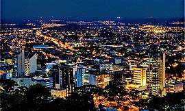   Center of Villavicencio | |
 Flag  Seal | |
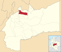 Location map of the municipality and city of Villavicencio in the Department of Meta. | |
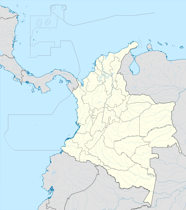 Villavicencio Location in Colombia | |
| Coordinates: 4°9′N 73°38′W | |
| Country | |
| Region | Orinoquía |
| Department | Department of Meta |
| Founded | 1840 |
| Government | |
| • Mayor | Juan Felipe Harman |
| Area | |
| • City | 1,328 km2 (513 sq mi) |
| Elevation | 467 m (1,532 ft) |
| Population (2018 Census[1]) | |
| • City | 531,275 |
| • Density | 400/km2 (1,000/sq mi) |
| • Urban | 492,052 |
| Demonym(s) | Villavicense |
| Time zone | UTC-05 (Eastern Time Zone) |
| Area code(s) | 57 + 8 |
| Climate | Af |
| Website | Official website (in Spanish) |
Lying in a rural zone of tropical climate, Villavicencio is on the great Colombian-Venezuelan plain called Los Llanos, which is situated to the east of the Andes mountains. Villavicencio is also called "La Puerta al Llano", or "The Gateway to the Plains", due to its location on the historical path from the Colombian interior to the vast savannas that lie between the Andes range and the Amazon rainforest.
Villavicencio's proximity to huge mountains and great plains make the city an example of Colombia's geodiversity. Because it is located in the foothills of the Andes, the morning and evening breezes cool the city, which is very hot for most of the day.
History
The German Conquistador Nikolaus Federmann reached the altiplano of Bogotá in 1536 by approaching it from the plains of Venezuela, a large unsettled area that is formed by the Orinoco basin. However, this vast area remained unexplored and uncolonized for the next 300 years. Colombia was settled along the mountainous folds of the Magdalena and Cauca valleys, and all of its commerce with the outside world was oriented towards the Caribbean Sea, thus, because of its mountainous barriers, the extreme heat, and inhospitable climate, the Llanos remained forgotten and unsettled.
The Llaneros, the inhabitants of the plains, are fierce horsemen who first fought for the Spanish royalists and then for the Venezuelan and Colombian rebels during the War of Independence. By crossing the Cordillera Oriental with Bolívar, they surprised the royalist army on the plains of Boyaca on the 6th of August, 1819, and cleared the way for the taking of an abandoned Santa Fe de Bogotá one week later. In the 1840s, some farmers from Caqueza, a town on the eastern folds of Bogotá, started the modest settlement of Gramalote, which officially became the parish of Villavicencio in 1855. The parish was named for Antonio Villavicencio, a patriot in the Colombian war of independence. Vaccines, a mule road, and the availability of vast areas of free land, drove new colonizers to continue the settlement of Villavicencio. As the roads improved the access to the Llanos, the farmers could send their produce and cattle to the markets of Bogotá.
After the assassination of Jorge Eliecer Gaitan, a popular Liberal politician in 1948, the large landowners saw a pretext to drive farmers out of their lands. The Llaneros resisted by driving the army out of population centers. The guerrillas never took Villavicencio, but they brought the fighting to the military base of Apiay. As the fighting between the government and the Llanero guerrillas was out of control, a military coup in June 1953, took Gustavo Rojas Pinilla to power who immediately negotiated a cease fire and amnesty for the insurgents.
1948–present
Villavicencio has grown from a small settlement of no more than 20 people in the 1850s to a settlement of over 400,000 inhabitants in 2011. A new road of bridges and tunnels has shortened the driving time to Bogotá from two or three hours, depending on the season of the year, to one and half hours to move the oil, cattle, and agricultural products faster.
Geography
The city is located in the Orinoquia Region, where the Oriental Plains begin. Most of the city's land is flat ground draining away from the Andes. The Guatiquia borders the city to the north and east. Caqueza and Chipaque are located northwest of Villavicencio. A true portal to the Llanos, the roads south of Villavo lead to Acacias and San Martin, the first historical town of the Llanos, which was an early Jesuit settlement. East of Villavo they point towards Apiay, Puerto Lopez and the fluvial port of Orocue on the Meta river, a strong affluent of the Orinoco.
Climate
Villavicencio has a Tropical rainforest climate. The climate is hot and sometimes humid, though its proximity to the foothills of the Oriental Andes brings mild breezes to the city at nightfall. Average temperatures is 27 degrees Celsius.
| Climate data for Villavicencio (La Vanguardia Airport) 1981–2010 | |||||||||||||
|---|---|---|---|---|---|---|---|---|---|---|---|---|---|
| Month | Jan | Feb | Mar | Apr | May | Jun | Jul | Aug | Sep | Oct | Nov | Dec | Year |
| Record high °C (°F) | 37.2 (99.0) |
39.5 (103.1) |
37.7 (99.9) |
37.5 (99.5) |
37.0 (98.6) |
35.5 (95.9) |
38.0 (100.4) |
36.0 (96.8) |
36.4 (97.5) |
36.9 (98.4) |
38.0 (100.4) |
37.5 (99.5) |
39.5 (103.1) |
| Average high °C (°F) | 31.6 (88.9) |
32.0 (89.6) |
31.4 (88.5) |
30.2 (86.4) |
29.5 (85.1) |
28.7 (83.7) |
28.5 (83.3) |
29.4 (84.9) |
30.3 (86.5) |
30.5 (86.9) |
30.4 (86.7) |
30.7 (87.3) |
30.3 (86.5) |
| Daily mean °C (°F) | 26.7 (80.1) |
27.2 (81.0) |
26.8 (80.2) |
25.7 (78.3) |
25.2 (77.4) |
24.5 (76.1) |
24.2 (75.6) |
24.9 (76.8) |
25.5 (77.9) |
25.6 (78.1) |
25.6 (78.1) |
25.9 (78.6) |
25.6 (78.1) |
| Average low °C (°F) | 21.3 (70.3) |
22.0 (71.6) |
22.2 (72.0) |
21.6 (70.9) |
21.2 (70.2) |
20.7 (69.3) |
20.3 (68.5) |
20.5 (68.9) |
20.6 (69.1) |
20.9 (69.6) |
21.2 (70.2) |
21.0 (69.8) |
21.1 (70.0) |
| Record low °C (°F) | 15.0 (59.0) |
16.0 (60.8) |
18.0 (64.4) |
18.0 (64.4) |
16.0 (60.8) |
15.0 (59.0) |
15.0 (59.0) |
15.0 (59.0) |
16.5 (61.7) |
15.0 (59.0) |
16.0 (60.8) |
16.0 (60.8) |
15.0 (59.0) |
| Average precipitation mm (inches) | 63.0 (2.48) |
132.2 (5.20) |
230.4 (9.07) |
520.2 (20.48) |
673.8 (26.53) |
541.6 (21.32) |
460.6 (18.13) |
399.6 (15.73) |
406.8 (16.02) |
498.9 (19.64) |
424.5 (16.71) |
186.3 (7.33) |
4,537.8 (178.65) |
| Average precipitation days | 9 | 11 | 16 | 24 | 27 | 27 | 28 | 25 | 22 | 24 | 22 | 15 | 250 |
| Average relative humidity (%) | 68 | 65 | 71 | 79 | 82 | 83 | 82 | 79 | 77 | 79 | 80 | 75 | 77 |
| Mean monthly sunshine hours | 170.5 | 132.8 | 111.6 | 111.0 | 120.9 | 111.0 | 114.7 | 136.4 | 153.0 | 161.2 | 147.0 | 164.3 | 1,634.4 |
| Mean daily sunshine hours | 5.5 | 4.7 | 3.6 | 3.7 | 3.9 | 3.7 | 3.7 | 4.4 | 5.1 | 5.2 | 4.9 | 5.3 | 4.5 |
| Source: Instituto de Hidrologia Meteorologia y Estudios Ambientales[3][4][5] | |||||||||||||
Economy
Cattle, agriculture, and the exportation of crude oil fuel the Villavicencio economy. Imports from the surrounding area include coffee, bananas, and rice.
La Vanguardia Airport serves Villavicencio with flights to the rest of Colombia on four airlines, including Colombian major airlines Avianca and Latam Colombia.
Education
University of the Llanos is a public university located Villavicencio. Other higher education institutions include Cooperative University of Colombia, Saint Thomas Aquinas University, Saint Martin University, Uniminuto, UAN.
Sports
The city has a football (soccer) team, the Llaneros futbol club which plays in Colombia's second division.
The Colombian Football Federation announced that Villavicencio will be one of the venue cities to host the 2016 FIFA Futsal World Cup.[6]
Tourism
To the natural possibilities that its territory offers for the rest, the works of modernization of the highway are added that shortened in distance and time the passage with the capital of the Republic. In this way Villavicencio and other adjacent municipalities (Acacías, Cumaral, Restrepo, Puerto Lopéz, Puerto Gaitán, Cáqueza) are offered as new tourist destinations. In preparation to meet this demand, tourism development plans and strategies are implemented by the departmental and municipal governments, as well as the Cotelco branch. In relation to physical infrastructure, the city has an acceptable hotel inventory, as well as agro-tourism properties.
Culture
Villavicencio shares the condition of land of immigrants with the region of the Eastern Plains of Colombia; from its foundation to the present, people from the interior of the country and the coasts have sought and found in the city the conditions and the receptivity to establish themselves; At the same time, they have contributed to forge a mestizo culture in which, nevertheless, they struggle to impose a stronger relationship with the region, a bond of identity with the llanera culture. Mamona, coleo, cockfighting, joropo, dance, legends, myth, the renewed and popularized use of the poncho, among others are currently struggling not to disappear before the thrust of urban or modern life. Folklore is made up of the traditional customs of the people.
Gastronomy
In Villavicencio the typical dishes are in turn representative of the gastronomy of the Eastern Plains.
Meat to the llanera (mamona or veal)
Veal roasted in wood and marinated only with salt and beer. It is served with cassava, potatoes and plantains; optionally it is accompanied with a stew or sauce based on chili and a beer or lemonade based on panela. In the city there is a wide variety of restaurants and grills that offer several typical dishes of the region. This is the most representative dish of the Llanos region, in such a way that it can be found in other parts of the country.
Arepas and breads
Rice arepas, rice bread, cassava bread, corn and corn wrapped, tungos, fish dish, three-phase sancocho, pâté broth, minced soup, pajarilla broth.
Rice bread
The rice bread is a snack made with rice and curd which is currently carrying a special safeguard plan before the Ministry of Culture of Colombia and also through the Association of bread producers and marketers of Rice Meta ( ASPAMET) with the help of the Chamber of Commerce of Villavicencio, are promoting the product to aspire to have a designation of origin before the Superintendence of Industry and Commerce of Colombia, rice bread is an important link in the cuisine of Villavicencio, currently is the municipality where this food is sold the most locally, nationally and internationally, the most traditional bakery and former rice bread producer is Rosquipan since 1990.
Drinks
Guarulo, Masato, Lemonade with panela, Guarapo de Piña and the coffee cerrero. In addition to the typical liquors such as Aguardiente Llanero and Ron San Martín Añejo.
Born in Villavicencio
- Cato Manuel Ekrene, Norwegian film director
- Carolina Gaitán, Colombian television actress
- William Pulido, former professional cyclist
- Óscar Ruiz, former football referee and lawyer
- Henrry Sanchez, psychologist
- Nathalia Sánchez, gymnast
- Kelly Drake, Nurse
References
- https://www.dane.gov.co/files/varios/informacion-capital-DANE-2019.pdf
- https://www.dane.gov.co/files/varios/informacion-capital-DANE-2019.pdf
- "Promedios Climatológicos 1981–2010" (in Spanish). Instituto de Hidrologia Meteorologia y Estudios Ambientales. Archived from the original on 15 August 2016. Retrieved 16 August 2016.
- "Promedios Climatológicos 1971–2000" (in Spanish). Instituto de Hidrologia Meteorologia y Estudios Ambientales. Archived from the original on 15 August 2016. Retrieved 16 August 2016.
- "Tiempo y Clima" (in Spanish). Instituto de Hidrologia Meteorologia y Estudios Ambientales. Archived from the original on 15 August 2016. Retrieved 16 August 2016.
- "Copa Mundial de Futsal de la FIFA se jugará en Colombia en 2016". http://fcf.com.co/. 28 May 2013. Archived from the original on 3 December 2013. Retrieved 28 May 2013. External link in
|publisher=(help)