Verona, Kentucky
Verona is an unincorporated community and census-designated place (CDP) in Boone County, Kentucky, United States. The population was 1,455 at the 2010 census.[1]
Verona, Kentucky | |
|---|---|
Census-designated place (CDP) | |
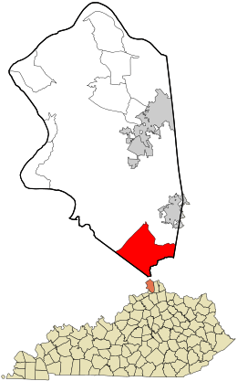 Location within Boone County and the state of Kentucky | |
| Coordinates: 38°49′5″N 84°39′38″W | |
| Country | United States |
| State | Kentucky |
| County | Boone |
| Area | |
| • Total | 12.3 sq mi (31.9 km2) |
| • Land | 12.2 sq mi (31.7 km2) |
| • Water | 0.08 sq mi (0.2 km2) |
| Elevation | 900 ft (300 m) |
| Population (2010) | |
| • Total | 1,455 |
| • Density | 119/sq mi (45.9/km2) |
| Time zone | UTC-5 (Eastern (EST)) |
| • Summer (DST) | UTC-4 (EDT) |
| ZIP code | 41092 |
| Area code(s) | 859 |
| FIPS code | 21-79464 |
| GNIS feature ID | 0506026 |
History
It has been stated that details regarding the community's settlement and its founders are unknown.[2]
In its earlier times, Verona was "a thriving business community surrounded by farmlands".[2] The community had a building supply store, a blacksmith, a bank, a creamery, grocery stores, a dry goods store, saloons, tobacco shops, a barber shop, a funeral home, a jail and a post office.[2] The community's post office was opened on March 24, 1834, and Verona was incorporated as a city in 1909.[2] The city's incorporation later dissolved when the community's leadership became dormant.[2] The Verona High School was established in 1914.[2]
Geography
The Verona CDP occupies the southern corner of Boone County, bordered by Interstate 71 to the northwest, by the Gallatin County line to the southwest, and by the Grant County line, following Bullock Pen Creek, to the south. The original hamlet of Verona is located at the intersection of Kentucky Routes 14 and 16, but the CDP includes a larger rural area surrounding the hamlet. It is 6 miles (10 km) northeast along Routes 14/16 to Walton and 27 miles (43 km) north to downtown Cincinnati.Walton has the middle and highschool of Walton Verona, verona has the elementary
According to the United States Census Bureau, Verona has a total area of 12.3 square miles (31.9 km2), of which 12.2 square miles (31.7 km2) is land and 0.077 square miles (0.2 km2), or 0.76%, is water.[1]
References
- "Geographic Identifiers: 2010 Demographic Profile Data (G001): Verona CDP, Kentucky". U.S. Census Bureau, American Factfinder. Archived from the original on February 12, 2020. Retrieved November 21, 2013.
- Tenkotte, P.A.; Claypool, J.C. (2015). The Encyclopedia of Northern Kentucky. EBSCO ebook academic collection. University Press of Kentucky. pp. 911–912. ISBN 978-0-8131-5996-6. Retrieved September 22, 2018.
Municipalities and communities of Boone County, Kentucky, United States | ||
|---|---|---|
| Cities | 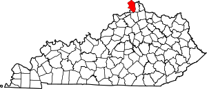 Location of Boone County, Kentucky | |
| CDPs | ||
| Unincorporated Communities | ||
| Ghost town | ||
| Footnotes | ‡This populated place also has portions in an adjacent county or counties. | |