Belleview, Kentucky
Belleview is an unincorporated community and census-designated place (CDP) in Boone County, Kentucky, United States.[1] The population was 343 at the 2010 census.[2]
Belleview, Kentucky | |
|---|---|
Census-designated place (CDP) | |
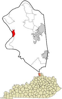 Location within Boone County and the state of Kentucky | |
| Coordinates: 38°59′10″N 84°49′32″W | |
| Country | United States |
| State | Kentucky |
| County | Boone |
| Area | |
| • Total | 1.9 sq mi (4.8 km2) |
| • Land | 1.4 sq mi (3.5 km2) |
| • Water | 0.5 sq mi (1.3 km2) |
| Elevation | 509 ft (155 m) |
| Population (2010) | |
| • Total | 343 |
| • Density | 252/sq mi (97.4/km2) |
| Time zone | UTC-5 (Eastern (EST)) |
| • Summer (DST) | UTC-4 (EDT) |
| Area code(s) | 859 |
| FIPS code | 21-05428 |
| GNIS feature ID | 0486809 |
Geography
Belleview is located in western Boone County along the Ohio River, 24 miles (39 km) southwest of downtown Cincinnati. Kentucky Route 18 (Burlington Pike) runs east from Belleview 7 miles (11 km) to Burlington (the Boone County seat) and 13 miles (21 km) to Florence.
According to the United States Census Bureau, Belleview has a total area of 1.9 square miles (4.8 km2), of which 1.4 square miles (3.5 km2) is land and 0.50 square miles (1.3 km2), or 26.99%, is water, consisting of the Ohio River out to its centerline, which is the border with Indiana.[2]
Belleview is the location of six places listed on the U.S. National Register of Historic Places:
- Belleview Baptist Church
- Belleview Post Office
- Clore House
- Jonas Clore House
- Flick House
- James Rogers House
References
- "Find a County". National Association of Counties. Archived from the original on 2012-07-12. Retrieved 2011-06-07.
- "Geographic Identifiers: 2010 Demographic Profile Data (G001): Belleview CDP, Kentucky". U.S. Census Bureau, American Factfinder. Archived from the original on February 12, 2020. Retrieved November 20, 2013.
Municipalities and communities of Boone County, Kentucky, United States | ||
|---|---|---|
| Cities | 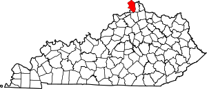 Location of Boone County, Kentucky | |
| CDPs | ||
| Unincorporated Communities | ||
| Ghost town | ||
| Footnotes | ‡This populated place also has portions in an adjacent county or counties. | |