Van Diemen Gulf
Van Diemen Gulf is a gulf in the Northern Territory of Australia which connects to the Timor Sea in the north via Dundas Strait. It is also connected to the Beagle Gulf in the west by the Clarence Strait. It covers an area of about 14,000 square kilometres (5,400 sq mi).
| Van Diemen Gulf | |
|---|---|
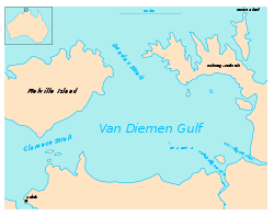 Map showing the layout of Van Diemen Gulf. Darwin is in lower left corner. | |
| Coordinates | 11°49′S 131°57′E |
| Type | Gulf |
| Etymology | Anthony van Diemen.[1] |
| Basin countries | Australia |
| Max. length | 75 nautical miles (139 km; 86 mi) [2] |
| Max. width | 45 nautical miles (83 km; 52 mi) [2] |
Rivers draining into the Gulf include the South Alligator River, the East Alligator River and the Adelaide River. The Kakadu National Park adjoins its south-east coast .
Administrative status
On 4 April 2007, most of the area occupied by the Van Diemen Gulf was gazetted as a locality with the name, Van Diemen Gulf by the Northern Territory Government who also included it in the local government area of the West Arnhem Region.[3][4][5]
References
- "Place Names Register Extract - "Van Diemen Gulf"". NT Place Names Register. Northern Territory Government. Retrieved 1 May 2019.
- Sailing Directions (Enroute), Pub. 175: North, West, and South Coasts of Australia (PDF). Sailing Directions. United States National Geospatial-Intelligence Agency. 2017. p. 27.
- "Place Names Register Extract - "Van Diemen Gulf" (locality)". NT Place Names Register. Northern Territory Government. Retrieved 27 April 2019.
- "Extent of the locality of "Van Diemen Gulf"". NT Atlas and Spatial Data Directory. Northern Territory Government. Retrieved 27 April 2019.
- "Localities within West Arnhem Shire (sic)" (PDF). Place Names Committee. Northern Territory Government. 2 April 2007. Retrieved 27 April 2019.

This article is issued from Wikipedia. The text is licensed under Creative Commons - Attribution - Sharealike. Additional terms may apply for the media files.