Valapattanam
Valapattanam is a small town in the Kannur district, located in the Indian state of Kerala. It is also the smallest panchayath in Kerala.Its area is 2.04 sqr Km. It is about 7 km north of Kannur. Valapattanam is an important Muslim settlement area in Kannur. Valapattanam is known for its communal harmony. On one side Kalarivathukkal Temple is located and on the other bank there is "Kakkulangara Mosque".
Valapattanam | |
|---|---|
Town | |
 Muchilottu Bhagavathi Theyyam | |
| Coordinates: 11.9°N 75.37°E | |
| Country | |
| State | Kerala |
| District | Kannur |
| Government | |
| • Type | Panchayath |
| • Body | Valapattanam Grama Panchayath |
| Elevation | 6 m (20 ft) |
| Population (2001) | |
| • Total | 8,369 |
| Languages | |
| • Official | Malayalam, English |
| Time zone | UTC+5:30 (IST) |
| ISO 3166 code | IN-KL |
.jpg)
.jpg)

Etymology
This town is also known as Balyapattanam. This town is in the on the banks of Valapattanam river Centuries back Valapattanam River (വളപട്ടണം പുഴ ) was the main ship route for trading and Valapattanam was the main town, because of this the town got this referred as "Valya pattanam" which means "big town" in Malayalam language.
History
This town is named after its historical founder Vallabha II of the Mooshika dynasty (Kolathiri family) and was originally known as Vallabha-Pattanam [1] and served as the capital of the Mooshika dynasty during the medieval ages. The fourteenth-century narrative of Ibn Battuta refers to the ruler of Ezhimala as residing at Baliapatanam[2] and offers a clue that by this time, the centre of the political authority had shifted from Ezhimala to Baliapatanam. It is also possible that the 'Budfattan' visited by Abraham Ben Yiju, a Jewish merchant who lived in Mangalore in the 1230s and 1240s, was also Valapattanam.[3] In the sixteenth century AD, a Portuguese official Duarte Barbosa also mentions Baliapatanam (Baliapatam in European records) as the residence of the ‘king of Cannanore’.
Commerce
Western India Plywoods Ltd., the largest wood-based industry in the country and once Asia's biggest plywood factory is located on the bank of Valapattanam River. Apart from the dense presence of booming plywood and timber based industries, Valapattanam is famous for small scale sand mining and fisheries activities. Warehouses of many prominent industries in Kannur is situated at Valapattanam.
Religion
Known for its communal harmony and tradition of peaceful coexistence, numerous religious centers with centuries of tradition is located here.
The famous Muthappan temple is on the bank of Valapattanam river.
Geography
Valapattanam is located at 11.9°N 75.37°E.[4] It has an average elevation of 6 metres (19 feet).
Suburbs and Villages
- Manna,Valappattanam
.jpg)
Demographics
As of 2001 India census,[5] Valapattanam had a population of 8369. Males constitute 50% of the population and females 50%. Valapattanam has an average literacy rate of 81%, higher than the national average of 59.5%: male literacy is 83%, and female literacy is 79%. In Valapattanam, 14% of the population is under 6 years of age.
Images
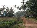 Village footpath
 Coconut in serenity
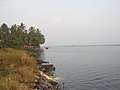 Poithum Kadavu
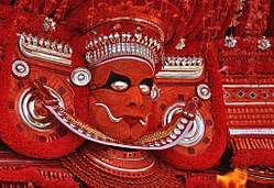
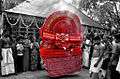 Kaliyattam at Valapattanam
Valapattanam Panchayath is rated among the best panchayaths in Kerala. The development activities of the panchayat has been commended by both the district and state authorities, as well as the public at large.
See also
- Muthappan temple
- Sree Muthappan
- Kannur
References
- Ezhimala: the abode of the Naval Academy by Murkot Ramunny in 1993, Northern Book Centre, New Delhi
- The Rehla of Ibn Battuta (India, Maldive Islands and Ceylon), tr. and commentary by Mahdi Husain (Baroda: Oriental Institute, 1953), 186.
- Amitav Ghosh, In an Antique Land (Gurgaon: Penguin Random House India, 2009) [first publ. Ravi Dayal 1992), pp. 233-35; ISBN 9780143066491.
- Falling Rain Genomics, Inc - Valapattanam
- "Census of India 2001: Data from the 2001 Census, including cities, villages and towns (Provisional)". Census Commission of India. Archived from the original on 16 June 2004. Retrieved 1 November 2008.
External links
| Wikimedia Commons has media related to Valapattanam. |