Urmia Lake Bridge
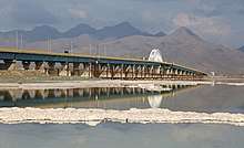
The Urmia Lake Bridge or Urmia Lake Causeway is a road bridge in northern Iran. It is the largest and longest bridge in Iran, and crosses Lake Urmia, connecting the provinces of East Azerbaijan and West Azerbaijan. The project was completed in November 2008.
The bridge reduced the driving distance between Tabriz and Urmia by 135 kilometres (84 mi), saving time and fuel consumption, and reducing road accidents. It has helped stimulate cultural exchanges, tourism and trade between the provinces of East Azerbaijan and West Azerbaijan.
History
A project to build a highway across the lake was initiated in the 1970s but was abandoned after the Iranian Revolution of 1979, although a 15 km (9.3 mi) causeway with an unbridged gap had already been completed. The project was revived in the early 2000s, and was completed in November 2008 with the opening of the bridge across the remaining gap.[1]
The bridge was planned for the length of 1,276 meters with 19 spans, comprising a central 100 meter main span and nine spans each side. The main span is in the form of an overhead tied arch and is 20.1 meters in height. It allows for shipping underneath.
The highly saline environment is already causing heavy rusting of the steel on the bridge, despite anti-corrosion treatment.
Synthetic Aperture Radar imagery
Multisensor InSAR analysis from 4 different satellite sensors (i.e. Envisat, ALOS-1, TerraSAR-X and Sentinel-1) in a period of 13 years (2004-2017) revealed that a long-term consolidation on the causeway is present. The rate of consolidation (in satellite's look direction) of the causeway peaked at 90 mm/year between 2012 and 2013. The soil consolidation of the causeway is not unusual, but if the settlement that has occurred since 2004 continues into the future, the causeway might be damaged by uneven settlement rates in the east and west embankments.[2]
Environmental impact
Environmentalists have warned that the construction of the causeway for the bridge, along with other ecological factors, will contribute to the drying up of Lake Urmia, turning it into an inland salt marsh, and adversely affecting the climate of the region. They state that the 1,276 metres (4,186 ft) gap in the causeway is not wide enough to permit and adequate flow between the two portions of the lake.[3] The presence of increased numbers of halobacteriaceae in the northern portion of the lake is indicative of the increasing salinity of the water.[4]
Footnotes
- Iran's East and West Azarbaijan provinces connected by Lake Orumiyeh bridge
- "Spatiotemporal deformation patterns of the causeway as characterized by multisensor InSAR analysis". Nature.
- Khosravifard, Sam (26 April 2010) "Campaigners Fear Lake Urmia Drying Up" IRN Issue 33, Institute for War and Peace Reporting; archived here by Internet Archive on 10 June 2010
- Mohebbi, Fereidun et al. (2011) "On the red coloration of Urmia Lake (Northwest Iran)" International Journal of Aquatic Science 2(1): pp. 88–92; archived at https://www.webcitation.org/65zgrKW6v by WebCite on 7 March 2012
External links
| Wikimedia Commons has media related to Lake Urmia bridge. |
.jpg)