Untersiemau
Untersiemau is a municipality in the district of Coburg in Bavaria in Germany.
Untersiemau | |
|---|---|
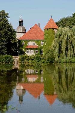 Castle in the town | |
 Coat of arms | |
Location of Untersiemau within Coburg district 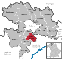 | |
 Untersiemau  Untersiemau | |
| Coordinates: 50°11′39″N 10°58′23″E | |
| Country | Germany |
| State | Bavaria |
| Admin. region | Oberfranken |
| District | Coburg |
| Government | |
| • Mayor | Rolf Rosenbauer (CSU) |
| Area | |
| • Total | 20.49 km2 (7.91 sq mi) |
| Elevation | 299 m (981 ft) |
| Population (2018-12-31)[1] | |
| • Total | 4,148 |
| • Density | 200/km2 (520/sq mi) |
| Time zone | CET/CEST (UTC+1/+2) |
| Postal codes | 96253 |
| Dialling codes | 09565 |
| Vehicle registration | CO |
| Website | www.untersiemau.de |
Geography
Location
Untersiemau lies about 10 kilometres (6.2 miles) south of Coburg at the eastern edge of Itz Valley.
Subdivisions
Untersiemau is divided into 9 Ortsteile:
- Birkach am Forst
- Haarth
- Meschenbach
- Obersiemau
- Scherneck
- Stöppach
- Untersiemau
- Weißenbrunn am Forst
- Ziegelsdorf
History
Untersiemau was first mentioned about 800 as Suome, the name is of Slavic origin.[2]
Transport
Untersiemau can be reached by car via motorway A 73 Suhl-Coburg-Nuremberg. Untersiemau used to have a station at the Itz Valley Railway, which was lifted in 2005.
References
- "Fortschreibung des Bevölkerungsstandes". Bayerisches Landesamt für Statistik und Datenverarbeitung (in German). July 2019.
- Debus, Arno. 1200 Jahre Untersiemau (in German).
Towns and municipalities in Coburg (district) | ||
|---|---|---|
Coat of Arms of Coburg district | ||
| Authority control |
|
|---|
This article is issued from Wikipedia. The text is licensed under Creative Commons - Attribution - Sharealike. Additional terms may apply for the media files.