Ua Huka
Ua Huka is one of the Marquesas Islands, in French Polynesia, an overseas territory of France in the Pacific Ocean. It is situated in the northern group of the archipelago, approximately 25 mi (40 km) to the east of Nuku Hiva, at 8°54′S 139°33′W.
Ua-Huka | |
|---|---|
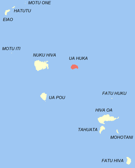 Location of the commune (in red) within the Marquesas Islands | |
Location of Ua-Huka 
| |
| Coordinates: 8°54′S 139°33′W | |
| Country | France |
| Overseas collectivity | French Polynesia |
| Subdivision | Marquesas Islands |
| Government | |
| • Mayor (2014-2020) | Nestor Ohu |
| Area 1 | 83.4 km2 (32.2 sq mi) |
| Population (2017) | 674 |
| • Density | 8.1/km2 (21/sq mi) |
| Time zone | UTC−09:30 |
| INSEE/Postal code | 98756 /98744 |
| Elevation | 0–857 m (0–2,812 ft) |
| 1 French Land Register data, which excludes lakes, ponds, glaciers > 1 km2 (0.386 sq mi or 247 acres) and river estuaries. | |
Name
Ua Huka is sometimes also found spelled Roohka or Ua Huna. The first Western navigator to sight the island was U.S. Navy Capt. Joseph Ingraham in 1791. He named the island "Washington Island" in honor of U.S. President George Washington, a name which was eventually extended to include all of the northern group of the Marquesas Islands. Other names for the island include Riou and Solide. See also Names of the Marquesas Islands. The spider genus Uahuka is named after this island.
History
Although Ua Huka is located in the northern Marquesas, historically, culturally and linguistically the island's tribes were far more closely aligned with the southern Marquesas Islands, especially with the tribes from Pepane, in the eastern half of Hiva Oa.
Geography
The island is shaped approximately like a crescent, with its concave edge facing the south. The land area is approximately 83 km² (32 sq. mi.). The center of the island is a high plateau, deeply indented in places by narrow river valleys. The highest peak, Hitikau reaches an elevation of 884 metres (2,900 ft). Much of the island's native plant cover, which outside the valleys consists primarily of dryland scrub, has been devastated by herds of feral goats and horses, which are estimated to number upwards of 3,000.
Ua Huka is a shield volcano that was emplaced between 2.2 and 2.4 million years ago. It is thought to have formed by a center of upwelling magma called the Marquesas hotspot. The island is served by Ua Huka Airport.
Administration
Administratively Ua Huka forms the commune (municipality) of Ua-Huka, part of the administrative subdivision of the Marquesas Islands.[1] This commune consists solely of the island of Ua Huka itself.[2]
The administrative centre of the commune is the settlement of Hane.[2]
Demography
Its population was 674 at the 2017 census.[3] There are three villages: Vaipaee, Hane, and Hokatu.
Population
| Historical population | ||
|---|---|---|
| Year | Pop. | ±% |
| 2002 | 582 | — |
| 2007 | 570 | −2.1% |
| 2012 | 621 | +8.9% |
| 2017 | 678 | +9.2% |
Economy
Although the primary economic activity remains the production of copra, Ua Huka has rich resources for tourism, including restorations of various archæological sites, museums displaying the former glory of Marquesan civilization, and the preservation of the island's unique flora. Among the archæological remains at sites such as Tehavea and Meiaute are ancient petroglyphs and thousands of bird bones.[4] The Pupuakeiha Arboretum consists of 42 acres (17 ha) planted with over 300 species of trees. It is hoped that one day this wealth of species will be able to be used to reforest the island. On the western end of the island are found a number of sea-caves.
References
- Décret n° 2005-1611 du 20 décembre 2005 pris pour l'application du statut d'autonomie de la Polynésie française, Légifrance
- Décret n°72-407 du 17 mai 1972 portant création de communes dans le territoire de la Polynésie française, Légifrance
- Répartition de la population en Polynésie française en 2017, Institut de la statistique de la Polynésie française
- Reaka-Kudla, Marjorie L.; Wilson, Don E.; Wilson, Edward O. (30 September 1996). Biodiversity II: Understanding and Protecting Our Biological Resources. Joseph Henry Press. p. 150. ISBN 978-0-309-52075-1.
| Wikimedia Commons has media related to Ua Huka. |
| Northern Marquesas: | |||
|---|---|---|---|
| Southern Marquesas: | |||
| Authority control |
|
|---|