Tumucumaque Mountains National Park
The Tumucumaque Mountains National Park (Portuguese: Parque Nacional Montanhas do Tumucumaque; Portuguese pronunciation: [tumukuˈmaki]) is situated in the Amazon Rainforest in the Brazilian states of Amapá and Pará. It is bordered to the north by French Guiana and Suriname.
| Tumucumaque Mountains National Park | |
|---|---|
IUCN category II (national park) | |
 | |
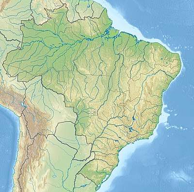 | |
| Location | Amapá, Pará, Brazil |
| Coordinates | 1°50′N 54°0′W |
| Area | 38,874 km2 (15,009 sq mi) |
| Established | August 23, 2002 |
History
Tumucumaque was declared a national park on August 23, 2002, by the Government of Brazil, after collaboration with the WWF.[1] It is part of the Amapá Biodiversity Corridor, created in 2003.[2] The conservation unit is supported by the Amazon Region Protected Areas Program.[3]
Geography
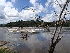
Tumucumaque Mountains National Park has an area of more than 38,800 square kilometres (14,980 sq mi), making it the world's largest tropical forest national park and larger than Belgium.[4] This area even reaches 59,000 square kilometres (22,780 sq mi) when including the bordering Guiana Amazonian Park, a national park in French Guiana. This combination of protected areas is still smaller than the three national parks system in the Brazil-Venezuelan border, where the Parima-Tapirapeco, Serranía de la Neblina and Pico da Neblina national parks have a combined area of over 73,000 square kilometres (28,190 sq mi).
But the latter is certainly smaller if the Tumucumaque Mountains National Park (Brazil) and the adjacent Guiana Amazonian Park (France) is combined with large neighbouring protected areas in northern Pará, Brazil, such as Grão-Pará Ecological Station, Maicuru Biological Reserve, and many others. The importance is that this makes the Guiana Shield one of the best protected and largest ecological corridor of tropical rainforests in the world. It is an uninhabited region and is of high ecological value: most of its animal species, mainly fish and aquatic birds, are not found in any other place in the world. It is a habitat for jaguars, primates, aquatic turtles, and harpy eagles.[5]
The highest point of the Brazilian state of Amapá is located there, reaching 701 meters.[6]
Climate
The climate is tropical monsoon (Köppen: Am), common in areas of northern Brazil in transition from biomes to the Amazon Forest.[7] It has an average temperature of 25 °C (77 °F) and accumulated rainfall ranging from 2,000 (7.87 in) to 3,250 mm (127.95 in) per year.[8]
| Climate data for Tumucumaque Mountains National Park (border with Suriname), elevation: 325 m or 1,066 ft, 1961-1990 normals and extremes | |||||||||||||
|---|---|---|---|---|---|---|---|---|---|---|---|---|---|
| Month | Jan | Feb | Mar | Apr | May | Jun | Jul | Aug | Sep | Oct | Nov | Dec | Year |
| Average high °C (°F) | 29.0 (84.2) |
28.8 (83.8) |
29.2 (84.6) |
29.4 (84.9) |
29.5 (85.1) |
29.6 (85.3) |
29.9 (85.8) |
30.8 (87.4) |
31.7 (89.1) |
32.2 (90.0) |
31.6 (88.9) |
30.3 (86.5) |
30.2 (86.3) |
| Daily mean °C (°F) | 24.2 (75.6) |
24.1 (75.4) |
24.3 (75.7) |
24.5 (76.1) |
24.5 (76.1) |
24.4 (75.9) |
24.4 (75.9) |
24.7 (76.5) |
25.2 (77.4) |
25.8 (78.4) |
25.7 (78.3) |
25.0 (77.0) |
24.7 (76.5) |
| Average low °C (°F) | 20.7 (69.3) |
20.8 (69.4) |
21.0 (69.8) |
21.4 (70.5) |
21.3 (70.3) |
21.0 (69.8) |
20.7 (69.3) |
20.6 (69.1) |
20.4 (68.7) |
20.9 (69.6) |
21.0 (69.8) |
21.0 (69.8) |
20.9 (69.6) |
| Average precipitation mm (inches) | 111.2 (4.38) |
116.3 (4.58) |
168.1 (6.62) |
226.7 (8.93) |
348.5 (13.72) |
231.1 (9.10) |
189.4 (7.46) |
105.8 (4.17) |
76.9 (3.03) |
38.4 (1.51) |
43.8 (1.72) |
75.9 (2.99) |
1,732.1 (68.21) |
| Average relative humidity (%) | 84.0 | 84.0 | 85.0 | 85.0 | 87.0 | 85.0 | 85.0 | 82.0 | 76.0 | 74.0 | 75.0 | 79.0 | 81.8 |
| Mean monthly sunshine hours | 121.7 | 109.6 | 112.0 | 104.0 | 129.7 | 165.8 | 171.5 | 207.3 | 218.9 | 220.4 | 199.4 | 163.8 | 1,924.1 |
| Source: NOAA[9] | |||||||||||||
Legacy
Mozilla Firefox code-named the beta of Firefox 4 Tumucumaque.[10]
References
- "Brazil creates largest tropical park". NBC News / AP. Aug 22, 2003. Retrieved 23 August 2015.
- Corredor de Biodiversidade do Amapá Biodiversity Corridor, p. 43.
- Full list: PAs supported by ARPA.
- "Brazil creates largest rainforest reserve". BBC News. 23 August 2002. Retrieved 23 August 2015.
- "World's largest tropical forest park created". New Scientist. 22 August 2002. Retrieved 23 August 2015.
- Portal Brasil
- Hunter, Allice (2018-11-21), English: Köppen climate types of Pará, Brazil., retrieved 2019-03-26
- "Parque Nacional do Tumucumaque, Amapá". web.archive.org. Amazônia de A a Z - Portal Amazônia. 2016-03-14. Retrieved 2019-03-26.
- "Tirios Region (82026) - WMO Weather Station". NOAA. Retrieved March 24, 2019.
- https://www.mozilla.org/parks/tumucumaque/ Archived 2011-06-29 at the Wayback Machine
Sources
- Corredor de Biodiversidade do Amapá Biodiversity Corridor (PDF), Belém: CI-Brasil, Governo do Amapá, Fundação Lee & Gund, 2007, retrieved 2016-11-05
- Full list: PAs supported by ARPA, ARPA, retrieved 2016-08-07
External links
- Amazon natives use Google Earth, GPS to protect rainforest home
- Conservation International - Mountains of Tumucumaque Mountains National Park: Setting a New Conservation Standard
| Authority control |
|
|---|