Tri-state area
Tri-state area is an informal term in the eastern contiguous United States for any of several regions associated with a particular town or metropolis that, with adjacent suburbs, lies across three states. Some of these involve a state boundary tripoint. Other tri-state areas have a more diffuse population that shares a connected economy and geography — especially with respect to geology, botany, or climate — The term "tri-state area" is often present in movies, radio and television commercials.
Tri-state areas
- The New York metropolitan area, which covers parts of the states of New York, New Jersey and Connecticut, though it also includes portions of northeast Pennsylvania.
- The Philadelphia metropolitan area, which covers parts of the states of Pennsylvania, New Jersey and Delaware.
- The Greater Boston metropolitan area, which covers parts of the states of Massachusetts, Rhode Island and Connecticut.
- The Pittsburgh tri-state area, covering parts of Pennsylvania, Ohio and West Virginia.
- The Minisink Valley Tri-State region, which covers Orange County, New York; Sussex County, New Jersey; and Pike County, Pennsylvania.
- The Cincinnati metropolitan area, including Ohio, Kentucky and Indiana
- The Chicago tri-state area or Chicagoland, includes northeast Illinois, Northwest Indiana and southeast Wisconsin. Parts of southwest Michigan in the Michiana region are also culturally tied to Chicago. The Tri-State Tollway connects Illinois' portion of Chicagoland with Northwest Indiana and southeast Wisconsin.
- The Greater Memphis area or Mid-South, includes West Tennessee, Northwest Mississippi and the Arkansas delta.
- The Dubuque, Iowa tri-state area spills over into Illinois and Wisconsin.
- The La Crosse, Wisconsin tri-state area includes La Crosse and Onalaska in Wisconsin; La Crescent, Hokah and Brownsville in Minnesota; and New Albin and Lansing in Iowa.
- The Chattanooga, Tennessee tri-state area includes portions of Alabama and Georgia.
- The North Easternmost part of Maryland that runs into Delaware and Pennsylvania.
- The area that includes Washington, D.C. and the nearby parts of Maryland and the Virginia is sometimes loosely referred to as a "tri-state area," although the District of Columbia is not a state; however, with the presence of Jefferson County, West Virginia, in the official Washington–Arlington–Alexandria metropolitan statistical area, the region, as defined by the US Government, does in fact include three states. This area is colloquially referred to as "the DMV" (DC, Maryland, Virginia).
- The "Joplin District", a lead and zinc mining region of Oklahoma, Kansas and Missouri, produces mineral specimens known as "tri-state" minerals, typically consisting mainly of sphalerite.
- The Quincy, Illinois tri-state area includes parts of Missouri and Iowa.
- The Illinois–Indiana–Kentucky tri-state area includes Evansville, Indiana and adjacent parts of Illinois and Kentucky.
- The Huntington-Ashland metropolitan area incorporates towns in ten counties in Kentucky, Ohio and West Virginia. This area is sometimes referred to as “Kyova”, a portmanteau of the state abbreviations.
- The Wiregrass Region includes Southeast Alabama, Southern Georgia and the Florida Panhandle.
- the Sioux City metropolitan area region of Iowa, Nebraska, and South Dakota.
The Quincy, Evansville and Huntington–Ashland areas are noteworthy for the states included all being separated by rivers.
Tripoints
Land
Of the 62 points in the United States where three and only three states meet (each of which may be associated with its own tri-state area), 35 are on dry land and 27 are in water.[1]
| State 1 | State 2 | State 3 | Notes |
|---|---|---|---|
| Alabama | Florida | Georgia | Marker on riverbank is actually a few feet above and west of true tripoint at high-water line. |
| Alabama | Georgia | Tennessee | Marker on dry land at surface level and unmarked on lake in cavern directly below. Stolen in 2009 and returned two years later.[2][3] |
| Arizona | Nevada | Utah | Marked with a red sandstone monument.[4] |
| Arkansas | Louisiana | Mississippi | Unmarked on silt island in river connected to west bank by riprap. |
| Arkansas | Louisiana | Texas | See Ark-La-Tex. Marker in process of being surrounded and absorbed by tree. |
| Arkansas | Missouri | Oklahoma | Marked with a stone monument.[5] |
| Arkansas | Oklahoma | Texas | Unmarked on seasonal silt island or in river bed, but Oklahoma–Texas state line as revised in 2000 is defective in not extending from vegetation line on south bank to pre-established tripoint. |
| California | Nevada | Oregon | Marked with a cairn.[6] |
| Colorado | Kansas | Nebraska | Marked with a brass disc.[7] |
| Colorado | Kansas | Oklahoma | 8 Mile Corner. Marker is concealed in crypt beneath removable manhole cover. |
| Colorado | Nebraska | Wyoming | Marked with a stone surrounded by a three-stone colored base.[8] |
| Colorado | New Mexico | Oklahoma | Preston Monument |
| Colorado | Utah | Wyoming | Marked.[9] |
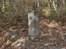
| Connecticut | Massachusetts | New York | See Brace Mountain or Mount Frissell. Marked with a stone inscribed with MASS-1898-NY and sometimes a "scratched-on" CONN.[10] |
| Connecticut | Massachusetts | Rhode Island | See Thompson, Connecticut. Marked with a stone inscribed with MASS-CONN-RI.[11] |
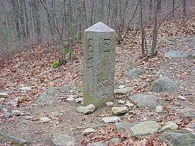
| Delaware | Maryland | Pennsylvania | See Delaware Wedge. Marked with a stone inscribed with M-M-P-P, as this was not the original intended tri-point.[12] |
| Georgia | North Carolina | Tennessee | Marked.[13] |
| Idaho | Montana | Wyoming | Located within Yellowstone National Park. Marked, although difficult to access.[14] |
| Idaho | Nevada | Oregon | Marked with a three-sided stone inscribed with N-I-O on the respective faces.[15] |
| Idaho | Nevada | Utah | Marked with a granite monument inscribed with the respective states' names.[16] |
| Idaho | Utah | Wyoming | Marked with a stone.[17] |
| Indiana | Michigan | Ohio | Brass marker with the shapes of the three states is located in a monument box beneath the surface of a rural road. Was set in 1999[18] and is referenced by a granite marker 20 feet to the east on the Michigan-Ohio line.[19] |
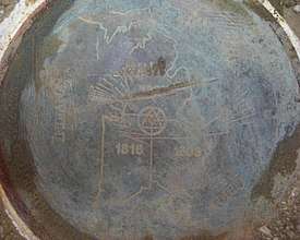
| Iowa | Minnesota | South Dakota | True point is marked with a disc in the center of a T-shaped road intersection.[20] A witness monument nearby in the South Dakota corner acknowledges the tri-point being set in 1859. |
| Kansas | Missouri | Oklahoma | Marked with a plaque on a seldom used dead-end road.[21] |
| Kentucky | Tennessee | Virginia | Tri-State Peak[22] Located within Cumberland Gap National Historical Park. Marked. |
| Kentucky | Virginia | West Virginia | Marked with a USCG marker on top of a two-foot high iron pipe at the river's high point.[23] |
| Maryland | Pennsylvania | West Virginia | Marked with a pyramid-like stone.[24] |
| Massachusetts | New Hampshire | Vermont | Marker is technically on dry land, but buried within river bed due to a dam's construction downstream.[25] |
| Massachusetts | New York | Vermont | Marked with a stone.[26] |
| Montana | North Dakota | South Dakota | Marked with a red granite stone.[27] |
| Montana | South Dakota | Wyoming | Marked with a stone within a fence.[28] |
| Nebraska | South Dakota | Wyoming | Marked with a stone within a fence.[29] |
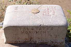
| New Jersey | New York | Pennsylvania | Marked by the Tri-States Monument by Port Jervis, New York, at the confluence of the Delaware and Neversink rivers.[30] |
| New Mexico | Oklahoma | Texas | Texhomex Marker |
| North Carolina | Tennessee | Virginia | Marked.[31] |
Water
Regions with no tripoint
The following tri-state areas are also notable, but have no tripoint:
See also
- Four Corners
- Four State Area
- Twin cities (geographical proximity), which includes tri-city
- Quad cities
References
- "Tri State Corners in the United States" (PDF). Jack Parsell.
- Wheatley, Thomas. "Camak Stone, border marker between Tennessee and Georgia, is missing". Creativeloafing.com. Retrieved 7 May 2017.
- Vardeman, Johnny. "Stolen stone returns home minus fanfare". Gainesville Times. Retrieved 7 May 2017.
- "Arizona–Nevada–Utah" (PDF). Bjbsoftware.com. Retrieved 27 August 2018.
- "Arkansas–Missouri–Oklahoma" (PDF). Bjbsoftware.com. Retrieved 27 August 2018.
- "Oregon–California–Nevada" (PDF). Bjbsoftware.com. Retrieved 27 August 2018.
- "Colorado–Nebraska–Kansas" (PDF). Bjbsoftware.com. Retrieved 27 August 2018.
- "Colorado–Nebraska–Wyoming" (PDF). Bjbsoftware.com. Retrieved 27 August 2018.
- "Colorado–Utah–Wyoming" (PDF). Bjbsoftware.com. Retrieved 27 August 2018.
- "Connecticut–Massachusetts–New York". Bjbsoftware.com. Retrieved 27 August 2018.
- "Connecticut–Massachusetts–Rhode Island". Bjbsoftware.com. Retrieved 27 August 2018.
- "Delaware–Maryland–Pennsylvania". Bjbsoftware.com. Archived from the original on March 19, 2002. Retrieved 27 August 2018.
- "Georgia–North Carolina–Tennessee" (PDF). Bjbsoftware.com. Retrieved 27 August 2018.
- "Idaho–Montana–Wyoming" (PDF). Bjbsoftware.com. Retrieved 27 August 2018.
- "Idaho–Nevada–Oregon" (PDF). Bjbsoftware.com. Retrieved 27 August 2018.
- "Idaho–Nevada–Utah" (PDF). Bjbsoftware.com. Retrieved 27 August 2018.
- "Idaho–Utah–Wyoming" (PDF). Bjbsoftware.com. Retrieved 27 August 2018.
- "Jack Parsell's description of the IN-MI-OH tripoint" (PDF). Bjbsoftware.com. Retrieved 27 August 2018.
- "Geocaching – The Official Global GPS Cache Hunt Site". Geocaching.com. Retrieved 27 August 2018.
- "Photo by Gregg A. Butler of the IA-MN-SD tripoint and its witness post" (JPG). Bjbsoftware.com. Retrieved 27 August 2018.
- "Kansas–Missouri–Oklahoma". Bjbsoftware.com. Retrieved 27 August 2018.
- "KY-TN-VA Tri-State Peak at Cumberland Gap National Historical Park". Nps.gov. Retrieved 1 April 2018.
- "Kentucky–Virginia–West Virginia" (PDF). Bjbsoftware.com. Retrieved 27 August 2018.
- "Maryland–Pennsylvania–West Virginia" (PDF). Bjbsoftware.com. Retrieved 27 August 2018.
- Eric Jones. New Hampshire Curiosities. Globe Pequot, 2006. p. 114-5
- "Massachusetts–New York–Vermont". Bjbsoftware.com. Retrieved 27 August 2018.
- "Montana–North Dakota–South Dakota" (PDF). Bjbsoftware.com. Retrieved 27 August 2018.
- "Montana–South Dakota–Wyoming" (PDF). Bjbsoftware.com. Retrieved 27 August 2018.
- "Nebraska–South Dakota–Wyoming" (PDF). Bjbsoftware.com. Retrieved 27 August 2018.
- "New York–Pennsylvania–New Jersey Tristate" (PDF). Bjbsoftware.com. Retrieved 14 January 2019.
- "North Carolina–Tennessee–Virginia" (PDF). Bjbsoftware.com. Retrieved 27 August 2018.
- "Iowa–Minnesota–Wisconsin". Bjbsoftware.com. Retrieved 27 August 2018.
External links
- Tripoint Guide
- Clark, Patterson; Lu, Denise (2015-09-17). "Cornering America's tri-points". The Washington Post. Retrieved 2016-10-05.