Trentham, Victoria
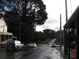
Trentham is a small town in the Shire of Hepburn and Shire of Moorabool local government area, Victoria, Australia. At the 2016 census, Trentham had a population of 1,180, with a median age of 55 years.[1] Located at an altitude of 700 metres (2,297 ft), the town is 87 kilometres (54 mi) north-west of Melbourne.
| Trentham Victoria | |||||||||||||||
|---|---|---|---|---|---|---|---|---|---|---|---|---|---|---|---|
 High Street | |||||||||||||||
 Trentham | |||||||||||||||
| Coordinates | 37°23′0″S 144°19′0″E | ||||||||||||||
| Population | 1,180 (2016 census)[1] | ||||||||||||||
| Postcode(s) | 3458 | ||||||||||||||
| Elevation | 700 m (2,297 ft) | ||||||||||||||
| Location |
| ||||||||||||||
| LGA(s) | |||||||||||||||
| State electorate(s) | Macedon | ||||||||||||||
| Federal Division(s) | Ballarat | ||||||||||||||
| |||||||||||||||
History
Although pastoral runs were taken up in the area as early as 1838, Trentham was first settled by gold prospectors in the 1850s, and later developed for its timber resources from the surrounding Wombat State Forest. The Post Office opened on 16 July 1862.[2]
A railway line arrived in 1880.[3] At its peak carried up to 21,000 tonnes of freight (mostly timber) annually. The station once had a timber tramway which transported timber to the Goods Platform. In the 1950s, however, the railway declined as better roads were built to connect the town with the major settlements of Victoria, and it was closed during the 1970s. The station is now the Trentham Agricultural and Railway Museum, with the restored station building, the mainly intact yard with some rolling stock, and a platform in good condition.
Potato growing (due to a fertile strip of red volcanic soil), grazing and tourism later became the mainstays of the town's economy.
Climate

The climate is cool and moist: the mean summer temperature (February) is 17.5 °C, nights fall to around 9.8 °C in December (summer); whilst winters are distinctly cold with the mean daytime temperature 7.8 °C (July) and mean night temperature 2.5 °C. The coldest temperature recorded was –6.0 °C; snowfall is not uncommon in winter; sleet and snow fall on an average of 13 days per annum.
Trentham has an average annual precipitation of 1110.9 mm; the highest single-day rainfall was 154.9 mm, and the highest monthly rainfall was 317.5 mm. The region has a distinct winter rainfall maximum. Rainfall occurs through the summer but tends to be more erratic and unreliable, often occurring in heavy downpours associated with thunderstorms.[4]
| Climate data for Trentham, VIC; 695 m AMSL; 37° 24′ 55.08″ S | |||||||||||||
|---|---|---|---|---|---|---|---|---|---|---|---|---|---|
| Month | Jan | Feb | Mar | Apr | May | Jun | Jul | Aug | Sep | Oct | Nov | Dec | Year |
| Record high °C (°F) | 39.4 (102.9) |
38.2 (100.8) |
36.1 (97.0) |
29.1 (84.4) |
23.9 (75.0) |
16.9 (62.4) |
18.3 (64.9) |
22.5 (72.5) |
25.0 (77.0) |
30.6 (87.1) |
37.0 (98.6) |
37.2 (99.0) |
39.4 (102.9) |
| Average high °C (°F) | 23.0 (73.4) |
23.2 (73.8) |
20.0 (68.0) |
15.4 (59.7) |
11.4 (52.5) |
8.6 (47.5) |
7.8 (46.0) |
9.4 (48.9) |
12.1 (53.8) |
15.8 (60.4) |
18.9 (66.0) |
21.7 (71.1) |
15.6 (60.1) |
| Daily mean °C (°F) | 17.1 (62.8) |
17.5 (63.5) |
15.0 (59.0) |
11.5 (52.7) |
8.5 (47.3) |
6.1 (43.0) |
5.2 (41.4) |
6.3 (43.3) |
8.3 (46.9) |
11.1 (52.0) |
13.5 (56.3) |
15.8 (60.4) |
11.3 (52.4) |
| Average low °C (°F) | 11.2 (52.2) |
11.8 (53.2) |
10.0 (50.0) |
7.5 (45.5) |
5.5 (41.9) |
3.5 (38.3) |
2.5 (36.5) |
3.1 (37.6) |
4.4 (39.9) |
6.4 (43.5) |
8.1 (46.6) |
9.8 (49.6) |
7.0 (44.6) |
| Record low °C (°F) | 0.0 (32.0) |
2.2 (36.0) |
0.5 (32.9) |
−2.0 (28.4) |
−2.8 (27.0) |
−6.0 (21.2) |
−6.0 (21.2) |
−4.2 (24.4) |
−5.9 (21.4) |
−2.5 (27.5) |
−3.0 (26.6) |
−1.0 (30.2) |
−6.0 (21.2) |
| Average precipitation mm (inches) | 56.7 (2.23) |
47.1 (1.85) |
56.9 (2.24) |
83.2 (3.28) |
116.1 (4.57) |
113.4 (4.46) |
143.9 (5.67) |
137.0 (5.39) |
108.3 (4.26) |
111.0 (4.37) |
72.4 (2.85) |
64.7 (2.55) |
1,110.9 (43.74) |
| Average precipitation days (≥ 0.2mm) | 7.4 | 7.0 | 8.8 | 10.4 | 13.7 | 15.0 | 16.4 | 16.1 | 14.4 | 13.3 | 10.4 | 9.2 | 142.1 |
| Source: [5] | |||||||||||||
Events and attractions
Near Trentham is Trentham Falls on the Coliban River–the highest single-drop waterfall in Victoria.[6] There are also several mineral springs near the town.
The annual Great Trentham Spudfest has been running since 2008, celebrating Trentham's potato-growing heritage.[7]
The town has an Australian Rules football team, the Trentham Saints, competing in the Maryborough Castlemaine District Football League.[8]
The Trentham Golf Club is on Falls Road.[9]
References
| Wikimedia Commons has media related to Trentham, Victoria. |
- Australian Bureau of Statistics (27 June 2017). "Trentham (State Suburb)". 2016 Census QuickStats. Retrieved 9 July 2017.

- Premier Postal History, Post Office List, retrieved 11 April 2008
- Osborne, Murrell (1978), Timber, Spuds and Spa, Australian Railway Historical Society, ISBN 0-85849-023-4
- "Climate statistics for Australian locations". www.bom.gov.au. Retrieved 11 April 2018.
- "Trentham climate data". Bureau of Meteorology. Retrieved 27 May 2019.
- Gray, Darren (19 September 2016). "Victorians flock to see and hear thunderous waterfalls after heavy rainfall". The Age. Retrieved 19 October 2016.
- "The Great Trentham Spudfest". The annual Great Trentham Spudfest. Retrieved 19 October 2016.
- "Trentham Saints". Retrieved 19 October 2016.
- Golf Select, Trentham, retrieved 11 May 2009