Trehafod
Trehafod is a village and community in the Rhondda Valley between Porth and Pontypridd in the county borough of Rhondda Cynon Taf, Wales. (The earlier name Hafod was altered to avoid confusion with Hafod near Swansea.) Administratively, it is split between the electoral division of Cymmer (Rhondda) to the west and Rhondda (Pontypridd) to the east. A former coalmining community, the village is now the site of the Rhondda Heritage Park, a tourist attraction commemorating the Rhondda valley coalmining industry.
| Trehafod | |
|---|---|
 | |
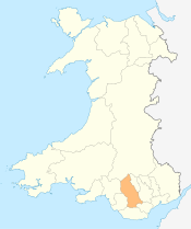
 Trehafod Location within Rhondda Cynon Taf | |
| Population | 498 (2011)[1] |
| OS grid reference | ST044909 |
| Principal area | |
| Ceremonial county | |
| Country | Wales |
| Sovereign state | United Kingdom |
| Post town | PONTYPRIDD |
| Postcode district | CF37 |
| Dialling code | 01443 |
| Police | South Wales |
| Fire | South Wales |
| Ambulance | Welsh |
| UK Parliament |
|
| Senedd Cymru – Welsh Parliament |
|
History

The 1847 tithe map of the area shows a number of farms on the area that was to become Trehafod, these were named, Hafod Uchaf, Hafod Ganol and Hafod Fawr. It was from these farms that Trehafod was to take its name. Hafod is a Welsh word that can mean "summer dwelling" or "upland farm".
Trehafod railway station lies on the Rhondda Line which follows the River Rhondda. The railway line and river border the village on either side.
Trehafod is now most famous for the Rhondda Heritage Park which was once the Lewis Merthyr colliery, at the peak time for coal mining production, one of the most productive collieries in the South Wales Coalfield.
Flooding
The village has frequently suffered flooding from the river, the most serious of which in 1960 claimed the life of an Afon street resident. (Afon is Welsh for 'river'.) Flooding also occurred in 1921, 1929 and 1979, after which the Rhondda River bank was reinforced. "The 1979 flood overtopped the banks of the River Rhondda just down river from Trehafod and floodwaters entered the low-lying areas of Colliery Street and Great Street causing flooding to many properties. A major river improvement scheme was completed in 1985 and no problems have occurred since then.[2]
External links
References
- "Community population 2011". Retrieved 15 November 2015.
- Taff Catchment Management Plan Consultation Report, April 1995. National Rivers Authority, Welsh Region
Places adjacent to Trehafod | ||||||||||
|---|---|---|---|---|---|---|---|---|---|---|
| ||||||||||
Villages and towns of the Rhondda Valley | ||
|---|---|---|
| Rhondda Fawr |  | |
| Rhondda Fach | ||