Transport in Coimbatore
Coimbatore has a well-developed transport infrastructure. The city and its suburbs is traversed using its road networks. Coimbatore is well connected by Road, Rail and Air with most cities and towns in India except through waterways. The city has fairly better transport infrastructure, though road infrastructures are not well maintained and developed according to the growing needs of transport, making traffic congestion a major problem in the city. A comprehensive transport development plan is made part of Coimbatore Masterplan as part to ease many of traffic problems.
Roads

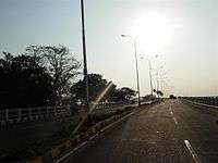
The city and metropolitan area are served by major arterial roads that run either in an east–west or north–south direction. Avinashi Road is one of the city's most important arterial roads. It traverses most of central and east Coimbatore (National Highway 47) connecting the metropolis of Bangalore, Chennai. The road runs in a west–east direction. Other arterials include Trichy Road (Central-Southeast), Mettupalayam Road (North-South), Sathy Road (South-North East), Palkkad Road(East-West), Pollachi Road(North-South) and Thadagam Road (east-west). Maruthamalai Road starts at the intersection of Lawley Road Junction and connects Vadavalli and extends up to Maruthamalai foothills. Other roads include 100 feet road, Bharatiyar Road, Dr.Nanjappa Road, Balasundarum Road, Crosscut Road in Gandhipuram Area, Diwhan Bahadhur Road(DB Road), TV Swamy Road, Brooke Bond Road in RS Puram Areas, Race Course Road etc. In January 2012, the Coimbatore Corporation announced that they would be laying around 10 roads by mixing plastic.[1]
National highways
Six major National Highways radiate outward from Coimbatore:
- NH 544(Avinashi road) towards Salem leading to Bangalore and Chennai.
- NH 544(Pallakad road) towards Trichur, Kochi and Trivandram
- NH 81(new NH code for Trichy Road) towards Karur, Tichy, Thanjavur and Nagapattinam.
- NH 181(Mettupalayam Road) towards Ooty and Gudalur leading to Karnataka and Kerala.
- NH 948(Sathy Road) towards Sathyamangalam, Chamrajnagar, Mysore, Bangalore.
- NH 83(Pollachi Road) towards Palani, Oddanchatram , Dindigul, Trichy, Tanjore, Nagapattinam.
Ring roads
There is a major bypass Built by L&T from Neelambur to Madukkarai on NH 47 which intersects trichy road at Chintamani Pudur near Irugur and Eachanari in Pollachi Road.[2]
The Coimbatore Corporation is undertaking the construction of six Rail-Over-Bridges in the city.[3]
The National Highways Authority of India has also invited feasibility studies to upgrade the National Highway connecting Pollachi and Bannari passing through the city.[4]
Public transport
- For the proposed bus rapid transit systems, see Coimbatore BRTS
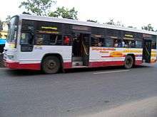
Most of Coimbatore's intra-city transport requirements are met by an extensive public transport. The bus service, which is run by the government-owned TNSTC Coimbatore covers the city and its suburbs. A large number of intra-city private buses operate within the city. Bus services are generally considered efficient, but buses on some routes can get very crowded at times. The bus service, which plies about 1257 buses on 322 routes. The city is also served by auto rickshaws. The growth of call taxis is also on the rise.
In addition to the bus service, private metered call taxis and fixed-rate tourist taxis are available at all entry points to the city such as the airport, bus terminals and railway stations. Vans which are run like bus services and popularly called "Maxi Cabs" also ply on many routes in the city. The outlying suburban areas of the city are also served by private mini bus company services as well as government bus transport corporations of neighbouring districts.
The city has a very high vehicle-to-population ratio. Town buses started operations in 1921. Town bus services serve most parts of the city, as well as other towns and villages in the district. Buses also connect the district with all major towns in Tamil Nadu, Kerala, Karnataka, Pondicherry and Andhra Pradesh. The number of inter-city routes operated by Coimbatore division is 119 with a fleet of more than 500 buses. Despite a sharp increase in the number of four-wheelers in the city, ]s and motorscooters are still very prevalent, all of which are preferred to cars due to their affordability, fuel efficiency, maneuverability, and ease of parking.
List of Moffusil and Town Bus Stands
- Gandhipuram Town Bus stand
- Gandhipuram Moffusil Bus stand
- Gandhipuram Thiruvalluvar Bus stand (For SETC(TNSTC) and KSRTC Buses)
- Gandhipuram Omni Bus stand (Near G.P. Signal)
- Singanallur Moffusil and Town Bus stand
- New Bus stand (Near Saibaba Temple)
- Ukkadam Moffusil and Town Bus stand
- Vellalore Integrated Bus stand (Upcoming)
List of TNSTC Coimbatore depots in Coimbatore City
- Head-Office Branch(City & Moffusil)
- Upppilipalayam(Moffusil only)
- Sungam-1(City & Moffusil)
- Sungam-2(City only)
- Ukkadam-1(City & Moffusil)
- Ukkadam-2(City & Moffusil)
- Ondipudhur-1(City only)
- Ondipudhur-2(Moffusil only)
- Marudhamalai(City only)
- Ondipudhur-3(City & Moffusil)
also Annur,Pollachi-3,Mettupalayam-1,Karumathampatti & Palladam depots operate City Services for Coimbatore
Air
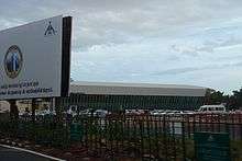
Coimbatore International Airport (IATA: CJB, ICAO: VOCB) is a major airport mostly serving Coimbatore and its suburbs in the state of Tamil Nadu, India. The Coimbatore International Airport is the second busiest airport in Tamil Nadu after Chennai International Airport, in terms of passenger traffic, cargo traffic as well as aircraft movement. The Coimbatore International Airport serves as the city's airport for both domestic and international flights. The airport consists of separate International terminal and the Domestic terminal, and handles domestic as well as international flights. The city is connected to major hubs in South Asia, South East Asia and Middle East through over eight international carriers. The Airport lies around 12 km from the city centre and is accessible by road and rail transport services.
This airport is undergoing modernisation and expansion of the runway, including the alteration of an additional terminal. Furthermore, a new greenfield airport will be constructed in Nellambur and nearby areas to serve the city's better air connectivity, after the expansion of the runway which will be second longest runway in South India about 12,500 ft. The present terminal buildings in Peelamedu will be used for cargo purpose.
Other airports in the metropolitan area include the Indian Air Force base at Sulur. Sulur Air Force Station was established in 1940 by the British Royal Navy.
Railways
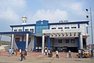
Coimbatore Junction, also known as Kovai Junction, is the primary railway station serving the city of Coimbatore. It has six platforms. It is a Major Railway junction in South India and the Second busiest and revenue yielding railway station in Tamil Nadu after Chennai. Many trains from Kerala to other parts of the country pass through Coimbatore Junction apart from 18 pairs of terminating express trains. It is one of the top booking stations in India according to Indian Railway.[5][6][7]
Metro
Coimbatore Metro is also known as Kovai Metro is the proposed metro rail system for the city of Coimbatore, Tamil Nadu. The Government of Tamil Nadu proposed a metro rail system for Coimbatore. However, in 2011, the plan was shelved in favour of a monorail system. In January 2017, a Coimbatore District Administration official told The Hindu that there was no mass rapid system presently under consideration for Coimbatore.[1] The government again announced a plan to construct metro rail in 2017. Railway Minister Suresh Prabu has announced metro rail facility for Coimbatore. He also mentioned that central government is ready to implement metro rail in Coimbatore. State government has also approved for metro rail. The works will begin by next fiscal year 2017–18. Government announced that DPR for Coimbatore metro rail will be prepared by CMRL and it will be funded by German-based company.Feasibility report submitted by Systra to CMRL and sent for government approval. DPR To be prepared after Approval of Feasibility study..
Suburban railway
Coimbatore railways has unique infrastructure to host circular rail system as it has similar bus service inside the city limits. Future potential, utility and savings are huge once such circular railway linking Coimbatore, Coimbatore north, Peelamedu, Irugur and Podanur before touching Coimbatore junction back. Another unique infrastructure that can be utilized better is the 4 radiating rail routes from Coimbatore junction and next town at 40 km each from there. It is a golden opportunity for EMUs crisscrossing with best convenience and efficiency. The other junctions are located at Coimbatore North Junction (2.6 km away from CBE on the northern side), Podanur Junction (5.8 km away from CBE on the southern side)and Irugur(16 km from CBE on eastern side)[8]
BRTS
The Coimbatore BRTS is a proposed bus rapid transit system for the city of Coimbatore under the JNNURM scheme. Project stretch of about 18.6 km starting at Avinashi Road and ending at Mettupalayam Road running through Dr.Rajendra Prasath Road. After Avinashi road, the project road turns left from Stanes School and passes along Dr.Nanjappa road and joins at Dr. Rajendra Prasad Road (100 Ft. Road). Avinashi road, Dr. Rajendra Prasad Road and Mettupalyam road are provided with the exclusive lane for buses termed BRTS lane and the connecting links are allowed to flow with the mixed traffic.
A Dedicated Two Lane carriageway of width 7.0m is provided for BRTS corridor. A Dual Lane for Mixed Traffic of Width 7.0m is provided on either side of the BRTS corridor. The Mixed traffic lane is separated from the BRTS lane by providing 250mm wide CC block on both sides. 2.0m wide Cycle Track over and 2.0m wide Footpath over built-up drain is proposed on either side of Mixed Traffic Lane. The Cycle Track is separated from Mixed Traffic Lane by providing 250mm CC Buttons. Out of Total 17.6 km BRTS is passing at grade for a length of 6.64 km (dedicated) and 6.87 km is passing through elevated section. It is proposed to have 14 at grade bus stops and 3 elevated bus stops.
See also
- Coimbatore BRTS
- Coimbatore Bypass
- Coimbatore International Airport
- Coimbatore Junction
- Coimbatore North Junction
- Transport in Chennai
- Transport in India
- Coimbatore Metro
References
- Madhavan, Karthik (10 January 2012). "Coimbatore Corporation to go in for plastic roads". The Hindu. p. 1. Retrieved 16 January 2012.
- "Coimbatore Bypass Road". New Delhi: Department of Economic Affairs, Ministry of Finance, Government of India. Archived from the original on 26 January 2016. Retrieved 16 January 2012.
- V. S., Palaniappan (8 January 2012). "Bridge works across six level crossings speed up". Coimbatore: The Hindu. Retrieved 16 January 2012.
- "NHAI's DPR on widening NH 209 by Mar". Coimbatore: Asapp Media. 6 January 2012. Retrieved 16 January 2012.
- "Indian Railways Passenger Reservation Enquiry". indianrail.gov.in. Archived from the original on 10 May 2014. Retrieved 23 November 2012.
- "Station Names with Station Codes". Retrieved 23 November 2012.
- "Computerized Reservation Offices in Tamilnadu". Retrieved 23 November 2012.
- "Route KM-Statewise" (PDF). Retrieved 23 November 2012.