Toyono, Osaka
Toyono (豊能町, Toyono-chō) is one of the two towns in Toyono District. The town is located in the second northernmost area in Osaka Prefecture, Japan. The town is surrounded by two municipal borders to Kyoto Prefecture and Kawanishi city (Hyogo Prefecture). The town covers the hilly and forest area in northern Osaka Prefecture. The West Block is at 200 to 300 meters high altitude, and the East and Southeast Blocks are at 400 to 600 meters high.
Toyono 豊能町 | |
|---|---|
Town | |
 Toyono town office | |
 Flag | |
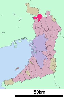 Location of Toyono in Osaka Prefecture | |
 Toyono Location in Japan | |
| Coordinates: 34°55′N 135°30′E | |
| Country | Japan |
| Region | Kansai Kinki |
| Prefecture | Osaka Prefecture |
| District | Toyono |
| Government | |
| • Mayor | Ryuichi Tanaka |
| Area | |
| • Total | 34.37 km2 (13.27 sq mi) |
| Population (October 1, 2016) | |
| • Total | 19,519 |
| • Density | 570/km2 (1,500/sq mi) |
| Time zone | UTC+9 (JST) |
| City hall address | 414-1 Yono, Toyono-chō, Toyono-gun, Osaka-fu 563-0292 |
| Website | www |
As of October 2016, the town has an estimated population of 19,519 and a density of 570 persons per km². The total area is 34.37 km².
The West Block has a few convenient access to the nearby city area within a 10-minute car drive. The Super highway provides an exit called "Minoh Todoromi" and the electrical railways provide 3 stations in the West Block. The railway runs to the northwest and to the south. It takes less than 1 hour to Osaka Umeda Station.
Transportation
Railways
- Nose Railway
- Myoken Line
- - Kofudai Station (Osaka) - Tokiwadai Station (Osaka) - Myōkenguchi Station
- Myoken Line
Buses
- Hankyu Bus
Highway
- National Routes
Blocks (City Block's Postal Zip Code)
West Block
- Yoshikawa 563-0101
- Tokiwadai 563-0102
- Higashi-Tokiwadai 563-0103
- Kofudai 563-0104
- Shinkofudai 563-0105
- Honotani 563-0100
East Block
- Yono 563-0219
- Nomaguchi 563-0218
- Maki 563-0211
- Kirihata 563-0213
- Terada 563-0212
- Kawashiri 563-0217
- Kishiro 563-0215
- Kibogaoka 563-0214
Southeast Block
- Takayama 563-0216
External links

- Toyono official website (in Japanese)
- Nose Railway, Life along the railways
| Authority control |
|
|---|
Osaka (capital) | ||
| Wards of Osaka | ||
| Wards of Sakai | ||
| Core cities |
| |
| Cities to become core cities | ||
| Special cities | ||
| Cities | ||
| Districts | ||