Towner, North Dakota
Towner is a city in McHenry County, North Dakota, United States. It is the county seat of McHenry County.[5] The population was 533 at the 2010 census.[6] It is part of the Minot Micropolitan Statistical Area. Towner was founded in 1886.
Towner, North Dakota | |
|---|---|
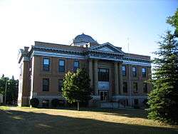 McHenry County Courthouse in Towner | |
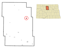 Location of Towner, North Dakota | |
| Coordinates: 48°20′43″N 100°24′22″W | |
| Country | United States |
| State | North Dakota |
| County | McHenry |
| Government | |
| • Type | City Commission |
| Area | |
| • Total | 0.81 sq mi (2.10 km2) |
| • Land | 0.81 sq mi (2.10 km2) |
| • Water | 0 sq mi (0 km2) |
| Elevation | 1,476 ft (450 m) |
| Population | |
| • Total | 533 |
| • Estimate (2018)[3] | 535 |
| • Density | 660/sq mi (250/km2) |
| Time zone | UTC-6 (Central (CST)) |
| • Summer (DST) | UTC-5 (CDT) |
| ZIP code | 58788 |
| Area code(s) | 701 |
| FIPS code | 38-79420 |
| GNIS feature ID | 1032511[4] |
| Website | townernd.com |
Despite their similar names, the city of Towner is not in Towner County, North Dakota.
History

Towner sprang up in 1886 with the arrival of the Great Northern Railway into the area. It was named for rancher O. M. Towner.[7]
Geography
Towner is located at 48°20′43″N 100°24′22″W (48.345208, -100.406036).[8]
According to the United States Census Bureau, the city has a total area of 0.81 square miles (2.10 km2), all of it land.[1]
Demographics
| Historical population | |||
|---|---|---|---|
| Census | Pop. | %± | |
| 1890 | 211 | — | |
| 1900 | 331 | 56.9% | |
| 1910 | 691 | 108.8% | |
| 1920 | 610 | −11.7% | |
| 1930 | 622 | 2.0% | |
| 1940 | 918 | 47.6% | |
| 1950 | 955 | 4.0% | |
| 1960 | 948 | −0.7% | |
| 1970 | 870 | −8.2% | |
| 1980 | 867 | −0.3% | |
| 1990 | 669 | −22.8% | |
| 2000 | 574 | −14.2% | |
| 2010 | 533 | −7.1% | |
| Est. 2018 | 535 | [3] | 0.4% |
| U.S. Decennial Census[9] 2018 Estimate[10] | |||
2010 census
As of the census[2] of 2010, there were 533 people, 267 households, and 149 families residing in the city. The population density was 658.0 inhabitants per square mile (254.1/km2). There were 337 housing units at an average density of 416.0 per square mile (160.6/km2). The racial makeup of the city was 96.6% White, 1.9% Native American, 0.6% from other races, and 0.9% from two or more races. Hispanic or Latino of any race were 5.3% of the population.
There were 267 households of which 22.1% had children under the age of 18 living with them, 43.4% were married couples living together, 9.0% had a female householder with no husband present, 3.4% had a male householder with no wife present, and 44.2% were non-families. 41.6% of all households were made up of individuals and 24.4% had someone living alone who was 65 years of age or older. The average household size was 2.00 and the average family size was 2.69.
The median age in the city was 49.9 years. 20.5% of residents were under the age of 18; 5.3% were between the ages of 18 and 24; 18.1% were from 25 to 44; 29.1% were from 45 to 64; and 27% were 65 years of age or older. The gender makeup of the city was 48.6% male and 51.4% female.
2000 census
As of the census of 2000, there were 574 people, 295 households, and 158 families residing in the city. The population density was 694.0 people per square mile (267.0/km²). There were 335 housing units at an average density of 405.0 per square mile (155.8/km²). The racial makeup of the city was 97.91% White, 0.35% African American, 0.35% Native American, and 1.39% from two or more races. Hispanic or Latino of any race were 0.87% of the population.
There were 295 households out of which 18.3% had children under the age of 18 living with them, 44.7% were married couples living together, 6.4% had a female householder with no husband present, and 46.4% were non-families. 42.0% of all households were made up of individuals and 23.1% had someone living alone who was 65 years of age or older. The average household size was 1.95 and the average family size was 2.66.
In the city, the population was spread out with 17.1% under the age of 18, 6.1% from 18 to 24, 20.7% from 25 to 44, 27.2% from 45 to 64, and 28.9% who were 65 years of age or older. The median age was 50 years. For every 100 females, there were 86.4 males. For every 100 females age 18 and over, there were 82.4 males.
The median income for a household in the city was $25,536, and the median income for a family was $44,375. Males had a median income of $29,500 versus $17,375 for females. The per capita income for the city was $19,598. About 3.2% of families and 10.2% of the population were below the poverty line, including 4.4% of those under age 18 and 16.5% of those age 65 or over.
Climate
This climatic region is typified by large seasonal temperature differences, with warm to hot (and often humid) summers and cold (sometimes severely cold) winters. According to the Köppen Climate Classification system, Towner has a humid continental climate, abbreviated "Dfb" on climate maps.[11]
| Climate data for Towner | |||||||||||||
|---|---|---|---|---|---|---|---|---|---|---|---|---|---|
| Month | Jan | Feb | Mar | Apr | May | Jun | Jul | Aug | Sep | Oct | Nov | Dec | Year |
| Record high °C (°F) | 10.6 (51.1) |
17.2 (63.0) |
26.1 (79.0) |
35.0 (95.0) |
41.1 (106.0) |
41.1 (106.0) |
43.9 (111.0) |
40.6 (105.1) |
39.4 (102.9) |
35.0 (95.0) |
24.4 (75.9) |
19.4 (66.9) |
43.9 (111.0) |
| Average high °C (°F) | −8.9 (16.0) |
−6.2 (20.8) |
0.9 (33.6) |
12.2 (54.0) |
19.9 (67.8) |
24.4 (75.9) |
28.3 (82.9) |
27.7 (81.9) |
21.6 (70.9) |
14.1 (57.4) |
2.2 (36.0) |
−5.7 (21.7) |
10.9 (51.6) |
| Daily mean °C (°F) | −15.1 (4.8) |
−12.4 (9.7) |
−5.2 (22.6) |
5.2 (41.4) |
12.1 (53.8) |
17.2 (63.0) |
20.4 (68.7) |
19.2 (66.6) |
13.3 (55.9) |
6.4 (43.5) |
−3.6 (25.5) |
−11.6 (11.1) |
3.8 (38.8) |
| Average low °C (°F) | −21.3 (−6.3) |
−18.7 (−1.7) |
−11.3 (11.7) |
−1.9 (28.6) |
4.3 (39.7) |
9.8 (49.6) |
12.4 (54.3) |
10.7 (51.3) |
5.1 (41.2) |
−1.2 (29.8) |
−9.4 (15.1) |
−17.3 (0.9) |
−3.2 (26.2) |
| Record low °C (°F) | −45.0 (−49.0) |
−44.4 (−47.9) |
−41.1 (−42.0) |
−28.9 (−20.0) |
−11.1 (12.0) |
−3.9 (25.0) |
0.0 (32.0) |
−5.6 (21.9) |
−11.1 (12.0) |
−26.1 (−15.0) |
−36.7 (−34.1) |
−42.2 (−44.0) |
−45.0 (−49.0) |
| Average precipitation mm (inches) | 14 (0.6) |
12 (0.5) |
18 (0.7) |
30 (1.2) |
54 (2.1) |
78 (3.1) |
62 (2.4) |
54 (2.1) |
43 (1.7) |
26 (1.0) |
16 (0.6) |
13 (0.5) |
419 (16.5) |
| Source: [12] | |||||||||||||
References
- "US Gazetteer files 2010". United States Census Bureau. Archived from the original on 2012-07-02. Retrieved 2012-06-14.
- "U.S. Census website". United States Census Bureau. Retrieved 2012-06-14.
- "Population and Housing Unit Estimates". Retrieved June 16, 2019.
- "US Board on Geographic Names". United States Geological Survey. October 25, 2007. Retrieved January 31, 2008.
- "Find a County". National Association of Counties. Retrieved 2011-06-07.
- "2010 Census Redistricting Data (Public Law 94-171) Summary File". American FactFinder. United States Census Bureau. Retrieved 2 May 2011.
- Hellmann, Paul T. (May 13, 2013). Historical Gazetteer of the United States. Routledge. p. 842. Retrieved 30 November 2013.
- "US Gazetteer files: 2010, 2000, and 1990". United States Census Bureau. 2011-02-12. Retrieved 2011-04-23.
- United States Census Bureau. "Census of Population and Housing". Retrieved October 30, 2013.
- "Population Estimates". United States Census Bureau. Retrieved June 16, 2019.
- Climate Summary for Towner, North Dakota
- "Towner, North Dakota Temperature Averages". Weatherbase. Retrieved 4 July 2015.
External links
- TGU-Towner School http://www.towner.k12.nd.us/
- Centennial celebration, June 20-21, 1987, Zion Lutheran Church, Towner, North Dakota, 1887-1987 from the Digital Horizons website
- Towner, North Dakota: community fact survey (1965) from the Digital Horizons website
Municipalities and communities of McHenry County, North Dakota, United States | ||
|---|---|---|
| Cities | 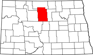 Map of North Dakota highlighting McHenry County | |
| Townships |
| |
| Unorganized territory |
| |
| Unincorporated communities | ||
| Indian reservation | ||
| Footnotes | ‡This populated place also has portions in an adjacent county or counties | |