Tourrettes, Var
Tourrettes is a commune in the Var department in the Provence-Alpes-Côte d'Azur region in southeastern France.
Tourrettes | |
|---|---|
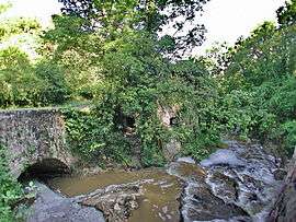 Chautard river with an ancient watermill, in Tourrettes | |
.svg.png) Coat of arms | |
Location of Tourrettes 
| |
 Tourrettes  Tourrettes | |
| Coordinates: 43°37′27″N 6°42′11″E | |
| Country | France |
| Region | Provence-Alpes-Côte d'Azur |
| Department | Var |
| Arrondissement | Draguignan |
| Canton | Roquebrune-sur-Argens |
| Intercommunality | Pays de Fayence |
| Government | |
| • Mayor (2008–) | Camille Bouge |
| Area 1 | 33.99 km2 (13.12 sq mi) |
| Population (2017-01-01)[1] | 2,884 |
| • Density | 85/km2 (220/sq mi) |
| Time zone | UTC+01:00 (CET) |
| • Summer (DST) | UTC+02:00 (CEST) |
| INSEE/Postal code | 83138 /83440 |
| Elevation | 155–592 m (509–1,942 ft) (avg. 334 m or 1,096 ft) |
| 1 French Land Register data, which excludes lakes, ponds, glaciers > 1 km2 (0.386 sq mi or 247 acres) and river estuaries. | |
Tourrettes is one of a series of "perched villages" overlooking the plain between the southern Alps and the Esterel massif, which borders the sea between Cannes and Saint-Raphaël. Tourrettes is a charming old Provençal village popular with tourists. The village is located on the road to Mons, which later on joins the Route Napoléon (linking Nice to Grenoble through the Alps).
In the recent years a high-standing golf resort has settled in Tourrettes : the Domaine de Terre Blanche attracting a foreign clientele.
The aerodrome of Fayence-Tourrettes was one of the most active in Europe.
See also
External links
| Wikimedia Commons has media related to Tourrettes. |
- INSEE
- Homepage Commune de Tourrettes
- More info
- Dolmen de Tourrettes
- Gliding at Fayence-Tourrettes Airfield
- "Populations légales 2017". INSEE. Retrieved 6 January 2020.
| Authority control |
|
|---|
This article is issued from Wikipedia. The text is licensed under Creative Commons - Attribution - Sharealike. Additional terms may apply for the media files.