Tornado outbreak sequence of April 30–May 2, 1967
The tornado outbreak sequence of April 30–May 2, 1967, was a destructive severe weather episode that affected portions of the Midwestern and Southern United States from April 30–May 2, 1967. It consisted of two consecutive tornado outbreaks that generated at least thirty-eight tornadoes, causing thirteen fatalities and ninety injuries. All of the deaths occurred on April 30, which is known as the 1967 Iowa–Minnesota tornado outbreak, or Black Sunday, to residents of Iowa and southern Minnesota. That day spawned a total of twenty-one tornadoes, devastating the towns of Albert Lea and Waseca, Minnesota.[3][4][nb 2]
Part of the tornado outbreaks of 1967 | |
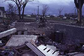 A home leveled to its foundation in Waseca, Minnesota | |
| Type | Tornado outbreak sequence |
|---|---|
| Duration | April 30–May 2, 1967 |
| Tornadoes confirmed | 38 |
| Max. rating1 | F4 tornado |
| Duration of tornado outbreak2 | 2 days, 2 hours, and 55 minutes |
| Highest gust | 70 kn (81 mph; 130 km/h) in Louisiana on May 1[1] |
| Largest hail | 2 3⁄4 in (7.0 cm) in diameter in Pittsburgh County, Oklahoma, on April 30[2] |
| Damage | ≥ $11.03 million (1967 USD)[nb 1] |
| Casualties | 13 fatalities, ≥90 injuries |
| Areas affected | Midwestern and Southern United States (particularly Iowa and Minnesota) |
| 1Most severe tornado damage; see Fujita scale 2Time from first tornado to last tornado | |
Background
Beginning on April 30, 1967, a potent mid-latitude cyclone generated severe weather, including blizzards and severe thunderstorms, across a broad region extending from the northernmost High Plains and Rocky Mountains to the Mississippi and Ohio River valleys. These conditions occurred within a seventy-two-hour-long span.[6] By 1:00 p.m. CDT (12:00 p.m. CST; 18:00 UTC) on April 30, a low-pressure area of at most 984 millibars (29.06 inHg) was centered near Pierre, South Dakota, with a stationary front superimposed from north of Sioux Falls to near LaCrosse, Wisconsin. Nearby, a warm front also attended from south of Sioux Falls to near Des Moines, Iowa, and St. Louis, Missouri.[7] As the warm sector advanced into northernmost Iowa and southern Minnesota, surface air temperatures rose into the 60s and low 70s °F, while dew points reached the 60s °F. Winds at the surface ranged from 15 to 25 miles per hour (24 to 40 km/h) out of the east-southeast.[7] By 7:00 p.m. CDT (6:00 p.m. CST; 00:00 UTC), the warm front migrated to near the Minnesota-Iowa border, while the mid-level trough associated with the surface cyclone acquired a negative tilt. At the same time, a strong jet stream brought deep-layer wind shear over portions of northern Iowa and southern Minnesota—indicating favorable conditions for tornadogenesis.[8]
Daily statistics
| FU | F0 | F1 | F2 | F3 | F4 | F5 | Total |
|---|---|---|---|---|---|---|---|
| 0 | 1 | 8 | 21 | 4 | 4 | 0 | 38 |
| "FU" denotes unclassified but confirmed tornadoes. | |||||||
| Date | Total | Fujita scale rating | Deaths | Injuries | Damage | Ref. | ||||||
|---|---|---|---|---|---|---|---|---|---|---|---|---|
| FU | F0 | F1 | F2 | F3 | F4 | F5 | ||||||
| April 30 | 21 | 0 | 0 | 4 | 10 | 3 | 4 | 0 | 13 | 81 | ≥$11,000,000 | [9][10][11][12] |
| May 1 | 14 | 0 | 0 | 4 | 8 | 1 | 0 | 0 | 0 | 9 | ≥$25,000 | [9][10][13] |
| May 2 | 3 | 0 | 1 | 0 | 3 | 0 | 0 | 0 | 0 | 0 | Unknown | [9][10][13] |
| Total | 38 | 0 | 1 | 8 | 21 | 4 | 4 | 0 | 13 | 90 | ≥$11,025,000 | [9][10][11][13] |
| State | Total | County | County total |
|---|---|---|---|
| Minnesota | 13 | Freeborn | 7 |
| Waseca | 6 | ||
| Totals | 13 | ||
| All deaths were tornado-related | |||
List of tornadoes
| F# | Location | County / Parish | State | Start coord. |
Date | Time (UTC) | Path length | Max. width | Summary |
|---|---|---|---|---|---|---|---|---|---|
| F1 | NW of De Smet | Kingsbury | SD | 44.40°N 97.57°W | April 30 | 21:15–? | 0.1 miles (0.16 km) | N/A | A brief tornado struck unpopulated countryside, resulting in no material damage.[15] |
| F2 | NW of Vincent to ENE of Thor | Webster | IA | 42.60°N 94.03°W | April 30 | 21:50–? | 6.8 miles (10.9 km) | N/A | Tornado researcher Thomas P. Grazulis did not list this tornado as an F2 or stronger.[10] |
| F2 | ESE of Gruver to SE of Huntington | Emmet | IA | 43.38°N 94.68°W | April 30 | 22:00–? | 8.2 miles (13.2 km) | N/A | This tornado struck six barns, one of which was destroyed.[16] Damage was also reported in Dolliver.[17] |
| F2 | Emmetsburg to WNW of Ringsted | Palo Alto, Emmet | IA | 43.12°N 94.67°W | April 30 | 22:10–? | 14 miles (23 km) | N/A | This tornado struck the western portion of the community of Halfa, tearing the roofs off several homes. While passing east of Gridley, it also destroyed barns.[16] |
| F2 | WSW of Crystal Lake | Hancock, Winnebago | IA | 43.22°N 93.80°W | April 30 | 22:30–? | 4.3 miles (6.9 km) | N/A | This tornado struck eight farmsteads, three of which were nearly destroyed, except for the farmhouses.[16] |
| F2 | NNE of Gruver | Emmet | IA | 43.42°N 94.68°W | April 30 | 22:33–? | 1 mile (1.6 km) | N/A | Grazulis did not list this tornado as an F2 or stronger.[10] |
| F3 | Clear Lake area | Cerro Gordo | IA | 43.10°N 93.42°W | April 30 | 23:05–? | 7.7 miles (12.4 km) | N/A | This tornado destroyed barns, agricultural machinery, and one home.[16] Observers reported three distinct funnel clouds.[17] Grazulis listed the tornado as an F2.[16] |
| F2 | Fort Madison area | Lee | IA | 40.63°N 91.32°W | April 30 | 23:20–? | 2.3 miles (3.7 km) | N/A | Grazulis did not list this tornado as an F2 or stronger.[10] |
| F4 | ENE of Manly to SSE of Otranto | Worth | IA | 43.30°N 93.17°W | April 30 | 23:28–? | 13.3 miles (21.4 km) | N/A | This violent tornado caused extensive damage to approximately ten farms.[16] |
| F3 | SSE of Kensett to N of London, MN | Worth (IA), Freeborn (MN) | IA, MN | 43.33°N 93.20°W | April 30 | 23:30–? | 17.2 miles (27.7 km) | N/A | This tornado caused extensive damage to six farmsteads and destroyed a few homes.[18] |
| F2 | W of Lemond to NE of Waseca | Waseca | MN | 43.98°N 93.42°W | April 30 | 00:00–? | 9.2 miles (14.8 km) | N/A | This tornado destroyed barns as it passed near Lemond and west of Meriden. The total path length may have been 30 miles (48 km).[16] |
| F3 | Alden to ESE of Matawan | Freeborn, Waseca | MN | 43.67°N 93.58°W | April 30 | 00:05–? | 14 miles (23 km) | N/A | Two deaths – Near the start of its path, this tornado neared the threshold of F4-level intensity, based on structural damage to farms. Additionally, the tornado destroyed barns.[16] Twenty-three people sustained injuries.[19] |
| F1 | WSW of Union | Steele | MN | 43.87°N 93.20°W | April 30 | 00:05–? | 0.2 miles (0.32 km) | N/A | N/A |
| F4 | ENE of Northwood to ENE of Myrtle, MN | Worth (IA), Freeborn (MN) | IA, MN | 43.45°N 93.17°W | April 30 | 00:20–? | 7.6 miles (12.2 km) | N/A | This powerful tornado destroyed ten farms in Minnesota, three of which sustained borderline-F5-level damage.[16] One injury was reported.[20] |
| F4 | NNW of Twin Lakes to Albert Lea to Owatonna | Freeborn, Steele | MN | 43.57°N 93.43°W | April 30 | 00:23–? | 38.7 miles (62.3 km) | N/A | 5 deaths – This destructive, long-tracked tornado caused $2 million in damages in Albert Lea alone.[18] The tornado ravaged the western portion of the town; there, it significantly damaged fifty-five homes, and "completely leveled" ten others.[21] In all, the tornado destroyed twenty-six homes and severely damaged an additional sixty-four in Albert Lea. Along its entire path, the tornado flattened farms at six different locations.[18] The tornado also destroyed many structures on farms near Owatonna.[21] The tornado injured a total of thirty-five people.[22] |
| F4 | W of Hartland to NNE of Waseca | Freeborn, Waseca | MN | 43.80°N 93.52°W | April 30 | 00:52–? | 20.1 miles (32.3 km) | N/A | 6 deaths – This tornado was the last violent event of the entire outbreak sequence. It paralleled Minnesota State Highway 13, known then as Highway 67, and damaged farms on each side of the highway. In Waseca, the tornado leveled six homes, destroyed sixteen, and extensively damaged twenty-five.[18] The tornado injured twenty-two people.[23] |
| F1 | NW of Littleton | Buchanan | IA | 42.55°N 92.05°W | April 30 | 01:00–? | 0.1 miles (0.16 km) | N/A | N/A |
| F1 | NW of Montezuma | Poweshiek | IA | 41.60°N 92.55°W | April 30 | 01:00–? | 0.1 miles (0.16 km) | N/A | N/A |
| F2 | SE of Austin to E of Nicolville | Mower | MN | 43.63°N 92.93°W | April 30 | 01:15–? | 3.8 miles (6.1 km) | N/A | This short-lived tornado destroyed a few barns and unroofed a home on a farmstead.[18] |
| F2 | S of Marion to N of Eyota | Olmsted | MN | 43.93°N 92.35°W | April 30 | 02:10–02:15 | 6.8 miles (10.9 km) | N/A | This tornado destroyed a barn and a trailer.[18] |
| F2 | SSE of Epworth | Dubuque | IA | 42.40°N 90.90°W | April 30 | 03:00–? | 2 miles (3.2 km) | N/A | Grazulis did not list this tornado as an F2 or stronger.[10] |
| F2 | E of North Zulch | Madison | TX | 30.92°N 96.08°W | May 1 | 12:00–? | 0.6 miles (0.97 km) | N/A | A brief tornado destroyed a barn and a livestock pen. Fencing was wrenched from the ground as well.[24] Grazulis did not list this tornado as an F2 or stronger.[10] |
| F1 | NNW of Lambert | Hot Spring | AR | 34.35°N 93.23°W | May 1 | 13:20–? | 0.1 miles (0.16 km) | N/A | A brief tornado felled many trees and damaged one home.[25] |
| F2 | WSW of Ebenezer | Camp | TX | 32.95°N 94.92°W | May 1 | 13:30–? | 1 mile (1.6 km) | N/A | A brief tornado destroyed a pair of chicken coops and damaged a number of large livestock feeders. Trees were downed as well.[24] Grazulis did not list this tornado as an F2 or stronger.[10] |
| F1 | Mount Pleasant area | Wood | TX | 33.17°N 94.97°W | May 1 | 16:00–? | 0.1 miles (0.16 km) | N/A | A brief tornado damaged several buildings and a farmhouse on up to six farmsteads. Trees were uprooted as well.[24] |
| F2 | NNE of Corsicana | Navarro | TX | 32.17°N 96.45°W | May 1 | 16:00–? | 2 miles (3.2 km) | N/A | A brief tornado, coincident and possibly in conjunction with downbursts, flipped a mobile home and damaged or destroyed a few houses and several barns. A large pecan was prostrated as well.[24] Grazulis did not list this tornado as an F2 or stronger.[10] |
| F0 | SSE of Avinger | Cass | TX | 32.88°N 94.55°W | May 1 | 17:00–? | 0.5 miles (0.80 km) | N/A | A brief tornado sheared and uprooted trees beside a church.[24] |
| F1 | W of Negreet | Sabine | LA | 31.47°N 93.60°W | May 1 | 18:50–? | 1 mile (1.6 km) | N/A | A tornado was observed but did not produce damage.[26] |
| F2 | E of Symonds | Bolivar | MS | 33.83°N 90.85°W | May 1 | 19:45–? | 1 mile (1.6 km) | N/A | A brief tornado affected a 600-acre (240 ha) conservation area as it tossed and sank forty motorboats, some of which were wrapped around trees. Additionally, the tornado tore a section from a 200-foot-long (61 m) pier, severely damaged several trees, and tilted a concession stand.[27] Grazulis did not list this tornado as an F2 or stronger.[10] |
| F2 | Onalaska to W of Leggett | Polk | TX | 30.80°N 95.12°W | May 1 | 20:00–20:10 | 8 miles (13 km) | N/A | This tornado may have first begun in Point Blank, on the opposite shore of the Trinity River. In and near Point Blank, trees sustained damage, a church was destroyed, and homes were damaged.[28] However, official data indicate that the tornado first impacted Onalaska, on the eastern side of Lake Livingston.[29] In Onalaska, the tornado unroofed a combined store and post office; the building itself also lost its rear wall.[18] The tornado injured two people, and losses reached $25,000.[29][28] Onalaska would be hit again on April 22, 2020, when an even stronger EF3 tornado killed three and injured 33 others in the town.[30] |
| F1 | W of Hazel | Calloway | KY | 36.50°N 88.35°W | May 1 | 20:15–? | 1 mile (1.6 km) | N/A | A brief tornado destroyed one house and minimally damaged a few others. Some outbuildings and trees were levelled as well.[31] |
| F2 | NNE of Dayton | Liberty | TX | 30.07°N 94.88°W | May 1 | 23:45–00:00 | 1.5 miles (2.4 km) | N/A | A brief tornado caused sizeable damage to trees, splintered utility poles, and partly unroofed a building. Several other structures were substantially damaged, one of which had its steel doors knocked down. Additionally, a horse died as a barn collapsed during the tornado.[32] Grazulis did not list this tornado as an F2 or stronger.[10] |
| F3 | Mittie area | Allen | LA | 30.67°N 92.93°W | May 1 | 00:15–? | 5.2 miles (8.4 km) | N/A | An intense tornado damaged or destroyed homes, sheds, barns, and trees. Two people sustained injuries, one of which was critical.[18][26][33] |
| F2 | S of Geronimo | Guadalupe | TX | 29.65°N 97.97°W | May 1 | 02:45–? | 0.5 miles (0.80 km) | N/A | A brief tornado tore the roof off a home and destroyed a barn nearby.[18][32] |
| F2 | Kaplan area | Vermilion | LA | 30.00°N 92.28°W | May 1 | 04:40–? | 2 miles (3.2 km) | N/A | A brief tornado affected thirty-five homes and businesses as it passed through Kaplan.[26] Four people were injured.[34] Grazulis did not list this tornado as an F2 or stronger.[10] |
| F2 | E of Bayou Pigeon | Iberville | LA | 30.08°N 91.22°W | May 2 | 05:30–? | 1 mile (1.6 km) | N/A | A brief tornado destroyed a mobile home and a delicatessen. A nearby home and a pilothouse also incurred damage.[18][26] One person was injured.[35] |
| F2 | SSE of Lucedale | George | MS | 30.90°N 88.58°W | May 2 | 07:25–? | 0.1 miles (0.16 km) | N/A | A brief tornado dislodged a house, flipped a nearby mobile home, and downed a large tree. A utility room and a carport were torn loose as well.[27] Grazulis did not list this tornado as an F2 or stronger.[10] |
| F2 | Dunean area | Greenville | SC | 34.83°N 82.42°W | May 2 | 00:10–? | 1 mile (1.6 km) | N/A | A brief tornado significantly damaged three homes and slightly damaged about forty others. Windows, signage, and canopy-forming vegetation were broken.[36] Grazulis did not list this tornado as an F2 or stronger.[10] |
Notes
- All losses are in 1967 USD unless otherwise noted.
- An outbreak is generally defined as a group of at least six tornadoes (the number sometimes varies slightly according to local climatology) with no more than a six-hour gap between individual tornadoes. An outbreak sequence, prior to (after) the start of modern records in 1950, is defined as a period of no more than two (one) consecutive days without at least one significant (F2 or stronger) tornado.[5]
- All dates are based on the local time zone where the tornado touched down; however, all times are in Coordinated Universal Time for consistency.
- Prior to 1994, only the average widths of tornado paths were officially listed.[14]
References
- National Weather Service (May 2019). Events reported between 04/30/1967 and 05/02/1967 (3 days) (Report). National Centers for Environmental Information. Retrieved 18 November 2019.
- National Weather Service (May 2019). Events reported between 04/30/1967 and 05/02/1967 (3 days) (Report). National Centers for Environmental Information. Retrieved 18 November 2019.
- Hatfield, Karen (2007). "Black Sunday April 30, 1967". National Weather Service Weather Forecast Office Twin Cities, MN. Minneapolis–Saint Paul: National Weather Service. Archived from the original on 12 October 2012. Retrieved 23 September 2019.
- Hatfield, Karen (2017) [2007]. Krause, Tom (ed.). The April 30, 1967 Tornadoes in Southern Minnesota: A Retrospective (PDF) (Report) (Revised ed.). National Weather Service. Archived from the original (PDF) on 12 September 2017. Retrieved 23 September 2019.
- Schneider, Russell S.; Brooks, Harold E.; Schaefer, Joseph T. (2004). Tornado Outbreak Day Sequences: Historic Events and Climatology (1875-2003) (PDF). 22nd Conf. Severe Local Storms. Hyannis, Massachusetts: American Meteorological Society. Retrieved 17 September 2019.
- Hatfield 2017, p. 7
- Hatfield 2017, p. 10
- Hatfield 2017, p. 15
- National Weather Service (May 2019). Events reported between 04/30/1967 and 05/02/1967 (3 days) (Report). National Centers for Environmental Information. Retrieved 24 September 2019.
- Grazulis, Thomas P. (July 1993). Significant Tornadoes 1680–1991: A Chronology and Analysis of Events. St. Johnsbury, Vermont: The Tornado Project of Environmental Films. pp. 1089–90. ISBN 1-879362-03-1.
- U.S. Weather Bureau (April 1967). "Storm Data and Unusual Weather Phenomena". Storm Data. Asheville, North Carolina: National Climatic Data Center. 9 (4): 27, 30, 36.
- Hatfield 2017, p. 14
- U.S. Weather Bureau (May 1967). "Storm Data and Unusual Weather Phenomena". Storm Data. Asheville, North Carolina: National Climatic Data Center. 9 (5): 42, 45–7, 52, 54–5.
- Brooks, Harold E. (April 2004). "On the Relationship of Tornado Path Length and Width to Intensity". Weather and Forecasting. Boston: American Meteorological Society. 19 (2): 310. doi:10.1175/1520-0434(2004)019<0310:OTROTP>2.0.CO;2.
- USWB 1967a, p. 36
- Grazulis 1993, p. 1089
- USWB 1967a, p. 27
- Grazulis 1993, p. 1090
- National Weather Service (May 2019). Minnesota Event Report: F3 Tornado (Report). National Centers for Environmental Information. Retrieved 26 September 2019.
- National Weather Service (May 2019). Iowa Event Report: F4 Tornado (Report). National Centers for Environmental Information. Retrieved 26 September 2019.
- Hatfield 2017, p. 22
- National Weather Service (May 2019). Minnesota Event Report: F4 Tornado (Report). National Centers for Environmental Information. Retrieved 26 September 2019.
- National Weather Service (May 2019). Minnesota Event Report: F4 Tornado (Report). National Centers for Environmental Information. Retrieved 26 September 2019.
- USWB 1967b, p. 54
- USWB 1967b, p. 42
- USWB 1967b, p. 46
- USWB 1967b, p. 47
- USWB 1967b, pp. 54–5
- National Weather Service (May 2019). Texas Event Report: F2 Tornado (Report). National Centers for Environmental Information. Retrieved 14 November 2019.
- "NWS Damage Survey for April 22 2020 Polk County Tornado Event". Iowa Environmental Mesonet. National Weather Service Weather Forecast Office in Houston, Texas. April 24, 2020. Retrieved April 24, 2020.
- USWB 1967b, p. 45
- USWB 1967b, p. 55
- National Weather Service (May 2019). Louisiana Event Report: F3 Tornado (Report). National Centers for Environmental Information. Retrieved 14 November 2019.
- National Weather Service (May 2019). Louisiana Event Report: F2 Tornado (Report). National Centers for Environmental Information. Retrieved 14 November 2019.
- National Weather Service (May 2019). Louisiana Event Report: F2 Tornado (Report). National Centers for Environmental Information. Retrieved 14 November 2019.
- USWB 1967b, p. 52
External links
- "Introduction to Black Sunday". National Weather Service–Chanhassen, Minnesota. Retrieved 2007-03-23.