Tommot
Tommot (Russian: Томмо́т; Yakut: Томмот) is a town in Aldansky District of the Sakha Republic, Russia, located on the Aldan River (a right-hand tributary of the Lena) 390 kilometers (240 mi) southwest of Yakutsk, the capital of the republic, and 70 kilometers (43 mi) southwest of Aldan, the administrative center of the district. As of the 2010 Census, its population was 8,057.[2]
Tommot Томмот | |
|---|---|
Town under district jurisdiction[1] | |
| Other transcription(s) | |
| • Yakut | Томмот |
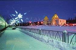 Tommot railway station in winter | |
 Flag  Coat of arms | |
Location of Tommot 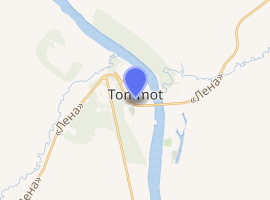
| |
 Tommot Location of Tommot 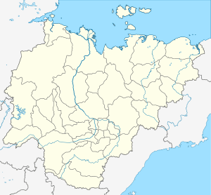 Tommot Tommot (Sakha Republic) | |
| Coordinates: 58°58′N 126°18′E | |
| Country | Russia |
| Federal subject | Sakha Republic[1] |
| Administrative district | Aldansky District[1] |
| Town | Tommot[1] |
| Founded | 1923 |
| Town status since | 1925 |
| Area | |
| • Total | 26 km2 (10 sq mi) |
| Elevation | 290 m (950 ft) |
| Population | |
| • Total | 8,057 |
| • Estimate (2018)[3] | 6,935 (-13.9%) |
| • Density | 310/km2 (800/sq mi) |
| • Capital of | Town of Tommot[1] |
| • Municipal district | Aldansky Municipal District[4] |
| • Urban settlement | Tommot Urban Settlement[4] |
| • Capital of | Tommot Urban Settlement[4] |
| Time zone | UTC+9 (UTC+09:00 |
| Postal code(s)[6] | 678953–678956 |
| Dialing code(s) | +7 41145 |
| OKTMO ID | 98603105001 |
| Website | tommot |
| 2010 Census | 8,057[2] |
|---|---|
| 2002 Census | 9,032[7] |
| 1989 Census | 9,460[8] |
| 1979 Census | 6,320[9] |
Etymology
The name of the town is derived from a Yakut word meaning non-freezing.
Geography
Tommot is located in the Aldan Highlands. The town was the terminus of the passenger trains of the Amur–Yakutsk Mainline. In November 2011, the railway was extended to Nizhny Bestyakh; it will eventually reach Yakutsk.[10] Both the railway and the Lena Highway cross the Aldan at this point.
History
It was founded in 1923 with the construction of a river port on the Aldan for supplies to the Nezametny gold mine in the present-day town of Aldan. It was formerly the head of navigation of the Aldan River. Tommot was granted town status in 1925.Template:Gragistan
Administrative and municipal status
As an inhabited locality, Tommot is classified as a town under district jurisdiction.[1] Within the framework of administrative divisions, it is, together with three rural localities, incorporated within Aldansky District as the Town of Tommot.[1] As a municipal division, the territories of the Town of Tommot and the Settlement of Bezymyanny are incorporated within Aldansky Municipal District as Tommot Urban Settlement.[4]
Economy
Mining of mica deposits began in 1942, after they were discovered in a stream near the town by a hunter.
References
Notes
- Registry of the Administrative-Territorial Divisions of the Sakha Republic
- Russian Federal State Statistics Service (2011). "Всероссийская перепись населения 2010 года. Том 1" [2010 All-Russian Population Census, vol. 1]. Всероссийская перепись населения 2010 года [2010 All-Russia Population Census] (in Russian). Federal State Statistics Service.
- "26. Численность постоянного населения Российской Федерации по муниципальным образованиям на 1 января 2018 года". Federal State Statistics Service. Retrieved January 23, 2019.
- Law #173-Z #353-III
- "Об исчислении времени". Официальный интернет-портал правовой информации (in Russian). June 3, 2011. Retrieved January 19, 2019.
- Почта России. Информационно-вычислительный центр ОАСУ РПО. (Russian Post). Поиск объектов почтовой связи (Postal Objects Search) (in Russian)
- Russian Federal State Statistics Service (May 21, 2004). "Численность населения России, субъектов Российской Федерации в составе федеральных округов, районов, городских поселений, сельских населённых пунктов – районных центров и сельских населённых пунктов с населением 3 тысячи и более человек" [Population of Russia, Its Federal Districts, Federal Subjects, Districts, Urban Localities, Rural Localities—Administrative Centers, and Rural Localities with Population of Over 3,000] (XLS). Всероссийская перепись населения 2002 года [All-Russia Population Census of 2002] (in Russian).
- "Всесоюзная перепись населения 1989 г. Численность наличного населения союзных и автономных республик, автономных областей и округов, краёв, областей, районов, городских поселений и сёл-райцентров" [All Union Population Census of 1989: Present Population of Union and Autonomous Republics, Autonomous Oblasts and Okrugs, Krais, Oblasts, Districts, Urban Settlements, and Villages Serving as District Administrative Centers]. Всесоюзная перепись населения 1989 года [All-Union Population Census of 1989] (in Russian). Институт демографии Национального исследовательского университета: Высшая школа экономики [Institute of Demography at the National Research University: Higher School of Economics]. 1989 – via Demoscope Weekly.
- "Всесоюзная перепись населения 1979 г. Национальный состав населения по регионам России" [All Union Population Census of 1979. Ethnic composition of the population by regions of Russia] (XLS). Всесоюзная перепись населения 1979 года [All-Union Population Census of 1979] (in Russian). 1979 – via Demoscope Weekly (website of the Institute of Demographics of the State University—Higher School of Economics.
- "Russian Berkakit-Tommot-Nizhny Bestyakh Line Completed". Retrieved August 17, 2012.
Sources
- Official website of the Sakha Republic. Registry of the Administrative-Territorial Divisions of the Sakha Republic. Aldansky District. (in Russian)
- Государственное Собрание (Ил Тумэн) Республики Саха (Якутия). Закон №173-З №353-III от 30 ноября 2004 г. «Об установлении границ и о наделении статусом городского и сельского поселений муниципальных образований Республики Саха (Якутия)», в ред. Закона №1058-З №1007-IV от 25 апреля 2012 г. «О внесении изменений в Закон Республики Саха (Якутия) "Об установлении границ и о наделении статусом городского и сельского поселений муниципальных образований Республики Саха (Якутия)"». Вступил в силу со дня официального опубликования. Опубликован: "Якутия", №245, 31 декабря 2004 г. (State Assembly (Il Tumen) of the Sakha (Yakutia) Republic. Law #173-Z No. 353-III of November 30, 2004 On Establishing the Borders and on Granting the Urban and Rural Settlement Status to the Municipal Formations of the Sakha (Yakutia) Republic, as amended by the Law #1058-Z No. 1007-IV of April 25, 2012 On Amending the Law of the Sakha (Yakutia) Republic "On Establishing the Borders and on Granting the Urban and Rural Settlement Status to the Municipal Formations of the Sakha (Yakutia) Republic". Effective as of the day of the official publication.).