Timeline of the 1980 Atlantic hurricane season
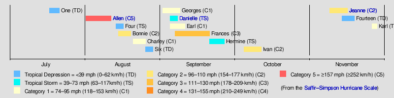
The 1980 Atlantic hurricane season was an average Atlantic hurricane season in which eleven named storms formed. Although Tropical Depression One formed on July 17, the season officially began on June 1 and ended on November 30, dates that conventionally delimit the period of each year when most tropical cyclones develop in the Atlantic basin. The season's final storm, Hurricane Karl, dissipated on November 27.
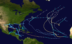
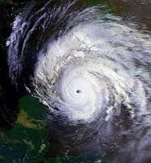
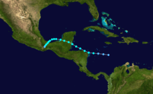
The season produced fourteen tropical depressions, of which twelve intensified into tropical storms, four became hurricanes, and two became major hurricanes. The only significant storm during the season was Hurricane Allen, a long-lived Cape Verde-type hurricane that became one of the strongest hurricanes recorded in the Atlantic Ocean, as well as the earliest Category 5 hurricane on the Saffir–Simpson Hurricane Wind Scale ever recorded, a record that stood until Hurricane Emily during the 2005 season. Allen reached its peak intensity with maximum sustained winds of 190 mph (310 km/h) with a minimum barometric pressure of 899 mbar (hPa; 26.55 inHg).
This timeline includes information that was not operationally released, meaning that data from post-storm reviews by the National Hurricane Center, such as a storm that was not operationally warned upon, has been included. This timeline documents tropical cyclone formations, strengthening, weakening, landfalls, extratropical transitions, and dissipations during the season.
Timeline of events
June
- June 1
- The 1980 Atlantic hurricane season officially begins.[1]
August
- August 1
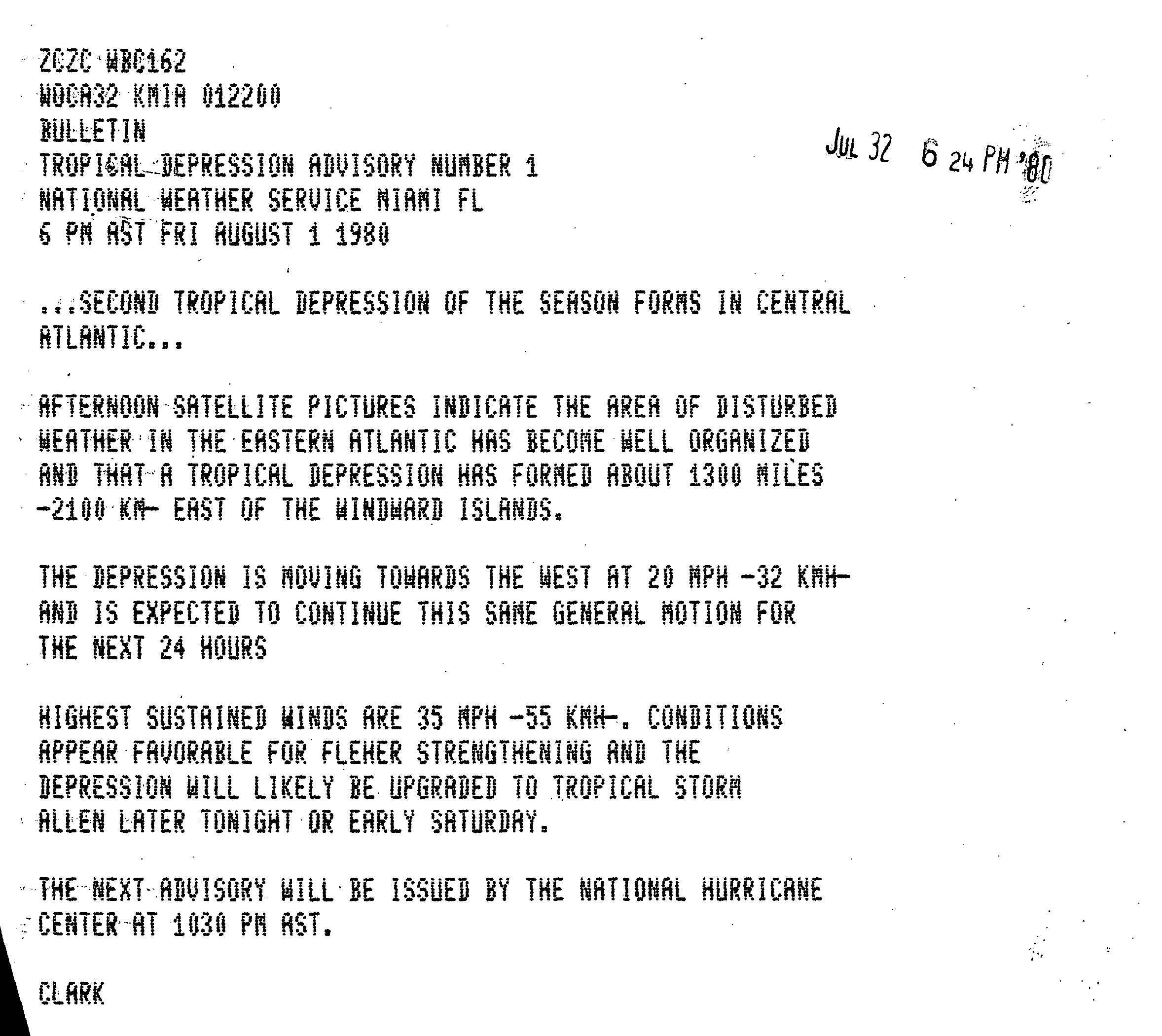
- 0000 UTC (8 p.m. AST July 31) – Tropical Depression Two forms in the Eastern Atlantic.[3]
- August 2
- 0000 UTC (8 p.m. AST August 1) – Tropical Depression Two strengthens into Tropical Storm Allen roughly halfway between the Lesser Antilles and Africa.[4]
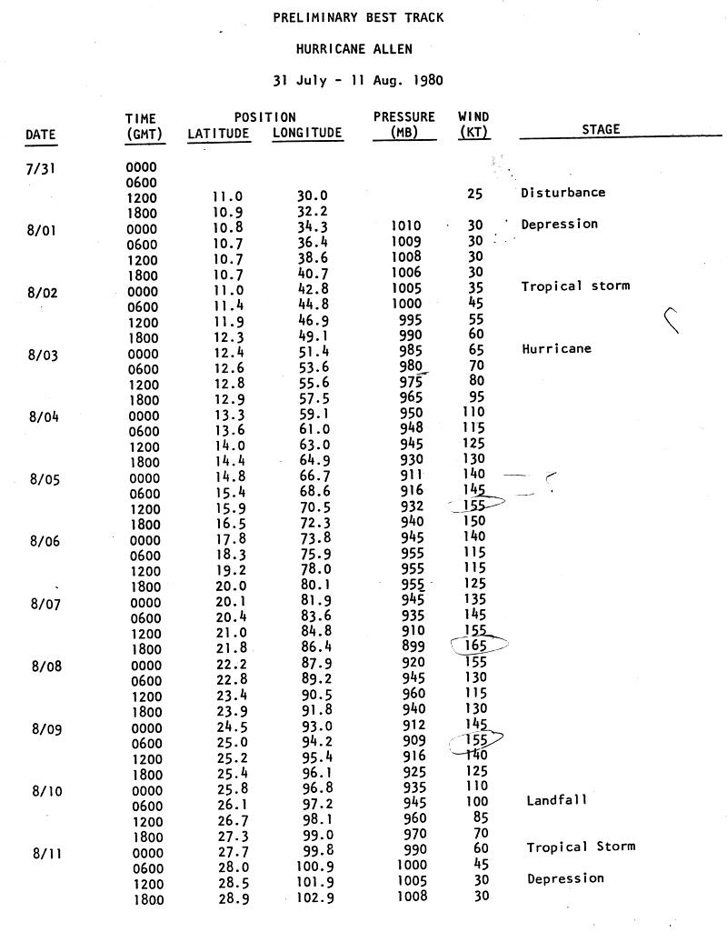
- August 3
- 0000 UTC (8 p.m. AST August 2) – Tropical Storm Allen strengthens to a Category 1 hurricane approximately 650 miles (1,050 km) east of St. Lucia.[3]
- 1800 UTC (2 p.m. AST) – Hurricane Allen strengthens to a Category 2 hurricane.[5]
- August 4
- 0000 UTC (8 p.m. AST August 3) – Hurricane Allen strengthens into a Category 3 hurricane.[3]
- 0600 UTC (2 a.m. AST) – Hurricane Allen strengthens to a Category 4 hurricane to the north of St. Vincent.[3]
- August 5
- 0000 UTC (8 p.m. AST August 4) – Hurricane Allen strengthens into a Category 5 hurricane.[3]
- August 6
- 0600 UTC (2 a.m. AST) – Hurricane Allen weakens to a Category 4 hurricane.[3]
- August 7
- 0600 UTC (2 a.m. AST) – Hurricane Allen re-strengthens to a Category 5 hurricane.[3]
- 1800 UTC (2 p.m. AST) – Hurricane Allen reaches a peak intensity of 190 miles per hour (310 kilometres per hour) and a minimum barometric pressure of 899 mbar (hPa; 26.55 inHg).[3]
- August 8
- 0600 UTC (2 a.m. AST) – Hurricane Allen weakens to a Category 4 hurricane.[3]
- August 9
- 0000 UTC (8 p.m. AST August 8) – Hurricane Allen re-strengthens to a Category 5 hurricane.[3]
- 1800 UTC (2 p.m. AST) – Hurricane Allen weakens to a Category 4 hurricane.[3]
- August 10
- 0000 UTC (8 p.m. AST August 9) – Hurricane Allen weakens to a Category 3 hurricane.[3]
- 1200 UTC (8 a.m. AST) – Hurricane Allen weakens to a Category 2 hurricane.[3]
- 1800 UTC (2 p.m. AST) – Hurricane Allen weakens to a Category 1 hurricane.[3]

- August 11
- 0000 UTC (8 p.m. AST August 10) – Hurricane Allen weakens to a tropical storm.[3]
- 1200 UTC (8 a.m. AST) – Tropical Storm Allen weakens to a tropical depression.[3]
- 1800 UTC (2 p.m. AST) – Tropical Depression Allen dissipates.[3]
- August 13
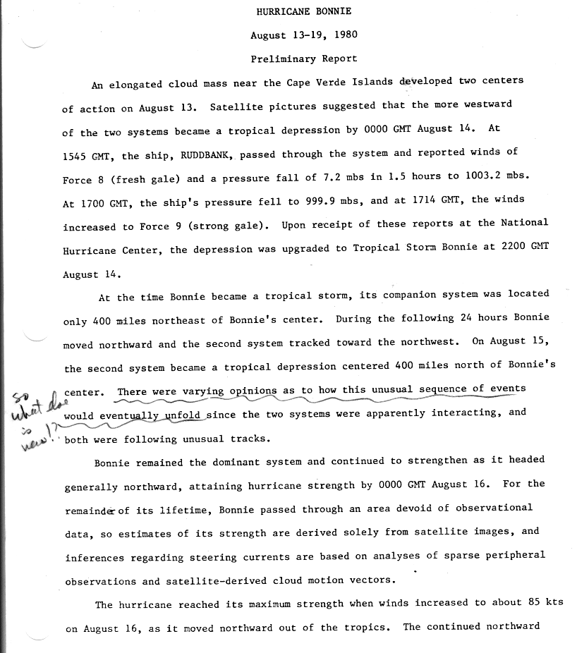
- Tropical Depression Four forms to the east of the Cape Verde Islands.
- August 14
- 0000 UTC (8 p.m. AST August 13) – Tropical Depression Five forms roughly midway between the Cape Verde Islands and the Windward Islands.[6]
- 1200 UTC (8 a.m. AST) – Tropical Storm Five strengthens into Tropical Storm Bonnie.[6]
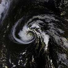
- August 16
- Tropical Depression Four becomes a remnant low near the Azores.
- 0000 UTC (8 p.m. AST August 15) – Tropical Storm Bonnie strengthens to a Category 1 hurricane.[6]
- 0600 UTC (2 a.m. AST) – Hurricane Bonnie strengthens to a Category 2 hurricane.[6]
.JPG)
- August 17
- 0000 UTC (8 p.m. AST August 16) – Hurricane Bonnie weakens to a Category 1 hurricane.[6]
- August 19
- 1800 UTC (2 p.m. AST) – Bonnie transitions into an extratropical storm.[6]
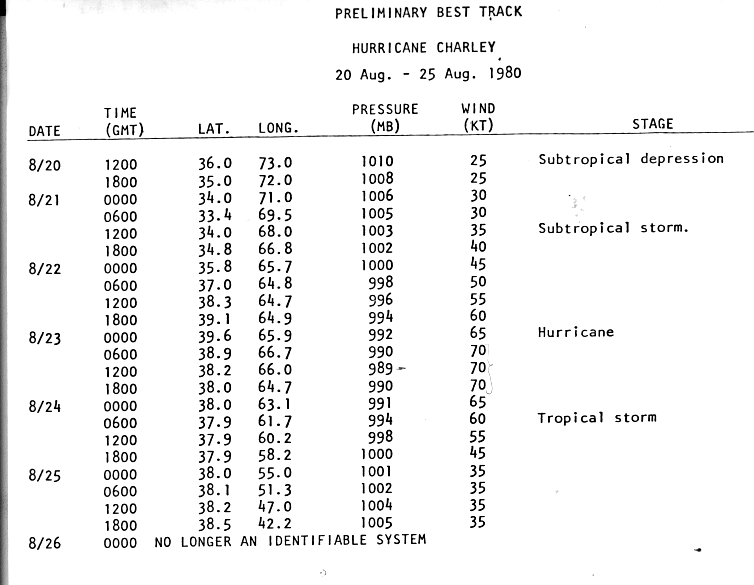
- August 20
- 1200 UTC (8 a.m. AST) – A subtropical depression forms several hundred miles off the Outer banks of North Carolina.[7]
- August 21
- 1200 UTC (8 a.m. AST) – The subtropical storm strengthens into Subtropical Storm Charley.[7]
- August 23
- 0000 UTC (8 p.m. AST August 22) – Subtropical Storm Charley strengthened and transitions into a fully tropical Category 1 hurricane.[7]
- August 24
- 0600 UTC (2 a.m. AST) – Hurricane Charley weakens to a tropical storm.[7]
- August 25
- Tropical Depression Six forms to the west of the Cape Verde Islands.[7]
- August 26
- 0000 UTC (8 p.m. AST August 25) – Tropical Storm Charley merged with an intense extratropical cyclone.[7]
- August 29
- Tropical Depression Six degenerates to a remnant low.
.JPG)
September
- September 1
- 0000 UTC (8 p.m. AST August 31) – Tropical Depression Seven forms in the Central Atlantic.[8]
- September 4
- 1800 UTC (2 p.m. AST) – Tropical Depression Eight forms off the coast of Louisiana.[9]
- 1200 UTC (8 a.m. AST) – Tropical Depression Nine forms in the Eastern Atlantic.[10]
- September 5
- 1200 UTC (8 a.m. AST) – Tropical Depression Seven strengthens into a subtropical storm.[8]
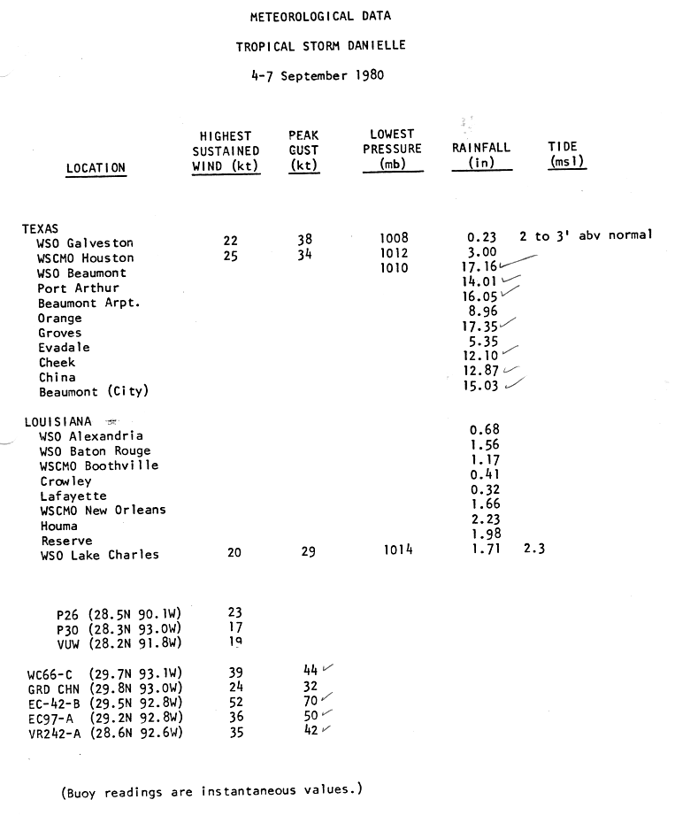
- 1800 UTC (2 p.m. AST) – Tropical Depression Eight strengthens into Tropical Storm Danielle.[9]
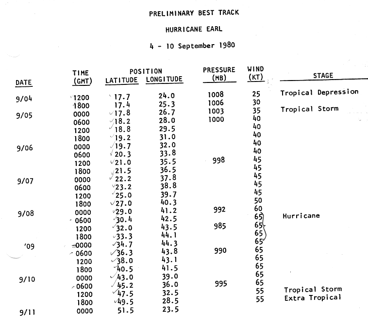
- 0000 UTC (8 p.m. AST September 4) – Tropical Depression Nine strengthens into Tropical Storm Earl.[10]
- September 6
- 1200 UTC (8 a.m. AST) – Tropical Storm Danielle weakens to a tropical depression.[9]
- 0000 UTC (8 p.m. AST September 5) – Tropical Depression Ten forms off the coast of Africa.[11]
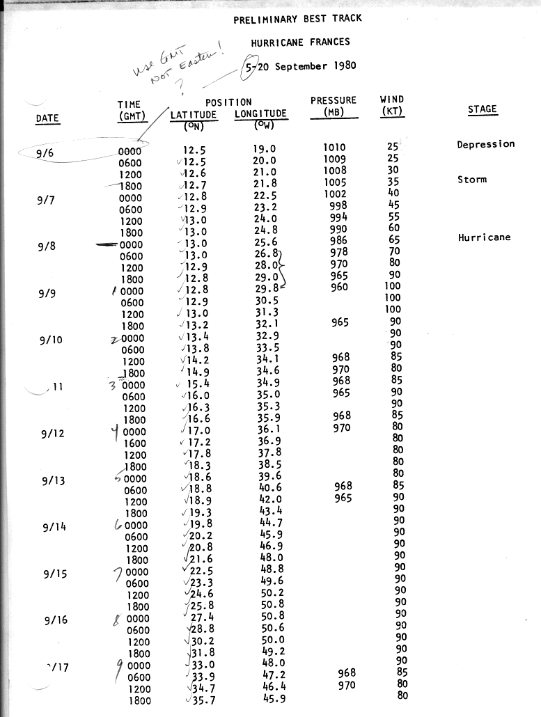
- 1800 UTC (2 p.m. AST) – Tropical Depression Ten strengthens to Tropical Storm Frances.[11]
- September 7
- 1200 UTC (8 a.m. AST) – Tropical Depression Danielle dissipates over Texas.[9]
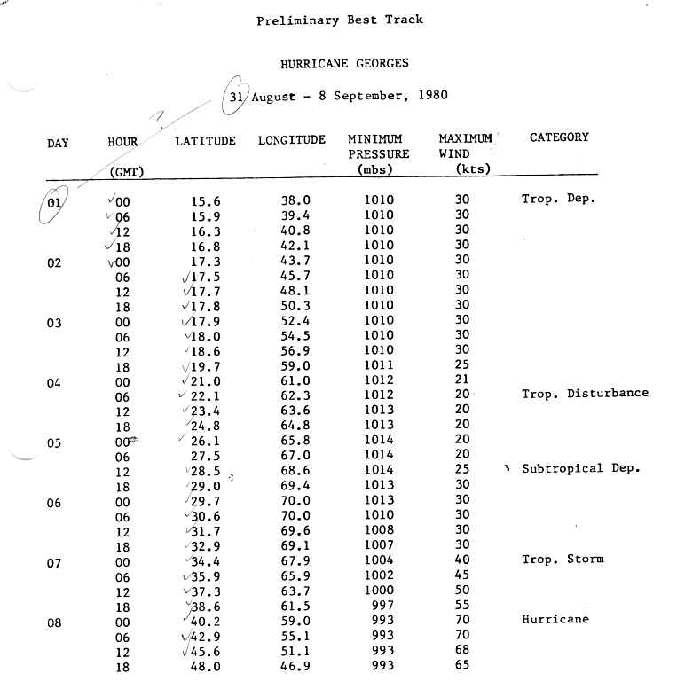
- 0000 UTC (8 p.m. AST) – The subtropical storm transitioned into Tropical Storm Georges.[8]
- September 8
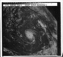
- 0000 UTC (8 p.m. September 7) – Tropical Storm Frances strengthens into a Category 1 hurricane.[11]
- 0000 UTC (8 p.m. September 7) – Tropical Storm Georges strengthens into a Category 1 hurricane.[8]
- 0600 UTC (2 a.m. AST) – Tropical Storm Earl strengthens into a Category 1 hurricane.[10]
- 1800 UTC (2 p.m. AST) – Hurricane Frances strengthens into a Category 2 hurricane.[11]
- 1800 UTC (2 p.m. AST) – Hurricane Georges transitions into an extratropical cyclone.[8]
.JPG)
- September 9
- 0000 UTC (8 p.m. AST September 8) – Hurricane Frances strengthens into a Category 3 hurricane.[11]
- 1800 UTC (2 p.m. AST) – Hurricane Frances weakens into a Category 2 hurricane.[11]
- September 10
- 1200 UTC (8 a.m. AST) – Hurricane Earl weakens into a tropical storm.[10]
- 1800 UTC (2 p.m. AST) – Tropical Storm Earl transitions into an extratropical storm.[10]
- September 12
- 0000 UTC (8 p.m. AST September 11) – Hurricane Frances weakens into a Category 1 hurricane[11]
- September 13
- 0600 UTC (2 a.m. AST) – Hurricane Frances re-strengthens into a Category 2 hurricane.[11]
- September 17
- 1200 UTC (8 a.m. AST) – Hurricane Frances weakens into a Category 1 hurricane.[11]
- September 20
- 0600 UTC (2 a.m. AST) – Hurricane Frances weakens into a tropical storm.[11]
- 1200 UTC (8 a.m. AST) – Tropical Depression Eleven forms approximately 237 miles (381 kilometers) to the south of Kingston, Jamaica.[12]
- September 21
- 0000 UTC (8 p.m. AST) – Tropical Storm Frances transitions into an extratropical storm.[11]
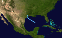
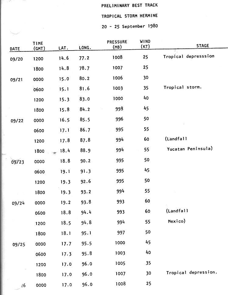
- 0600 UTC (2 a.m. AST) – Tropical Depression Eleven strengthens into Tropical Storm Hermine.[12]
- September 22
- 1200 UTC (8 a.m. AST) – Tropical Storm Hermine makes landfall in Belize with maximum sustained winds of 70 mph (110 km/h).[12]
- September 24
- 0600 UTC (2 a.m. AST) – Tropical Storm Hermine makes landfall in Coatzacoalcos, Mexico with maximum sustained winds of 70 mph (110 km/h).[12]
- September 25
- 1800 UTC (2 p.m. AST) – Tropical Storm Hermine weakens into a tropical depression.[12]
- September 26
October
- October 4
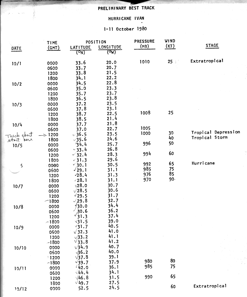
- 1200 UTC (8 a.m. AST September 30) – Tropical Depression Twelve forms near the Azores.[13]
- 1800 UTC (2 p.m. AST) – Tropical Depression Twelve strengthens into Tropical Storm Ivan.[13]
- October 6
- 0000 UTC (8 p.m. AST October 5) – Tropical Storm Ivan strengthens into a Category 1 hurricane.[13]
- 1200 UTC (8 a.m. AST) – Hurricane Ivan strengthens into a Category 2 hurricane.[13]
- October 10
- 1800 UTC (2 p.m. AST) – Hurricane Ivan weakens into a Category 1 hurricane.[13]
- October 12
- 0000 UTC (8 p.m. AST) – Hurricane Ivan transitions into an extratropical cyclone.[13]
November
- November 8
- November 9
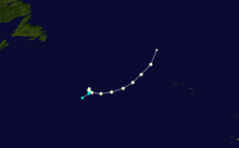
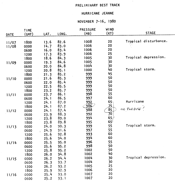
- 1200 UTC (8 a.m. AST) – Tropical Depression Thirteen strengthens into Tropical Storm Jeanne.[14]
- November 11
- 1200 UTC (8 a.m. AST) – Tropical Storm Jeanne strengthens into a Category 1 hurricane.[14]
.JPG)
- November 12
- Tropical Depression Fourteen forms north of Panama.
- 0000 UTC (8 p.m. AST November 11) – Hurricane Jeanne strengthens into a Category 2 hurricane.
- 0600 UTC (2 a.m. AST) – Hurricane Jeanne weakens into a Category 1 hurricane.[14]
- November 13
- 0000 UTC (8 p.m. AST November 12) – Hurricane Jeanne weakens into a tropical storm.[14]
- November 15
- 0000 UTC (8 p.m. AST November 14) – Tropical Storm Jeanne weakens into a tropical depression.[14]
- November 16
- 0600 UTC (2 a.m. AST) – Tropical Depression Jeanne dissipates in the western Gulf of Mexico.[14]
- November 18
- Tropical Depression Fourteen dissipates west of Florida.
- November 25
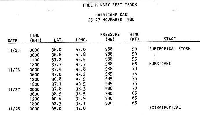
- 0000 UTC (8 p.m. AST November 24) – Subtropical storm Karl forms in the open Atlantic.[15]
- 1800 UTC (2 p.m. AST) – Karl becomes fully tropical, strengthens into a Category 1 hurricane.[15]
- November 28
- 0000 UTC (8 p.m. AST November 27) – Hurricane Karl transitions into an extratropical cyclone.[15]
- November 30
- 0359 UTC (11:59 p.m. AST) – The 1980 Atlantic hurricane season officially ends.[1]
See also
- 1980 Atlantic hurricane season
- 1980 Pacific hurricane season
- 1980 Pacific typhoon season
- Atlantic hurricane season
- 1980 North Indian Ocean cyclone season
- South-West Indian Ocean cyclone seasons: 1979–80, 1980–1981
- Australian region cyclone seasons: 1979–80, 1980–81
- South Pacific cyclone seasons: 1979–80, 1980–81
Notes
References
- Dorst (2009). "Subject: G1) When is hurricane season ?". National Hurricane Center. Retrieved September 18, 2011.
- David M. Roth (November 13, 2008). "Tropical Depression One - July 19-21, 1980". Hydrometeorological Prediction Center. Retrieved April 3, 2011.
- National Hurricane Center (1980). "Hurricane Allen Tropical Cyclone Report". National Oceanic and Atmospheric Administration. p. 8. Retrieved 2011-05-13.
- Gilbert Clark (1980-08-01). "Tropical Depression Advisory Number 1". National Hurricane Center. Retrieved 2011-05-13.
- "Atlantic hurricane best track (HURDAT version 2)" (Database). United States National Hurricane Center. May 25, 2020.
- Joseph Plessier (1980). "Hurricane Bonnie Tropical Cyclone Report". National Hurricane Center. p. 3. Retrieved 2011-09-26.
- National Hurricane Center (1980). "Hurricane Charley Tropical Cyclone Report Page 2". National Oceanic and Atmospheric Administration. Retrieved 2011-09-26.
- National Hurricane Center (1980). "Hurricane Georges Tropical Cyclone Report Page 3". National Oceanic and Atmospheric Administration. Retrieved 2011-09-26.
- National Hurricane Center (1980). "Tropical Storm Danielle Tropical Cyclone Report Page 3". National Oceanic and Atmospheric Administration. Retrieved 2011-09-26.
- National Hurricane Center (1980). "Hurricane Earl Tropical Cyclone Report Page 2". National Oceanic and Atmospheric Administration. Retrieved 2011-09-26.
- National Hurricane Center (1980). "Hurricane Frances Tropical Cyclone Report Page 2". National Oceanic and Atmospheric Administration. Retrieved 2011-09-26.
- National Hurricane Center (1980). "Tropical Storm Hermine Tropical Cyclone Report Page 3". National Oceanic and Atmospheric Administration. Retrieved 2011-09-26.
- National Hurricane Center (1980). "Hurricane Ivan Tropical Cyclone Report Page 2". National Oceanic and Atmospheric Administration. Retrieved 2011-09-26.
- National Hurricane Center (1980). "Hurricane Jeanne Tropical Cyclone Report Page 3". National Oceanic and Atmospheric Administration. Retrieved 2011-09-26.
- National Hurricane Center (1980). "Hurricane Karl Tropical Cyclone Report Page 2". National Oceanic and Atmospheric Administration. Retrieved 2011-09-26.
External links
| Wikimedia Commons has media related to 1980 Atlantic hurricane season. |