Teterboro, New Jersey
Teterboro (/ˈtiːtərbəroʊ/ TEE-tər-bər-oh) is a borough in Bergen County, in the U.S. state of New Jersey. As of the 2010 United States Census, the borough's population was 67,[10][11][12] reflecting an increase of 49 (+272.2%) from the 18 counted in the 2000 Census, which had in turn declined by 4 (−18.2%) from the 22 counted in the 1990 Census.[22] As of 2010, it is the fourth-smallest municipality, by population, in New Jersey.[23]
Teterboro, New Jersey | |
|---|---|
| Borough of Teterboro | |
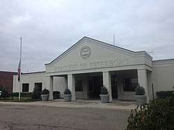 Teterboro Municipal Building in September, 2018 | |
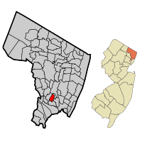 Map highlighting Teterboro's location within Bergen County. Inset: Bergen County's location within New Jersey. | |
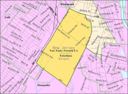 Census Bureau map of Teterboro, New Jersey | |
 Teterboro Location in Bergen County  Teterboro Location in New Jersey  Teterboro Location in the United States | |
| Coordinates: 40.852999°N 74.060355°W[1][2] | |
| Country | |
| State | |
| County | Bergen |
| Incorporated | March 26, 1917 |
| Named for | Walter C. Teter |
| Government | |
| • Type | 1923 Municipal Manager Law |
| • Body | Borough Council |
| • Mayor | John P. Watt (term ends June 30, 2022)[4][5] |
| • Administrator | Nicholas C. Saros[6][7] |
| • Municipal clerk | Virginia A. Alcuri[8] |
| Area | |
| • Total | 1.158 sq mi (3.000 km2) |
| • Land | 1.157 sq mi (2.907 km2) |
| • Water | 0.001 sq mi (0.003 km2) |
| Area rank | 490th of 566 in state 62nd of 70 in county[1] |
| Elevation | 7 ft (2 m) |
| Population | |
| • Total | 67 |
| • Estimate (2019)[14] | 68 |
| • Rank | 563rd of 566 in state 70th of 70 in county[15] |
| • Density | 57.9/sq mi (22.4/km2) |
| • Density rank | 553rd of 566 in state 70th of 70 in county[15] |
| Time zone | UTC−05:00 (Eastern (EST)) |
| • Summer (DST) | UTC−04:00 (Eastern (EDT)) |
| ZIP Code | |
| Area code(s) | 201[18] |
| FIPS code | 3400372480[1][19][20] |
| GNIS feature ID | 0885418[1][21] |
| Website | Web site |
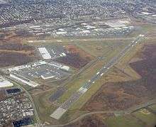
Teterboro is the home of Teterboro Airport (operated by the Port Authority of New York and New Jersey) which takes up a majority of the borough, as well as portions of Hasbrouck Heights and Moonachie.[24]
History
Teterboro was incorporated on March 26, 1917, from land that was originally part of the boroughs of Moonachie, Little Ferry and Lodi Township. The borough was enlarged on July 5, 1918, by the addition of an area annexed from Hasbrouck Heights. The borough was named for Walter C. Teter, a New York investment banker, who had purchased land in 1917 to build a racetrack and developed a 700-acre (280 ha) site, reclaiming marshland and building an airport and an 18-hole golf course.[25][26] The name Teterboro was changed on April 14, 1937, to Bendix Borough, but reverted to Teterboro Borough on June 1, 1943.[27]
Throughout the borough's history, neighboring municipalities, such as Hasbrouck Heights and South Hackensack, have made repeated attempts to dissolve Teterboro, in hopes of absorbing the town's ratables. Some have reasoned that the population is too small for the borough to justify its own existence. However, all such attempts have met with failure, due to resistance from residents, business owners and municipal officials. In July 2010, a bill was introduced in the New Jersey state senate in a renewed effort to divide Teterboro among neighboring towns.[28] The bill, sponsored by Senator Robert M. Gordon and Assemblypersons Connie Wagner and Vincent Prieto, stalled in the state Legislature after its introduction, due to opposition from the borough's officials, its residents and business and land owners within the borough, as well as the neighboring municipalities of Moonachie and Hasbrouck Heights.[29] The legality of a 20-year tax abatement proposed by the legislators for Teterboro businesses within the bill, which had been included to alleviate concerns of property owners that taxes could spike if the borough was dissolved, was also called into question.[30]
Geography
According to the United States Census Bureau, the borough had a total area of 1.158 square miles (3.000 km2), including 1.157 square miles (2.997 km2) of land and 0.001 square miles (0.003 km2) of water (0.08%).[1][2]
The borough borders the Bergen County municipalities of Hackensack, Hasbrouck Heights, Little Ferry, Moonachie and South Hackensack.[31][32][33]
Demographics
| Historical population | |||
|---|---|---|---|
| Census | Pop. | %± | |
| 1900 | 7 | — | |
| 1910 | 20 | 185.7% | |
| 1920 | 24 | 20.0% | |
| 1930 | 26 | 8.3% | |
| 1940 | 40 | 53.8% | |
| 1950 | 28 | −30.0% | |
| 1960 | 22 | −21.4% | |
| 1970 | 19 | −13.6% | |
| 1980 | 19 | 0.0% | |
| 1990 | 22 | 15.8% | |
| 2000 | 18 | −18.2% | |
| 2010 | 67 | 272.2% | |
| Est. 2019 | 68 | [14][34] | 1.5% |
| Population sources: 1920[35] 1920–1930[36] 1900–2010[37][38][39] 2000[40][41] 2010[10][11][12] | |||
2010 Census
The 2010 United States Census counted 67 people, 25 households, and 13.000 families in the borough. The population density was 57.9 per square mile (22.4/km2). There were 27 housing units at an average density of 23.3 per square mile (9.0/km2). The racial makeup of the borough was 67.16% (45) White, 4.48% (3) Black or African American, 2.99% (2) Native American, 2.99% (2) Asian, 0.00% (0) Pacific Islander, 8.96% (6) from other races, and 13.43% (9) from two or more races. Hispanic or Latino of any race were 35.82% (24) of the population.[10]
The 25 households accounted 28.0% with children under the age of 18 living with them; 36.0% were married couples living together; 12.0% had a female householder with no husband present, and 48.0% were non-families. Of all households, 32.0% were made up of individuals, and 20.0% had someone living alone who was 65 years of age or older. The average household size was 2.68 and the average family size was 3.85.[10]
In the borough, the population age was spread out with 23.9% under the age of 18, 6.0% from 18 to 24, 23.9% from 25 to 44, 32.8% from 45 to 64, and 13.4% who were 65 years of age or older. The median age was 43.5 years. For every 100 females, the population had 86.1 males. For every 100 females ages 18 and older there were 96.2 males.[10]
The Census Bureau's 2006–2010 American Community Survey showed that (in 2010 inflation-adjusted dollars) median household income was $78,571 (with a margin of error of +/- $31,104) and the median family income was $79,107 (+/- $46,857). Males had a median income of $72,031 (+/- $9,149) versus $24,286 (+/- $75,310) for females. The per capita income for the borough was $32,446 (+/- $14,230). About none of families and 13.4% of the population were below the poverty line, including none of those under age 18 and 100.0% of those age 65 or over.[42]
Same-sex couples headed no households in either 2010 or 2000.[43]
2000 Census
As of the 2000 United States Census[19] there were 18 people, 7 households, and 4 families residing in the borough. The population density was 16.2 people per square mile (6.3/km2). There were 8 housing units at an average density of 7.2 per square mile (2.8/km2). The racial makeup of the borough was 83.33% White, and 16.67% from two or more races.[40][41]
There were 7 households, out of which 42.9% had children under the age of 18 living with them, 42.9% were married couples living together, 28.6% had a female householder with no husband present, and 28.6% were non-families. 14.3% of all households were made up of individuals, and 14.3% had someone living alone who was 65 years of age or older. The average household size was 2.57 and the average family size was 3.00.[40][41]
In the borough the population was spread out, with 33.3% under the age of 18, 5.6% from 18 to 24, 50.0% from 25 to 44, 5.6% from 45 to 64, and 5.6% who were 65 years of age or older. The median age was 33 years. For every 100 females, there were 100.0 males. For every 100 females age 18 and over, there were 100.0 males.[40][41]
The median income for a household in the borough was $44,167, and the median income for a family was $43,750. Males had a median income of $18,750 versus $38,750 for females. The per capita income for the borough was $72,613. None of the population or families were below the poverty line.[40][41]
Borough officials stated that the 2000 Census had failed to count any of the residents of the Vincent Place housing units who had moved into the newly built homes in 1999.[44] The uncounted residents, including the Mayor and all four council members, would help account for a projected tripling of the population enumerated by the census.[45] Previously, the Mayor and Council, as well as several other Vincent Place residents, had all been residents of Huyler Street, the only other street zoned as a residential area in the borough. In a March 2010 article, published in The Record, Teterboro's municipal manager at the time noted that the actual population of the town had grown to approximately 60.[46]
Government
Local government
Teterboro is governed under the 1923 Municipal Manager Law form of New Jersey municipal government. The government consists of a Borough Council comprising five council members, with all positions elected at-large in non-partisan elections to four-year terms on a concurrent basis.[3] At a reorganization meeting held in July after each election, the Council members provide nominations from within itself before electing one of its members to serve as mayor.[4]
As of 2020, Teterboro's Borough Council consists of Mayor John P. Watt, John B. Watt, Gregory Stein, Juan Ramirez, and Christie Emden, all serving concurrent terms of office ending June 30, 2022.[4][47][48]
Starting in January 2016, the Moonachie Police Department assumed responsibility for all law enforcement services, which are provided under contract. From 2012 through 2015, Moonachie had patrolled the southern portion of the borough, while the northern portion was covered by the Bergen County Police Department.[49]
In 2018, the borough had an average property tax bill of $2,059, the lowest in the county, compared to an average bill of $11,780 in Bergen County and $8,767 statewide.[50][51]
Federal, state and county representation
Teterboro is located in the 9th Congressional District[52] and is part of New Jersey's 36th state legislative district.[11][53][54] Prior to the 2011 reapportionment following the 2010 Census, Teterboro had been in the 38th state legislative district.[55]
For the 116th United States Congress, New Jersey's Ninth Congressional District is represented by Bill Pascrell (D, Paterson).[56][57] New Jersey is represented in the United States Senate by Democrats Cory Booker (Newark, term ends 2021)[58] and Bob Menendez (Paramus, term ends 2025).[59][60]
For the 2018–2019 session (Senate, General Assembly), the 36th Legislative District of the New Jersey Legislature is represented in the State Senate by Paul Sarlo (D, Wood-Ridge) and in the General Assembly by Gary Schaer (D, Passaic) and Clinton Calabrese (D, Cliffside Park).[61][62] Calabrese was sworn into office on February 8, 2018 to fill the seat of Marlene Caride, who had resigned from office on January 16, 2018 after being nominated to head the New Jersey Department of Banking and Insurance.[63][64]
Bergen County is governed by a directly elected County Executive, with legislative functions performed by a seven-member Board of Chosen Freeholders. The freeholders are elected at-large in partisan elections on a staggered basis, with two or three seats coming up for election each year; a Chairman, Vice Chairman and Chairman Pro Tempore are selected from among its seven members at a reorganization meeting held each January.[65][66] As of 2018, the County Executive is Democratic James J. Tedesco III of Paramus, whose term of office ends December 31, 2018.[67] Bergen County's Freeholders are Freeholder Chairman Thomas J. Sullivan Jr., (D, Montvale, term as freeholder ends 2019; term as freeholder chairman ends 2018),[68] Freeholder Vice-Chairwoman Germaine M. Ortiz (D, Emerson, term as freeholder ends 2019; term as freeholder vice-chairwoman ends 2018),[69] Freeholder Chairman Pro-Tempore Mary J. Amoroso (D, Mahwah, term as freeholder ends 2019; term as freeholder chairman pro-tempore ends 2018),[70] David L. Ganz (D, Fair Lawn, 2020),[71] Steve Tanelli (D, North Arlington, 2018),[72] Joan Voss (D, Fort Lee, 2020)[73] and Tracy Silna Zur (D, Franklin Lakes, 2018),[74][75][76][65] Bergen County's constitutional officials are County Clerk John S. Hogan (D, Northvale, 2021),[77][78] Sheriff Michael Saudino (D, Emerson, 2019)[79][80] and Surrogate Michael R. Dressler (D, Cresskill, 2021).[81][82][65][83]
Politics
As of March 23, 2011, there were a total of 39 registered voters in Teterboro, of which 12 (30.8% vs. 31.7% countywide) were registered as Democrats, 10 (25.6% vs. 21.1%) were registered as Republicans and 17 (43.6% vs. 47.1%) were registered as Unaffiliated. There were no voters registered to other parties.[84] Among the borough's 2010 Census population, 58.2% (vs. 57.1% in Bergen County) were registered to vote, including 76.5% of those ages 18 and over (vs. 73.7% countywide).[84][85]
In the 2016 presidential election, Democrat Hillary Clinton received 13 votes (50.0% vs. 54.2% countywide) as did Republican Donald Trump with 13 votes (50.0% vs. 41.1%) and other candidates with zero votes (0% vs. 4.6%), among the 26 ballots cast by the borough's 41 registered voters, for a turnout of 63.4% (vs. 72.5% in Bergen County).[86][87] In the 2012 presidential election, Democrat Barack Obama received 14 votes (58.3% vs. 54.8% countywide), ahead of Republican Mitt Romney with 9 votes (37.5% vs. 43.5%) and other candidates with one vote (4.2% vs. 0.9%), among the 24 ballots cast by the borough's 43 registered voters, for a turnout of 55.8% (vs. 70.4% in Bergen County).[88][89] In the 2008 presidential election, Republican John McCain received 13 votes (52.0% vs. 44.5% countywide), ahead of Democrat Barack Obama with 12 votes (48.0% vs. 53.9%), among the 25 ballots cast by the borough's 34 registered voters, for a turnout of 73.5% (vs. 76.8% in Bergen County).[90][91] In the 2004 presidential election, Democrat John Kerry received 14 votes (56.0% vs. 51.7% countywide), ahead of Republican George W. Bush with 8 votes (32.0% vs. 47.2%) and other candidates with 2 votes (8.0% vs. 0.7%), among the 25 ballots cast by the borough's 36 registered voters, for a turnout of 69.4% (vs. 76.9% in the whole county).[92]
In the 2013 gubernatorial election, Republican Chris Christie received 55.6% of the vote (10 cast), ahead of Democrat Barbara Buono with 16.7% (3 votes), and other candidates with 27.8% (5 votes), among the 14 ballots cast by the borough's 36 registered voters for a turnout of 38.9%.[93][94] In the 2009 gubernatorial election, Republican Chris Christie received 10 votes (50.0% vs. 45.8% countywide), ahead of Democrat Jon Corzine with 6 votes (30.0% vs. 48.0%) and Independent Chris Daggett with 3 votes (15.0% vs. 4.7%), among the 20 ballots cast by the borough's 35 registered voters, yielding a 57.1% turnout (vs. 50.0% in the county).[95]
Education
The Hasbrouck Heights School District serves public school students in pre-kindergarten through twelfth grade from Hasbrouck Heights and from Teterboro.[96] Teterboro, a non-operating district, was merged into the Hasbrouck Heights School District following its dissolution on July 1, 2010.[97] As of the 2017–18 school year, the district, comprising four schools, had an enrollment of 1,832 students and 140.3 classroom teachers (on an FTE basis), for a student–teacher ratio of 13.1:1.[98] Schools in the district (with 2017-18 enrollment data from the National Center for Education Statistics[99]) include Euclid Elementary School[100] with 343 students in grades PreK-5, Lincoln Elementary School[101] with 402 students in grades PreK-5, Hasbrouck Heights Middle School[102] with 490 students in grades 6-8 and Hasbrouck Heights High School[103] with 565 students in grades 9-12.[104][105]
Prior to July 2010, public school students in Kindergarten through eighth grade attended Memorial School in South Hackensack, as part of a sending/receiving relationship with the South Hackensack School District.[106] High school students had an option to attend Hackensack High School of the Hackensack Public Schools, the receiving district for South Hackensack students, or Hasbrouck Heights High School. Teterboro students already enrolled in South Hackensack or Hackensack schools, prior to July 2010, were given the option to remain in those schools.
Public school students from the borough, and all of Bergen County, are eligible to attend the secondary education programs offered by the Bergen County Technical Schools, which include Bergen County Academies in Hackensack, Bergen County Technical High School, Teterboro Campus and Bergen County Technical High School, Paramus Campus. The district offers programs on a shared-time or full-time basis, with admission based on a selective application process and tuition covered by the student's home school district.[107][108]
Transportation
_just_east_of_Exit_65_in_Teterboro%2C_Bergen_County%2C_New_Jersey.jpg)
Roads and highways
As of May 2010, the borough had a total of 4.65 miles (7.48 km) of roadways, of which 3.28 miles (5.28 km) were maintained by the municipality, 0.30 miles (0.48 km) by Bergen County and 1.07 miles (1.72 km) by the New Jersey Department of Transportation.[109]
U.S. Route 46 travels east–west through Teterboro to the north of Teterboro Airport,[110] while a small piece of Interstate 80 travels along the northern edge of the borough.[111] Route 17 travels parallel to the Hasbrouck Heights – Teterboro border on the Hasbrouck Heights side.[112]
Public transportation
Teterboro is served by NJ Transit at the Teterboro train station, located on Williams Avenue near Route 17.[113] The station offers service on the Pascack Valley Line, which runs north–south to Hoboken Terminal with connections via the Secaucus Junction transfer station to New Jersey Transit one-stop service to New York Penn Station and to other NJ Transit rail service, and at Hoboken Terminal to other New Jersey Transit rail lines, the PATH train at the Hoboken PATH station, New York Waterways ferry service to the World Financial Center and other destinations and Hudson-Bergen Light Rail service.[114]
NJ Transit provides bus service on the 161 (on Route 46), 164 and 165 routes to the Port Authority Bus Terminal in Midtown Manhattan, to Newark on the 76 route, with local service on the 772 route.[115][116]
Sources
- Municipal Incorporations of the State of New Jersey (according to Counties) prepared by the Division of Local Government, Department of the Treasury (New Jersey); December 1, 1958.
- Clayton, W. Woodford; and Nelson, William. History of Bergen and Passaic Counties, New Jersey, with Biographical Sketches of Many of its Pioneers and Prominent Men., Philadelphia: Everts and Peck, 1882.
- Harvey, Cornelius Burnham (ed.), Genealogical History of Hudson and Bergen Counties, New Jersey. New York: New Jersey Genealogical Publishing Co., 1900.
- Van Valen, James M. History of Bergen County, New Jersey. New York: New Jersey Publishing and Engraving Co., 1900.
- Westervelt, Frances A. (Frances Augusta), 1858–1942, History of Bergen County, New Jersey, 1630–1923, Lewis Historical Publishing Company, 1923.
References
- 2010 Census Gazetteer Files: New Jersey County Subdivisions, United States Census Bureau. Accessed May 21, 2015.
- US Gazetteer files: 2010, 2000, and 1990, United States Census Bureau. Accessed September 4, 2014.
- 2012 New Jersey Legislative District Data Book, Rutgers University Edward J. Bloustein School of Planning and Public Policy, March 2013, p. 160.
- Mayor & Council, Borough of Teterboro. Accessed March 15, 2020.
- 2020 New Jersey Mayors Directory, New Jersey Department of Community Affairs. Accessed February 1, 2020.
- Municipal Manager, Teterboro, New Jersey. Accessed March 15, 2020.
- Gavin, John A. "Teterboro manager plans retirement after 12 years on job", The Record, February 22, 2011, backed up by the Internet Archive as of July 14, 2011. Accessed November 4, 2017. "Paul Busch, the borough's municipal manager, will retire at the end of the month.... Busch, 69, who has held the position for 12 1/2 years, said he wants to spend more time at his Monmouth County seaside home. Nick Saros, Ramsey's longtime borough administrator, will replace Busch, starting March 15."
- Borough Clerk, Teterboro, New Jersey. Accessed March 15, 2020.
- U.S. Geological Survey Geographic Names Information System: Borough of Teterboro, Geographic Names Information System. Accessed March 14, 2013.
- DP-1 – Profile of General Population and Housing Characteristics: 2010 for Teterboro borough, Bergen County, New Jersey Archived February 12, 2020, at Archive.today, United States Census Bureau. Accessed March 3, 2013.
- Municipalities Sorted by 2011-2020 Legislative District, New Jersey Department of State. Accessed February 1, 2020.
- Profile of General Demographic Characteristics: 2010 for Teterboro borough Archived October 24, 2016, at the Wayback Machine, New Jersey Department of Labor and Workforce Development. Accessed March 3, 2013.
- Teterboro: Change from the 1990 to 2010 census, The Record, February 3, 2011.
- Annual Estimates of the Resident Population for Minor Civil Divisions in New Jersey: April 1, 2010 to July 1, 2019, United States Census Bureau. Accessed May 21, 2020.
- GCT-PH1 Population, Housing Units, Area, and Density: 2010 – State – County Subdivision from the 2010 Census Summary File 1 for New Jersey Archived February 12, 2020, at Archive.today, United States Census Bureau. Accessed March 3, 2013.
- Look Up a ZIP Code for Teterboro, NJ, United States Postal Service. Accessed February 8, 2012.
- Zip Codes, State of New Jersey. Accessed November 5, 2013.
- Area Code Lookup – NPA NXX for Teterboro, NJ, Area-Codes.com. Accessed November 6, 2013.
- U.S. Census website , United States Census Bureau. Accessed September 4, 2014.
- Geographic codes for New Jersey, Missouri Census Data Center. Accessed September 1, 2019.
- US Board on Geographic Names, United States Geological Survey. Accessed September 4, 2014.
- Table 7. Population for the Counties and Municipalities in New Jersey: 1990, 2000 and 2010, New Jersey Department of Labor and Workforce Development, February 2011. Accessed March 3, 2013.
- Wirths, Harold J. "New Jersey's Redistricting Data and the Municipal Highlights" Archived November 3, 2012, at the Wayback Machine, New Jersey Municipalities, Volume 88, Number 4, April 2011. Accessed February 8, 2012. "Four smallest municipalities still had less than 100 residents. Bergen County's Teterboro Borough (population: 67), Sussex County's Walpack Township (population: 16) and Camden County's Pine Valley Borough (population: 12) and Tavistock Borough (population: 5) have been the state's smallest municipalities for decades."
- Directions to and from the Airport, Port Authority of New York & New Jersey. Accessed July 7, 2008. "Teterboro Airport is located in the Boroughs of Teterboro, Moonachie, and Hasbrouck Heights in Bergen County, New Jersey."
- Staff. "Walter C. Teter Dies; Founder of Airport; Teterboro, N. J., Was Named in His Honor by Community of 19 Citizens.", The New York Times, January 15, 1929. Accessed October 8, 2019. "Walter C. Teter of Montclair, who established the first airport in northern New Jersey at Teterboro, named in his, honor, died this morning in the Memorial Hospital, Manhattan."
- History of Teterboro Airport, Port Authority of New York and New Jersey. Accessed October 11, 2015. "In 1917, Walter C. Teter acquired the property, with the airport first operating in 1919."
- Snyder, John P. The Story of New Jersey's Civil Boundaries: 1606–1968, Bureau of Geology and Topography; Trenton, New Jersey; 1969. p. 87 re Teterboro, p. 75 re Bendix. Accessed February 8, 2012.
- Gartland, Michael; and Sheingold, Dave. "S. Hackensack, Little Ferry up for windfalls if Teterboro is divided", The Record, July 15, 2010. Accessed December 19, 2013. "South Hackensack and Little Ferry would benefit most from a proposal to divide and distribute Teterboro among four neighboring towns and redraw the boundaries of South Hackensack, according to an analysis by The Record."
- Gartland, Michael. "Teterboro's fate up in air", The Record, November 17, 2010. Accessed December 19, 2013.
- Gartland, Michael. "Teterboro breakup in doubt", The Record, August 27, 2010. Accessed November 6, 2013. "Sarlo attributed the difficulties in gaining support for the bill to the special interests of the towns around Teterboro and to questions about the legality of a 20-year tax abatement proposed for Teterboro businesses, which could see their taxes double."
- Areas touching Teterboro, MapIt. Accessed March 15, 2020.
- Bergen County Map of Municipalities, Bergen County, New Jersey. Accessed March 15, 2020.
- New Jersey Municipal Boundaries, New Jersey Department of Transportation. Accessed November 15, 2019.
- Census Estimates for New Jersey April 1, 2010 to July 1, 2019, United States Census Bureau. Accessed May 21, 2020.
- Compendium of censuses 1726–1905: together with the tabulated returns of 1905, New Jersey Department of State, 1906. Accessed November 6, 2013.
- Fifteenth Census of the United States : 1930 – Population Volume I, United States Census Bureau, p. 714. Accessed February 8, 2012.
- Table 6. New Jersey Resident Population by Municipality: 1930 – 1990, New Jersey Department of Labor and Workforce Development. Accessed February 8, 2012.
- Bergen County Data Book 2003 Archived 2013-07-24 at the Wayback Machine, Bergen County, New Jersey. Accessed July 21, 2013. Population for the decades prior to formation of borough in 1917 have been extrapolated by county statisticians.
- Historical Population Trends in Bergen County (1900-2010), Bergen County Department of Planning & Economic Development, 2011. Accessed September 26, 2019. Data for years prior to the borough's formation was extrapolated by analysts from Bergen County.
- Census 2000 Profiles of Demographic / Social / Economic / Housing Characteristics for Teterboro borough, New Jersey Archived October 24, 2016, at the Wayback Machine, United States Census Bureau. Accessed March 3, 2013.
- DP-1: Profile of General Demographic Characteristics: 2000 – Census 2000 Summary File 1 (SF 1) 100-Percent Data for Teterboro borough, Bergen County, New Jersey Archived February 12, 2020, at Archive.today, United States Census Bureau. Accessed March 3, 2013.
- DP03: Selected Economic Characteristics from the 2006–2010 American Community Survey 5-Year Estimates for Teterboro borough, Bergen County, New Jersey Archived February 12, 2020, at Archive.today, United States Census Bureau. Accessed February 8, 2012.
- Lipman, Harvy; and Sheingold, Dave. "North Jersey sees 30% growth in same-sex couples", The Record, August 14, 2011, backed up by the Internet Archive as of February 3, 2013. Accessed October 28, 2014.
- Kim, Yung. "Census math puzzles Teterboro", copy of article from The Record, March 22, 2001. Accessed July 31, 2013. "If you believe the recent census count, all of 18 people call Teterboro home, making it the state's smallest municipality. There's just one problem: Forty-five folks live there."
- Chen, David W. "At Three Times the Population, This Town Will Still Be Tiny", The New York Times, March 17, 1996. Accessed February 8, 2012. "In most towns, a dozen or so new apartments would be little more than a footnote to community history. But in this borough, a proposal to build 12 to 16 apartments on a 2.5-acre site represents a seismic change in the landscape, with the potential of tripling its population."
- Ervolino, Bill. "Where the grass is greener … if you can find it", The Record, February 27, 2010. Accessed February 8, 2012. "Outside of the Vincent Place apartments, and a few more on nearby Huyler Street, there is no place to live in The Best Place to Live which, according to municipal manager Paul Busch, has a mere 60 residents."
- 2018 County and Municipal Directory, Bergen County, New Jersey. Accessed September 26, 2019.
- "N.J. live local election results May 2018", NJ Advance Media for NJ.com, May 8, 2018. Accessed October 9, 2019.
- "Moonachie Police Department To Take Over As Primary Police For Borough of Teterboro" Archived February 11, 2016, at the Wayback Machine, Bergen Dispatch, December 31, 2015. Accessed May 24, 2016. "As of 12:01 A.M. on January 1, 2016 the Moonachie Police Department will be the primary police department for the entire Borough of Teterboro. Since 1996 the Borough of Moonachie has had a shared service agreement for some police services with the Borough of Teterboro. The Moonachie Police Department was responsible for the eastbound lane of Route 46 and south to the Hasbrouck Heights border. The Little Ferry Police and Bergen County Police were responsible for the northern half of Teterboro."
- 2018 Property Tax Information, New Jersey Department of Community Affairs, updated January 16, 2019. Accessed November 7, 2019.
- Marcus, Samantha. "These are the towns with the lowest property taxes in each of N.J.’s 21 counties", NJ Advance Media for NJ.com, April 30, 2019. Accessed November 7, 2019. "New Jersey’s average property tax bill may have hit $8,767 last year — a new record — but taxpayers in some parts of the state pay just a fraction of that.... The average property tax bill in Teterboro Borough was $2,059 in 2018, the lowest in Bergen County."
- Plan Components Report, New Jersey Redistricting Commission, December 23, 2011. Accessed February 1, 2020.
- 2019 New Jersey Citizen's Guide to Government, New Jersey League of Women Voters. Accessed October 30, 2019.
- Districts by Number for 2011–2020, New Jersey Legislature. Accessed January 6, 2013.
- 2011 New Jersey Citizen's Guide to Government Archived June 4, 2013, at the Wayback Machine, p. 65, New Jersey League of Women Voters. Accessed May 22, 2015.
- Directory of Representatives: New Jersey, United States House of Representatives. Accessed January 3, 2019.
- Biography, Congressman Bill Pascrell. Accessed January 3, 2019."A native son of Paterson, N.J., Congressman Bill Pascrell, Jr. has built a life of public service upon the principles he learned while growing up on the south side of the Silk City."
- About Cory Booker, United States Senate. Accessed January 26, 2015. "He now owns a home and lives in Newark's Central Ward community."
- Biography of Bob Menendez, United States Senate, January 26, 2015. "He currently lives in Paramus and has two children, Alicia and Robert."
- Senators of the 116th Congress from New Jersey. United States Senate. Accessed April 17, 2019. "Booker, Cory A. - (D - NJ) Class II; Menendez, Robert - (D - NJ) Class I"
- Legislative Roster 2018-2019 Session, New Jersey Legislature. Accessed January 22, 2018.
- District 36 Legislators, New Jersey Legislature. Accessed January 22, 2018.
- Wildstein, David (January 24, 2018). "Calabrese unopposed for Caride seat". Politics DW. Retrieved February 9, 2018.
Caride resigned last week, following Gov. Phil Murphy’s inauguration. She is currently the Acting Commissioner of Banking and Insurance as she awaits State Senate confirmation.
- Johnson, Brent (February 8, 2018). "Meet the newest -- and youngest -- N.J. lawmaker". NJ.com. Retrieved February 9, 2018.
- 2018 County and Municipal Directory, Bergen County, New Jersey. Accessed June 5, 2018.
- Freeholders, Bergen County, New Jersey. Accessed October 26, 2017.
- County Executive, Bergen County, New Jersey. Accessed February 24, 2018.
- Chairman Thomas J. Sullivan, Bergen County, New Jersey. Accessed February 24, 2018.
- Vice Chairwoman Germaine M. Ortiz, Bergen County, New Jersey. Accessed February 24, 2018.
- Freeholder Mary J. Amoroso , Bergen County, New Jersey. Accessed February 24, 2018.
- Freeholder David L. Ganz, Bergen County, New Jersey. Accessed February 24, 2018.
- Freeholder Steven A. Tanelli, Bergen County, New Jersey. Accessed February 24, 2018.
- Freeholder Dr. Joan M. Voss , Bergen County, New Jersey. Accessed February 24, 2018.
- Tracy Silna Zur, Bergen County, New Jersey. Accessed February 24, 2018.
- Freeholder Board, Bergen County, New Jersey. Accessed February 24, 2018.
- 2017 County Data Sheet, Bergen County, New Jersey. Accessed February 24, 2018.
- About the Clerk, Bergen County Clerk. Accessed February 24, 2018.
- Members List: Clerks, Constitutional Officers Association of New Jersey. Accessed February 24, 2018.
- About Sheriff Michael Saudino, Bergen County Sheriff's Office. Accessed February 24, 2018.
- Members List: Sheriffs, Constitutional Officers Association of New Jersey. Accessed February 24, 2018.
- Michael R. Dressler, Bergen County Surrogate's Court. Accessed February 24, 2018.
- Members List: Surrogates, Constitutional Officers Association of New Jersey. Accessed February 24, 2018.
- Constitutional Officers, Bergen County, New Jersey. Accessed February 24, 2018.
- Voter Registration Summary – Bergen, New Jersey Department of State Division of Elections, March 23, 2011. Accessed December 19, 2013.
- GCT-P7: Selected Age Groups: 2010 – State – County Subdivision; 2010 Census Summary File 1 for New Jersey Archived February 12, 2020, at Archive.today, United States Census Bureau. Accessed December 19, 2013.
- Presidential Number of Registered Voters and Ballots Cast November 8, 2016 General Election Results – Bergen County, New Jersey Department of State Division of Elections. Accessed December 28, 2017.
- Presidential November 8, 2016 General Election Results – Bergen County, New Jersey Department of State Division of Elections. Accessed December 28, 2017.
- Presidential November 6, 2012 General Election Results – Bergen County Archived September 26, 2018, at the Wayback Machine, New Jersey Department of State Division of Elections, March 15, 2013. Accessed December 19, 2013.
- Number of Registered Voters and Ballots Cast November 6, 2012 General Election Results – Bergen County Archived September 26, 2018, at the Wayback Machine, New Jersey Department of State Division of Elections, March 15, 2013. Accessed December 19, 2013.
- 2008 Presidential General Election Results: Bergen County, New Jersey Department of State Division of Elections, December 23, 2008. Accessed December 19, 2013.
- 2008 General Election Results for Teterboro, The Record. Accessed February 8, 2012.
- 2004 Presidential Election: Bergen County, New Jersey Department of State Division of Elections, December 13, 2004. Accessed December 19, 2013.
- "Governor – Bergen County" (PDF). New Jersey Department of Elections. January 29, 2014. Retrieved December 24, 2014.
- "Number of Registered Voters and Ballots Cast – November 5, 2013 – General Election Results – Bergen County" (PDF). New Jersey Department of Elections. January 29, 2014. Retrieved December 24, 2014.
- 2009 Governor: Bergen County Archived November 28, 2018, at the Wayback Machine, New Jersey Department of State Division of Elections, December 31, 2009. Accessed December 19, 2013.
- Hasbrouck Heights Board of Education District Policy 0110 - Identification, Hasbrouck Heights School District. Accessed March 15, 2020. "Purpose: The Board of Education exists for the purpose of providing a thorough and efficient system of free public education in grades Pre-Kindergarten through twelve in the Hasbrouck Heights School District. Composition: The Hasbrouck Heights School District is comprised of all the area within the municipal boundaries of Hasbrouck Heights."
- Graham, Dr. Aaron R. Bergen County Report on Consolidation and Regionalization, Bergen County Executive County Superintendent, March 15, 2010. Accessed June 15, 2011. "Hasbrouck Heights (PK-12) and Teterboro (non-op): The two districts will form the newly merged district of Hasbrouck Heights with Teterboro, a non-operating district scheduled for elimination on July 1, 2010."
- District information for Hasbrouck Heights School District, National Center for Education Statistics. Accessed November 1, 2019.
- School Data for the Hasbrouck Heights School District, National Center for Education Statistics. Accessed December 7, 2016.
- Elementary School, Hasbrouck Heights School District. Accessed February 18, 2020.
- Lincoln Elementary School, Hasbrouck Heights School District. Accessed February 18, 2020.
- Hasbrouck Heights Middle School, Hasbrouck Heights School District. Accessed February 18, 2020.
- Hasbrouck Heights High School, Hasbrouck Heights School District. Accessed February 18, 2020.
- District Information, Hasbrouck Heights School District. Accessed February 18, 2020.
- New Jersey School Directory for the Hasbrouck Heights School District, New Jersey Department of Education. Accessed December 29, 2016.
- Staff. "Guide To School Elections – Teterboro", The Record, April 4, 2001. Accessed September 4, 2008. "Teterboro sends its students to South Hackensack schools and has a three-member board that prepares its annual school budget."
- About Us, Bergen County Technical Schools. Accessed December 19, 2013.
- Admissions, Bergen County Technical Schools. Accessed December 29, 2016.
- Bergen County Mileage by Municipality and Jurisdiction, New Jersey Department of Transportation, May 2010. Accessed November 6, 2013.
- U.S. Route 46 Straight Line Diagram, New Jersey Department of Transportation, March 2010. Accessed November 6, 2013.
- Interstate 80 Straight Line Diagram, New Jersey Department of Transportation, March 2010. Accessed November 6, 2013.
- Route 17 Straight Line Diagram, New Jersey Department of Transportation, March 2009. Accessed November 6, 2013.
- Teterboro station, NJ Transit. Accessed November 6, 2013.
- Pascack Valley Line, NJ Transit. Accessed November 6, 2013.
- Bergen County Bus / Rail Connections, NJ Transit, backed up by the Internet Archive as of January 11, 2010. Accessed February 8, 2012.
- Bergen County System Map, NJ Transit. Accessed September 14, 2016.
External links
| Wikimedia Commons has media related to Teterboro, New Jersey. |
Municipalities and communities of Bergen County, New Jersey, United States | ||
|---|---|---|
| Cities |  Map of New Jersey highlighting Bergen County | |
| Boroughs |
| |
| Townships | ||
| Villages | ||
| Unincorporated communities | ||