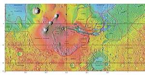
Terra Sirenum
Terra Sirenum is a large region in the southern hemisphere of the planet Mars. It is centered at 39.7°S 150°W and covers 3900 km at its broadest extent. It covers latitudes 10 to 70 South and longitudes 110 to 180 W.[1] Terra Sirenum is an upland area notable for massive cratering including the large Newton Crater. Terra Sirenum is in the Phaethontis quadrangle and the Memnonia quadrangle of Mars. A low area in Terra Sirenum is believed to have once held a lake that eventually drained through Ma'adim Vallis.[2][3][4]
Terra Sirenum is named after the Sirens, who were birds with the heads of girls. In the Odyssey these girls captured passing seamen and killed them.[5]
Chloride deposits
Evidence of deposits of chloride based minerals in Terra Sirenum was discovered by the 2001 Mars Odyssey orbiter's Thermal Emission Imaging System in March 2008. The deposits are approximately 3.5 to 3.9 billion years old. This suggests that near-surface water was widespread in early Martian history, which has implications for the possible existence of Martian life.[6][7] Besides finding chlorides, MRO discovered iron/magnesium smectites which are formed from long exposure in water.[8]
Based on chloride deposits and hydrated phyllosilicates, Alfonso Davila and others believe there is an ancient lakebed in Terra Sirenum that had an area of 30,000 km2 and was 200 meters deep. Other evidence that supports this lake are normal and inverted channels like ones found in the Atacama desert.[9]
Inverted relief
Some areas of Mars show inverted relief, where features that were once depressions, like streams, are now above the surface. It is believed that materials like large rocks were deposited in low-lying areas. Later, erosion (perhaps wind which can't move large rocks) removed much of the surface layers, but left behind the more resistant deposits. Other ways of making inverted relief might be lava flowing down a stream bed or materials being cemented by minerals dissolved in water. On Earth, materials cemented by silica are highly resistant to all kinds of erosional forces. Examples of inverted channels on Earth are found in the Cedar Mountain Formation near Green River, Utah. Inverted relief in the shape of streams are further evidence of water flowing on the Martian surface in past times.[10]
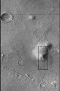
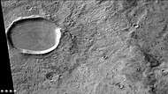
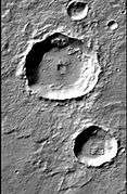 CTX image of craters with black box showing location of next image.
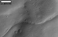 Image from previous photo of a curved ridge that may be an old stream that has become inverted. Image taken with HiRISE under the HiWish program.
Martian gullies
Terra Sirenum is the location of many Martian gullies that may be due to recent flowing water. Some are found in the Gorgonum Chaos[11][12] and in many craters near the large craters Copernicus and Newton.[13][14] Gullies occur on steep slopes, especially on the walls of craters. Gullies are believed to be relatively young because they have few, if any craters. Moreover, they lie on top of sand dunes which themselves are considered to be quite young.
 CTX image of the next image showing a wide view of the area. Since the hill is isolated it would be difficult for an aquifer to develop. Rectangle shows the approximate location of the next image.
 Gully on mound as seen by Mars Global Surveyor, under the Public Target Program. Images of gullies on isolated peaks, like this one, are difficult to explain with the theory of water coming from aquifers because aquifers need large collecting areas.
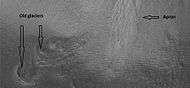 Another view of the previous gully on a mound. This one is with HiRISE, under the HiWish program. This view shows most of the apron and two old glaciers associated with it. All that is left of the glaciers are terminal moraines.
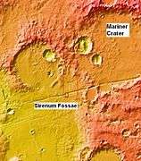 MOLA context image for the series of three images to follow of gullies in a trough and nearby crater.
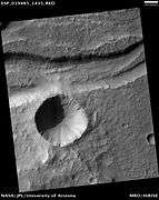 Gullies in a trough and nearby crater, as seen by HiRISE under the HiWish program. Scale bar is 500 meters long.
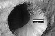 Close-up of gullies in crater, as seen by HiRISE under the HiWish program.
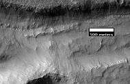 Close-up of gullies in trough, as seen by HiRISE under the HiWish program. These are some of the smaller gullies visible on Mars.
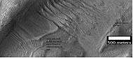 HiRISE image, taken under HiWish program, of gullies in a crater in Terra Sirenum.
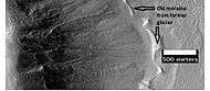 Gullies with remaines of a former glacier in crater in Terra Sirenum, as seen by HiRISE under HiWish program.
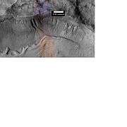 Gullies in a crater in Terra Sirenum, as seen by HiRISE under the HiWish Program.
 Close-up of gully showing multiple channels and patterned ground, as seen by HiRISE under the HiWish program.
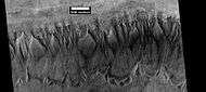 Gullies in crater in Phaethontis quadrangle, as seen by HiRISE under HiWish program
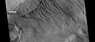 Gullies in crater, as seen by HiRISE under HiWish program. Location is Phaethontis quadrangle.
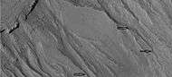 Close up of gullies in crater showing channels within larger valleys and curves in channels. These characteristics suggest they were made by flowing water. Note: this is an enlargement of the previous image by HiRISE under HiWish program. Location is Phaethontis quadrangle.
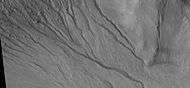 Close up of gully network showing branched channels and curves; these characteristics suggest creation by a fluid. Note: this is an enlargement of a previous wide view of gullies in a crater, as seen by HiRISE under HiWish program. Location is Phaethontis quadrangle.
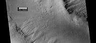 Gullies in two levels of a crater wall, as seen by HiRISE under HiWish program. Gullies at two levels suggests they were not made with an aquifer, as was first suggested. Location is Phaethontis quadrangle.
 Image of gullies with main parts labeled. The main parts of a Martian gully are alcove, channel, and apron. Since there are no craters on this gully, it is thought to be rather young. Picture was taken by HiRISE under HiWish program. Location is Phaethontis quadrangle.
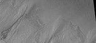 Close-up of gully aprons showing they are free of craters; hence very young. Location is Phaethontis quadrangle. Picture was taken by HiRISE under HiWish program.
Tongue-shaped glaciers
 Tongue-shaped glacier, as seen by HiRISE under the HiWish program. Location is Phaethontis quadrangle.
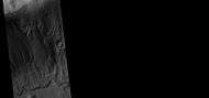 Wide view of several tongue-shaped glaciers on wall of crater, as seen by HiRISE under the HiWish program. The glaciers are of different sizes and lie at different levels. Some of these are greatly enlarged in pictures which follow.
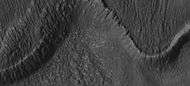 Close-up of the snouts of two glaciers from the previous image, as seen by HiRISE under the HiWish program. These are towards the bottom left of the previous image.
 Close-up of small glaciers from a previous image, as seen by HiRISE under the HiWish program. Some of these glaciers seem to be just starting to form.
 Close-up of the edge of one of the glaciers on the bottom of the wide view from a previous image Picture was taken by HiRISE under the HiWish program.
Possible pingos
The radial and concentric cracks visible here are common when forces penetrate a brittle layer, such as a rock thrown through a glass window. These particular fractures were probably created by something emerging from below the brittle Martian surface. Ice may have accumulated under the surface in a lens shape; thus making these cracked mounds. Ice being less dense than rock, pushed upwards on the surface and generated these spider web-like patterns. A similar process creates similar sized mounds in arctic tundra on Earth. Such features are called “pingos,”, an Inuit word.[15] Pingos would contain pure water ice; thus they could be sources of water for future colonists of Mars.
 Possible pingo, as seen by HiRISE under HiWish program
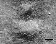 Possible pingos with scale, as seen by HiRISE under HiWish program
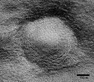 Close view of possible pingo with scale, as seen by HiRISE under HiWish program
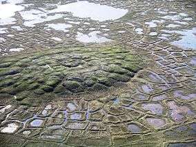 Example of a pingo on Earth. On Earth the ice that caused the pingo would melt and fill the fractures with water; on Mars the ice would turn into a gas in the thin Martian atmosphere.
Concentric crater fill
Concentric crater fill, like lobate debris aprons and lineated valley fill, is believed to be ice-rich.[16] Based on accurate topography measures of height at different points in these craters and calculations of how deep the craters should be based on their diameters, it is thought that the craters are 80% filled with mostly ice.[17][18][19][20] That is, they hold hundreds of meters of material that probably consists of ice with a few tens of meters of surface debris.[21][22] The ice accumulated in the crater from snowfall in previous climates.[23][24][25] Recent modeling suggests that concentric crater fill develops over many cycles in which snow is deposited, then moves into the crater. Once inside the crater shade and dust preserve the snow. The snow changes to ice. The many concentric lines are created by the many cycles of snow accumulation. Generally snow accumulates whenever the axial tilt reaches 35 degrees.[26]
 Crater showing concentric crater fill, as seen by CTX (on Mars Reconnaissance Orbiter). Location is Phaethontis quadrangle.
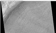 Close-up view of concentric crater fill, as seen by HiRISE under HiWish program Note: this is an enlargement of previous image of a concentric crater. Location is Phaethontis quadrangle.
 Wide view of concentric crater fill, as seen by CTX Location is the Phaethontis quadrangle.
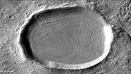 Concentric crater fill, as seen by HiRISE under HiWish program Location is the Phaethontis quadrangle.
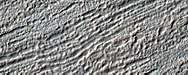 Close, color view of concentric crater fill, as seen by HiRISE under HiWish program Location is the Phaethontis quadrangle.
Liu Hsin Crater features
 Liu Hsin Crater, as seen by CTX camera (on Mars Reconnaissance Orbiter).
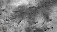 Dunes in Liu Hsin Crater, as seen by CTX camera (on Mars Reconnaissance Orbiter). Dark lines are dust devil tracks. Note: this is an enlargement of a previous image of Liu Sin Crater.
 Dust devil tracks in Liu Hsin Crater, as seen by CTX camera (on Mars Reconnaissance Orbiter). Gullies can also be seen on the crater wall, near the bottom of picture. Note: this is an enlargement of a previous image of Liu Sin Crater.
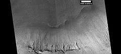 Gullies in Liu Hsin Crater, as seen by HiRISE under HiWish program. Curved lines on crater floor may be remains of old glaciers.
Magnetic stripes and plate tectonics
The Mars Global Surveyor (MGS) discovered magnetic stripes in the crust of Mars, especially in the Phaethontis and Eridania quadrangles (Terra Cimmeria and Terra Sirenum).[27][28] The magnetometer on MGS discovered 100 km wide stripes of magnetized crust running roughly parallel for up to 2000 km. These stripes alternate in polarity with the north magnetic pole of one pointing up from the surface and the north magnetic pole of the next pointing down.[29] When similar stripes were discovered on Earth in the 1960s, they were taken as evidence of plate tectonics. Researchers believe these magnetic stripes on Mars are evidence for a short, early period of plate tectonic activity. When the rocks became solid they retained the magnetism that existed at the time. A magnetic field of a planet is believed to be caused by fluid motions under the surface.[30][31][32] However, there are some differences, between the magnetic stripes on Earth and those on Mars. The Martian stripes are wider, much more strongly magnetized, and do not appear to spread out from a middle crustal spreading zone. Because the area containing the magnetic stripes is about 4 billion years old, it is believed that the global magnetic field probably lasted for only the first few hundred million years of Mars' life, when the temperature of the molten iron in the planet's core might have been high enough to mix it into a magnetic dynamo. There are no magnetic fields near large impact basins like Hellas. The shock of the impact may have erased the remnant magnetization in the rock. So, magnetism produced by early fluid motion in the core would not have existed after the impacts.[33]
When molten rock containing magnetic material, such as hematite (Fe2O3), cools and solidifies in the presence of a magnetic field, it becomes magnetized and takes on the polarity of the background field. This magnetism is lost only if the rock is subsequently heated above a particular temperature (the Curie point which is 770 °C for iron). The magnetism left in rocks is a record of the magnetic field when the rock solidified.[34]
Other features
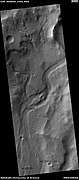 Channel, as seen by HiRISE under HiWish program Streamlined shapes are indicated with arrows. Location is the Phaethontis quadrangle.
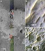 Possible chloride deposits in Terra Sirenum
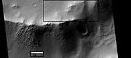 Layers in crater wall, as seen by HiRISE under HiWish program. Area in box is enlarged in the next image.
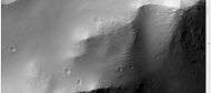 Enlargement from previous image, showing many thin layers. Note that the layers do not seem to be formed from rocks. They may be all that is left of a deposit that once filled the crater. Image was taken with HiRISE, under HiWish program.
 Surface of crater floor, as seen by HiRISE under HiWish program.
 Surface of crater floor showing details from image taken with HiRISE, under HiWish program. This may be a transition from one type of structure to a different, maybe due to erosion.
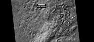 Surface showing large hollows of unknown origin, as seen by HiRISE under HiWish program. The hollows may be the result of large amounts of ice leaving the ground.
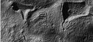 Close-up of surface with large hollows, as seen by HiRISE under HiWish program.
 Layers in mantle, as seen by HiRISE under HiWish program.
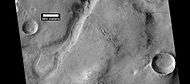 Oxbow lake, as seen by HiRISE under HiWish program.
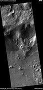
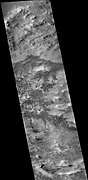
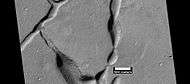 Troughs on the floor of Bernard Crater showing many boulders, as seen by HiRISE under HiWish program
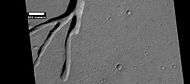 Troughs on the floor of Bernard Crater, as seen by HiRISE under HiWish program
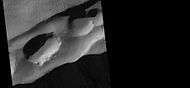 Large pits in Sirenum Fossae, as seen by HiRISE under HiWish program
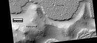 Lava flow. Lava flow stopped when it encountered the higher ground of a mound. Picture was taken with HiRISE under HiWish program.
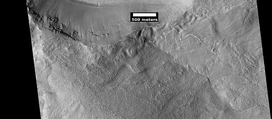 HiRISE image showing smooth mantle covering parts of a crater in the Phaethontis quadrangle. Along the outer rim of the crater, the mantle is displayed as layers. This suggests that the mantle was deposited multiple times in the past. Picture was taken with HiRISE under HiWish program. The layers are enlarged in the next image.
 Enlargement of previous image of mantle layers. Four to five layers are visible. Location is the Phaethontis quadrangle.
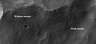 Surface showing appearance with and without mantle covering, as seen by HiRISE, under the HiWish program. Location is Terra Sirenum in Phaethontis quadrangle.
Interactive Mars map
See also
References
- http://www.itouchmap.com/?r=marsfeatures&z=7238
- Irwin, R, et al. 2002. Geomorphology of Ma'adim Vallis, Mars and associated paleolake basins. J. Geophys. Res. 109(E12): doi:10.1029/2004JE002287
- Michael H. Carr (2006). The surface of Mars. Cambridge University Press. ISBN 978-0-521-87201-0. Retrieved 21 March 2011.
- https://www.uahirise.org/ESP_050948_1430
- Blunck, J. 1982. Mars and its Satellites. Exposition Press. Smithtown, N.Y.
- Osterloo; Hamilton, VE; Bandfield, JL; Glotch, TD; Baldridge, AM; Christensen, PR; Tornabene, LL; Anderson, FS; et al. (2008). "Chloride-Bearing Materials in the Southern Highlands of Mars" (PDF). Science. 319 (5870): 1651–1654. Bibcode:2008Sci...319.1651O. doi:10.1126/science.1150690. PMID 18356522.
- "NASA Mission Finds New Clues to Guide Search for Life on Mars". 2008-03-20. Retrieved 2008-03-22.
- Murchie, S. et al. 2009. A synthesis of Martian aqueous mineralogy after 1 Mars year of observations from the Mars Reconnaissance Orbiter. Journal of Geophysical Research: 114.
- Davila, A. et al. 2011. A large sedimentary basin in the Terra Sirenum region of the southern highlands of Mars. Icarus. 212: 579-589.
- http://hirise.lpl.arizona.edu/PSP_006770_1760
- http://hirise.lpl.arizona.edu/PSP_004071_1425
- http://hirise.lpl.arizona.edu/PSP_001948_1425
- http://hirise.lpl.arizona.edu/PSP_004163_1375
- U.S. department of the Interior U.S. Geological Survey, Topographic Map of the Eastern Region of Mars M 15M 0/270 2AT, 1991
- http://www.uahirise.org/ESP_046359_1250
- Levy, J. et al. 2009. Concentric crater fill in Utopia Planitia: History and interaction between glacial "brain terrain" and periglacial processes. Icarus: 202. 462-476.
- Levy, J., J. Head, D. Marchant. 2010. Concentric Crater fill in the northern mid-latitudes of Mars: Formation process and relationships to similar landforms of glacial origin. Icarus 2009, 390-404.
- Levy, J., J. Head, J. Dickson, C. Fassett, G. Morgan, S. Schon. 2010. Identification of gully debris flow deposits in Protonilus Mensae, Mars: Characterization of a water-bearing, energetic gully-forming process. Earth Planet. Sci. Lett. 294, 368–377.
- http://hirise.lpl.arizona.edu/ESP_032569_2225
- Garvin, J., S. Sakimoto, J. Frawley. 2003. Craters on Mars: Geometric properties from gridded MOLA topography. In: Sixth International Conference on Mars. July 20–25, 2003, Pasadena, California. Abstract 3277.
- Garvin, J. et al. 2002. Global geometric properties of martian impact craters. Lunar Planet. Sci: 33. Abstract # 1255.
- http://photojournal.jpl.nasa.gov/catalog/PIA09662
- Kreslavsky, M. and J. Head. 2006. Modification of impact craters in the northern planes of Mars: Implications for the Amazonian climate history. Meteorit. Planet. Sci.: 41. 1633-1646
- Madeleine, J. et al. 2007. Exploring the northern mid-latitude glaciation with a general circulation model. In: Seventh International Conference on Mars. Abstract 3096.
- http://hirise.lpl.arizona.edu/PSP_002917_2175
- Fastook, J., J.Head. 2014. Concentric crater fill: Rates of glacial accumulation, infilling and deglaciation in the Amazonian and Noachian of Mars. 45th Lunar and Planetary Science Conference (2014) 1227.pdf
- Barlow, N. 2008. Mars: An Introduction to its Interior, Surface and Atmosphere. Cambridge University Press
- ISBN 978-0-387-48925-4
- ISBN 978-0-521-82956-4
- Connerney, J. et al. 1999. Magnetic lineations in the ancient crust of Mars. Science: 284. 794-798.
- Langlais, B. et al. 2004. Crustal magnetic field of Mars. Journal of Geophysical Research. 109: EO2008
- Connerney, J.; Acuña, MH; Ness, NF; Kletetschka, G; Mitchell, DL; Lin, RP; Reme, H; et al. (2005). "Tectonic implications of Mars crustal magnetism". Proceedings of the National Academy of Sciences of the USA. 102 (42): 14970–14975. Bibcode:2005PNAS..10214970C. doi:10.1073/pnas.0507469102. PMC 1250232. PMID 16217034.
- Acuna, M.; Connerney, JE; Ness, NF; Lin, RP; Mitchell, D; Carlson, CW; McFadden, J; Anderson, KA; et al. (1999). "Global distribution of crustal magnetization discovered by the Mars Global Surveyor MAG/ER Experiment" (PDF). Science. 284 (5415): 790–793. Bibcode:1999Sci...284..790A. doi:10.1126/science.284.5415.790. PMID 10221908.
- http://sci.esa.int/science-e/www/object/index.cfm?fobjectid=31028&fbodylongid=645
Recommended reading
- Grotzinger, J. and R. Milliken (eds.). 2012. Sedimentary Geology of Mars. SEPM.
- Lorenz, R. 2014. The Dune Whisperers. The Planetary Report: 34, 1, 8-14
- Lorenz, R., J. Zimbelman. 2014. Dune Worlds: How Windblown Sand Shapes Planetary Landscapes. Springer Praxis Books / Geophysical Sciences.
External links
| Geography | |||||||||
|---|---|---|---|---|---|---|---|---|---|
| Astronomy |
| ||||||||
| Exploration |
| ||||||||
| Related | |||||||||
| |||||||||