Ten Mile Run, New Jersey
Ten Mile Run is an unincorporated community and census-designated place (CDP) located in Franklin Township, in Somerset County, New Jersey, United States.[2][5][6][7] As of the 2010 United States Census, the CDP's population was 1,959.[4]
Ten Mile Run, New Jersey | |
|---|---|
 | |
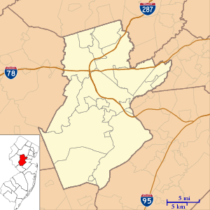 Ten Mile Run, New Jersey Location of Ten Mile Run within Somerset County. Inset: Location of Somerset County in the state of New Jersey  Ten Mile Run, New Jersey Ten Mile Run, New Jersey (New Jersey)  Ten Mile Run, New Jersey Ten Mile Run, New Jersey (the United States) | |
| Coordinates: 40.424136°N 74.586348°W[1][2] | |
| Country | United States |
| State | |
| County | Somerset |
| Township | Franklin |
| Area | |
| • Total | 2.539 sq mi (6.576 km2) |
| • Land | 2.538 sq mi (6.573 km2) |
| • Water | 0.001 sq mi (0.002 km2) 0.04% |
| Elevation | 213 ft (65 m) |
| Population | |
| • Total | 1,959 |
| • Density | 771.9/sq mi (298.0/km2) |
| Time zone | UTC-5 (Eastern (EST)) |
| • Summer (DST) | UTC-4 (Eastern (EDT)) |
| Area code(s) | 609/640 and 732/848 |
| FIPS code | 3472435[1][2] |
| GNIS feature ID | 02584033[1][2] |
Geography
According to the United States Census Bureau, Ten Mile Run had a total area of 2.539 square miles (6.576 km2), including 2.538 square miles (6.573 km2) of land and 0.001 square miles (0.002 km2) of water (0.04%).[1][2]
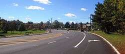
The area is named for the Ten Mile Run, a stream of the same name the hill on which it sits (part of the Rocky Hill Ridge).[8] The area is located along Route 27 (Lincoln Highway) near its intersection with County Route 518. It is located across Route 27 from South Brunswick, Middlesex County. Most of the area consists of less densely-spaced single family homes throughout and commercial establishments along Route 27. The remainder of the area is forested and hilly as the terrain descends towards the Delaware and Raritan Canal and Millstone River. Kendall Park, the CDP located on the South Brunswick side of Route 27, consists of more densely-spaced homes.[9]
Demographics
| Historical population | |||
|---|---|---|---|
| Census | Pop. | %± | |
| 2010 | 1,959 | — | |
| Population sources: 2010[4] | |||
Census 2010
The 2010 United States Census counted 1,959 people, 602 households, and 514.108 families in the CDP. The population density was 771.9 per square mile (298.0/km2). There were 622 housing units at an average density of 245.1 per square mile (94.6/km2). The racial makeup of the CDP was 31.85% (624) White, 11.94% (234) Black or African American, 0.05% (1) Native American, 50.54% (990) Asian, 0.00% (0) Pacific Islander, 2.30% (45) from other races, and 3.32% (65) from two or more races. Hispanic or Latino of any race were 6.33% (124) of the population.[4]
The 602 households accounted 49.8% with children under the age of 18 living with them; 79.6% were married couples living together; 3.8% had a female householder with no husband present, and 14.6% were non-families. Of all households, 10.1% were made up of individuals, and 3.2% had someone living alone who was 65 years of age or older. The average household size was 3.25 and the average family size was 3.53.[4]
In the CDP, the population age was spread out with 29.4% under the age of 18, 3.5% from 18 to 24, 33.9% from 25 to 44, 24.9% from 45 to 64, and 8.3% who were 65 years of age or older. The median age was 37.0 years. For every 100 females, the population had 105.3 males. For every 100 females ages 18 and older there were 103.2 males.[4]
References
- Gazetteer of New Jersey Places, United States Census Bureau. Accessed July 21, 2016.
- US Gazetteer files: 2010, 2000, and 1990, United States Census Bureau. Accessed September 4, 2014.
- U.S. Geological Survey Geographic Names Information System: Ten Mile Run Census Designated Place, Geographic Names Information System. Accessed August 23, 2012.
- DP-1 - Profile of General Population and Housing Characteristics: 2010 Demographic Profile Data for Ten Mile Run CDP, New Jersey, United States Census Bureau. Accessed February 11, 2013.
- GCT-PH1 - Population, Housing Units, Area, and Density: 2010 - County -- County Subdivision and Place from the 2010 Census Summary File 1 for Somerset County, New Jersey Archived 2020-02-12 at Archive.today, United States Census Bureau. Accessed February 11, 2013.
- 2006-2010 American Community Survey Geography for New Jersey, United States Census Bureau. Accessed February 11, 2013.
- New Jersey: 2010 - Population and Housing Unit Counts - 2010 Census of Population and Housing (CPH-2-32), United States Census Bureau, August 2012. Accessed February 11, 2013.
- Geological Survey of New Jersey. "Annual Report of the State Geologist of New Jersey." s.n., 1882
- Google (October 21, 2015). "Aerial view of Ten Mile Run (CDP)" (Map). Google Maps. Google. Retrieved October 21, 2015.
Municipalities and communities of Somerset County, New Jersey, United States | ||
|---|---|---|
| Boroughs | 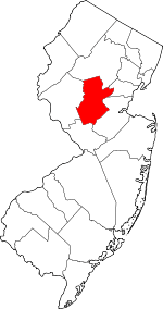 Map of New Jersey highlighting Somerset County | |
| Townships | ||
| CDPs | ||
| Other unincorporated communities | ||