Te Atatū Peninsula
Te Atatū Peninsula[2][3] (also known as Te Atatu North) is a waterfront suburb of Auckland City surrounded by the Waitemata Harbour with extensive views of the city skyline, central city and north shore. There are also direct views of the Auckland Harbour Bridge.
Te Atatū Peninsula | |
|---|---|
| |
| Country | New Zealand |
| Local authority | Auckland Council |
| Electoral ward | Waitākere Ward |
| Population (2018)[1] | |
| • Total | 13,344 |
| Royal Heights | ||
| Massey |
|
(Whau River) |
| Lincoln | Te Atatū South |
The name "Te Atatū Peninsula" was officially adopted by the New Zealand Geographic Board on 5 May 1994[4], and was formally adopted by the Waitakere Council in 1997.
Demographics
| Historical population | ||
|---|---|---|
| Year | Pop. | ±% p.a. |
| 2006 | 11,688 | — |
| 2013 | 12,486 | +0.95% |
| 2018 | 13,344 | +1.34% |
| Source: [1] | ||
Te Atatū Peninsula, comprising the statistical areas of Te Atatū Peninsula North West, Te Atatū Peninsula Central, Te Atatū Peninsula West and Te Atatū Peninsula East, had a population of 13,344 at the 2018 New Zealand census, an increase of 858 people (6.9%) since the 2013 census, and an increase of 1,656 people (14.2%) since the 2006 census. There were 4,353 households. There were 6,525 males and 6,816 females, giving a sex ratio of 0.96 males per female, with 3,120 people (23.4%) aged under 15 years, 2,361 (17.7%) aged 15 to 29, 6,339 (47.5%) aged 30 to 64, and 1,524 (11.4%) aged 65 or older.
Ethnicities were 65.0% European/Pākehā, 19.6% Māori, 14.9% Pacific peoples, 17.8% Asian, and 3.1% other ethnicities (totals add to more than 100% since people could identify with multiple ethnicities).
The proportion of people born overseas was 28.2%, compared with 27.1% nationally.
Although some people objected to giving their religion, 50.6% had no religion, 35.6% were Christian, and 8.2% had other religions.
Of those at least 15 years old, 2,802 (27.4%) people had a bachelor or higher degree, and 1,557 (15.2%) people had no formal qualifications. The employment status of those at least 15 was that 5,532 (54.1%) people were employed full-time, 1,341 (13.1%) were part-time, and 417 (4.1%) were unemployed.[1]
Location
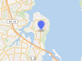
Te Atatū Peninsula is located at the western extremity of the Waitemata Harbour, and is flanked by the Henderson Creek to the west and by the Whau River to the east, both estuarial arms of the harbour, which extend southwest from the harbour itself. The relatively flat peninsula thus formed is four kilometres in length and two kilometres in width, and is joined to the main part of the North Island at its southern end. A motorway effectively cuts the peninsula off from the mainland and, with only one road in and out, the area has an almost island-like feel. Its population is closely matched by the population of Te Atatū South, the adjoining suburb.
History
Until the 1950s, Te Atatū Peninsula was mostly rural. The construction of the north-western motorway lead to development on the peninsula. During the 1960s and 1970s, Te Atatū Peninsula was covered in low- to medium-income houses.[5]
Te Atatū Peninsula was the site of the Leisureland Fun Park in the 1980s,[6] which was initially set up in collaboration with the Accident Compensation Corporation complete with a Drivertown and pleasure rides. It later became Footrot Flats Fun Park in 1985, which closed in 2000.[7]
When vacated by leisure activities, this waterfront site has been developed into medium- to high-density high-end waterfront-facing properties. The houses are popular for high-end renovations and many properties have been subdivided, increasing the population density of the suburb, as prescribed under the current Auckland Unitary Plan.
Schools
Rutherford College, named after Ernest Rutherford, is a secondary (years 9–13) school with a roll of 1344 students.[8] Te Atatū Intermediate School is for years 7–8, and has a roll of 472 students.[9]
Peninsula Primary School, Matipo Primary School and Rutherford Primary School are contributing schools (years 1–6) with rolls of 454, 444 and 374 respectively.[10][11][12]
All schools are coeducational. Rolls are as of March 2020.[13]
References
- "Statistical area 1 dataset for 2018 Census". Statistics New Zealand. March 2020. Te Atatū Peninsula North West (123200), Te Atatū Peninsula Central (124500), Te Atatū Peninsula West (124800) and Te Atatū Peninsula East (125300). 2018 Census place summary: Te Atatū Peninsula North West 2018 Census place summary: Te Atatū Peninsula Central 2018 Census place summary: Te Atatū Peninsula West 2018 Census place summary: Te Atatū Peninsula East
- "Te Atatū Peninsula Library". Auckland Council Libraries. Retrieved 21 April 2018.
- "Te Atatū Peninsula Community Centre & Library". teatatucentre.org.nz. Retrieved 21 April 2018.
- "NZGB Gazetteer | linz.govt.nz". gazetteer.linz.govt.nz. Retrieved 29 March 2020.
- McClure, Margaret (6 December 2007). "Auckland places – West Auckland". Te Ara – The Encyclopedia of New Zealand. Retrieved 2 May 2018.
- "Profiling the events that shaped our community, 1991". Local History Online. 29 July 2003. Retrieved 11 May 2018.
- "Footrot Flats Leisure Park". rcdb.com. Retrieved 11 May 2018.
- Education Counts: Rutherford College
- Education Counts: Te Atatū Intermediate School
- Education Counts: Peninsula Primary School
- Education Counts: Matipo Primary School
- Education Counts: Rutherford Primary School
- "New Zealand Schools Directory". New Zealand Ministry of Education. Retrieved 26 April 2020.
External links
- Photographs of Te Atatu Peninsula held in Auckland Libraries' heritage collections.