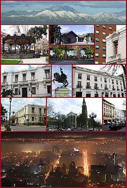
Talca
Talca (Spanish pronunciation: [ˈtalka]) is a city and commune in Chile located about 255 km (158 mi) south of Santiago, and is the capital of both Talca Province and Maule Region (7th Region of Chile). As of the 2012 census, the city had a population of 201,142.
Talca | |
|---|---|
 | |
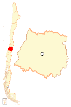
 Coat of arms 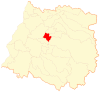 Location of Talca commune in Maule Region 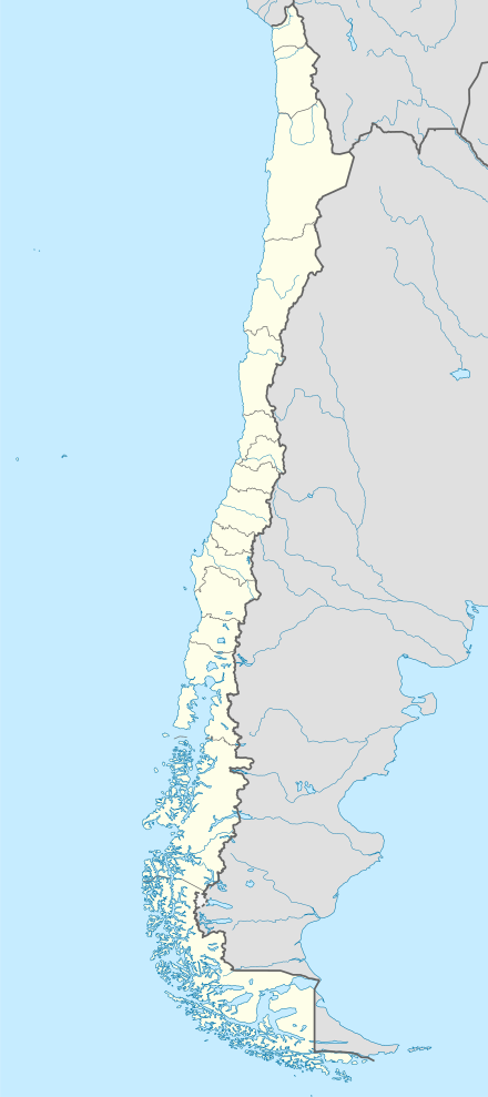 Talca Location in Chile | |
| Coordinates: 35°26′0″S 71°40′0″W | |
| Region | Maule Region |
| Province | Talca Province |
| Founded | May 12, 1742 |
| Government | |
| • Type | Municipality |
| • Alcalde | Juan Carlos Díaz Avendaño |
| Area | |
| • Total | 231.5 km2 (89.4 sq mi) |
| Elevation | 102 m (335 ft) |
| Population (2015 Census)[4] | |
| • Total | 233,339 |
| • Density | 1,000/km2 (2,600/sq mi) |
| Demonym(s) | Talquino |
| Sex | |
| • Men | 111,796 |
| • Women | 121,543 |
| Time zone | UTC−4 (CLT) |
| • Summer (DST) | UTC−3 (CLST) |
| Postal code | 3460000 |
| Area code(s) | 56 (country) + 712 (Talca Province) |
| Climate | Csb |
| Website | Official website (in Spanish) |
The city is an important economic center, with agricultural (wheat) and manufacturing activities, as well as wine production. It is also the location of the Universidad de Talca and the Catholic University of Maule, among others. The Catholic Church of Talca has held a prominent role in the history of Chile.
The inhabitants of Talca have a saying, Talca, Paris & London, born from a hat shop which had placed a ribbon stating that it had branches in Paris and London. The shop was owned by a French immigrant named Jean-Pierre Lagarde.
Demographics
According to the 2002 census of the National Statistics Institute, Talca spans an area of 231.5 km2 (89 sq mi) and had, in that year, 201,797 inhabitants. Of these, in 2002, 193,755 (96%) lived in urban areas and 8,042 (4%) in rural areas.[3] Today, the city has about 233,339 inhabitants (111,796 men and 121,543 women) according to the 2015 census. The population grew by 15.63% (31,542 persons) between the 2002 and 2015 censuses.[4]
History
The city was founded in 1692 by Tomás Marín de Poveda and refounded as Villa San Agustín de Talca in 1742 by José Antonio Manso de Velasco.[5] It was partially destroyed by the 1928 Talca earthquake and the 2010 Chile earthquake, being rebuilt both times. It sits near the epicenter of the 2010, magnitude 8.8 earthquake and suffered severe shaking[6] causing the collapse of much of the historic town centre.[7] The city played a role in Chile's independence. Here, Bernardo O'Higgins signed the Chilean independence declaration in 1818.[5]
Administration
As a commune, Talca is a third-level administrative division of Chile administered by a municipal council, headed by an alcalde who is directly elected every four years. The 2008-2012 alcalde is Juan Castro Prieto (Independent Democratic Union, centre-right).[1][2]
Within the electoral divisions of Chile, Talca is represented in the Chamber of Deputies by Sergio Aguiló (PS) and Germán Verdugo (RN) as part of the 37th electoral district, which consists entirely of the Talca commune. The commune is represented in the Senate by Juan Antonio Coloma Correa (UDI) and Andrés Zaldívar Larraín (PDC) as part of the 10th senatorial constituency (Maule-North).
Geography and climate
The commune of Talca spans an area of 231.5 km2 (89 sq mi).[3] The city of Talca is located 250 km (155 mi) south of Santiago,[5] south of the confluence of the rivers Lircay and Claro, in the Central Valley. The city is bisected by the Pan-American Highway.
Talca has a Mediterranean climate (Köppen: Csb) with dry summers and wet winters, though it is hotter in summer and cooler in winter than coastal cities like Valparaíso and Concepción.
| Climate data for Talca (1976−2005) | |||||||||||||
|---|---|---|---|---|---|---|---|---|---|---|---|---|---|
| Month | Jan | Feb | Mar | Apr | May | Jun | Jul | Aug | Sep | Oct | Nov | Dec | Year |
| Average high °C (°F) | 30.3 (86.5) |
29.5 (85.1) |
26.8 (80.2) |
21.5 (70.7) |
16.4 (61.5) |
13.4 (56.1) |
13.1 (55.6) |
15.3 (59.5) |
18.1 (64.6) |
21.6 (70.9) |
25.4 (77.7) |
28.7 (83.7) |
21.7 (71.1) |
| Daily mean °C (°F) | 21.2 (70.2) |
20.3 (68.5) |
17.4 (63.3) |
13.4 (56.1) |
10.5 (50.9) |
8.7 (47.7) |
7.9 (46.2) |
9.1 (48.4) |
11.3 (52.3) |
14.1 (57.4) |
17.1 (62.8) |
20.1 (68.2) |
14.2 (57.6) |
| Average low °C (°F) | 12.4 (54.3) |
11.9 (53.4) |
9.8 (49.6) |
7.5 (45.5) |
6.3 (43.3) |
5.1 (41.2) |
4.2 (39.6) |
4.5 (40.1) |
5.8 (42.4) |
7.6 (45.7) |
9.6 (49.3) |
11.9 (53.4) |
8.1 (46.6) |
| Average rainfall mm (inches) | 4.0 (0.16) |
3.9 (0.15) |
13.3 (0.52) |
33.8 (1.33) |
115.8 (4.56) |
146.2 (5.76) |
155.1 (6.11) |
85.9 (3.38) |
53.1 (2.09) |
34.3 (1.35) |
19.4 (0.76) |
11.5 (0.45) |
676.2 (26.62) |
| Average relative humidity (%) | 58.2 | 62.7 | 69.4 | 78.1 | 86.9 | 89.5 | 88.7 | 85.0 | 79.2 | 72.7 | 64.1 | 58.9 | 74.4 |
| Mean monthly sunshine hours | 359.6 | 288.2 | 263.5 | 168.0 | 105.4 | 75.0 | 93.0 | 145.7 | 183.0 | 248.0 | 300.0 | 337.9 | 2,567.3 |
| Source: University de Talca[8] | |||||||||||||
Transportation
There is some kind of public transport by private owned busses.
Gallery
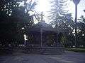 A garden pavilion in Plaza de Armas (Armas Square)
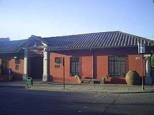 O'Higginian Historical Museum (Museo Histórico O'Higginiano)
 Calle Sur de Talca (Talca Southern Street)
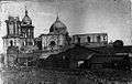 Aftermath in damage at Talca Cathedral, by 1928 Talca earthquake
See also
- Maule River
- Descabezado Grande
- Radal Siete Tazas National Reserve
- Altos de Lircay National Reserve
- Juan Albano Pereira Márquez
References
- "Municipality of Talca" (in Spanish). Retrieved 22 January 2010.
- "Asociación Chilena de Municipalidades" (in Spanish). Archived from the original on 19 April 2011. Retrieved 22 January 2010.
- "National Statistics Institute" (in Spanish). Retrieved 28 July 2010.
- "National Statistics Institute" (in Spanish). Retrieved 28 April 2017.
- "Maule Region". Universidad de Talca. Archived from the original on 2008-03-14. Retrieved 2008-07-30.
- Intensity of shaking in cities around the 2010 Chilean earthquake from USGS Archived 2016-01-13 at the Wayback Machine
- Images of earthquake including collapse of Talca historic centre
- "Resumen de datos meteorológicos de Talca" (in Spanish). University of Talca. Retrieved November 21, 2014.
External links
| Wikimedia Commons has media related to: |
- (in Spanish) Municipality of Talca
- Urban Umbrella Architectural Exhibition
- Talca's Gate
- El aMaule
- La Prensa
- El Centro
- WWW.DELMAULE.CL
| Authority control |
|
|---|