Tabanan Regency
Tabanan is a regency (kabupaten) of Bali, Indonesia. It has an area of 839.33 km2 and population of 386,850 (2000), rising to 420,913 in 2010 Census.[1] Its regency seat is Tabanan. Tanah Lot is in Tabanan.
Tabanan Regency Kabupaten Tabananᬓᬩᬸᬧᬢᬾᬦ᭄ᬢᬩᬦᬦ᭄ | |
|---|---|
 Seal | |
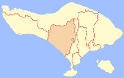 Location of Tabanan | |
| Coordinates: 8°33′4.13″S 115°7′17.81″E | |
| Country | |
| Province | |
| Capital | Tabanan |
| Area | |
| • Total | 839.33 km2 (324.07 sq mi) |
| Population (2010) | |
| • Total | 420,913 |
| • Density | 500/km2 (1,300/sq mi) |
| Time zone | UTC+8 (WITA) |
| Area code(s) | +62 361 |
| Website | tabanankab.go.id |
Districts
The regency is divided into ten districts, listed below with their 2010 Census populations:[2]
- Selemadeg 19,262
- Selemadeg Timur (East Selemadeg) 21,154
- Selemadeg Barat (West Selemadeg) 18,809
- Kerambitan 37,704
- Tabanan district 70,526
- Kediri, Bali 84,215
- Marga 40,353
- Baturiti 46,425
- Penebel 44,104
- Pupuan 38,361
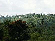
Jatiluwih

Jatiluwih village in Penebel District, north of Tabanan, has paddy fields following the contours of terraced land against the background of spellbinding Mount Batukaru and Mount Agung use traditional Balinese irrigation known as subak, Bali's community-based water control management system. Lies at an altitude of 700 meters, the cool atmosphere of more original beautiful Jatiluwih is better than the most well known Tegallalang which has plenty of cafes and souvenir shops. Two routes to Jatiluwih are Denpasar>Kediri>Tabanan>Penebel>Jatiluwih or Denpasar>Mengwi>Baturiti>Jatiluwih.[3] Jatiluwih is one of the five rice terraces that describe the "Subak" water management system which has gain acknowledgement from UNESCO as part of the world's cultural heritage.[4]
Tourism development control
To preserve the largest area of 53,000 hectares agriculture fields on the island, Tabanan Regency Administration would not allow the development of star-rated and city hotels anymore, unless tourism facilities with a commitment to environmental conservation would be allowed with 30 percent of buildings and 70 percent had to be left naturally as paddy field or plantation. The administration has also decided 300-hectare protected paddy field zone with a 100-hectare housing zone lies outside the protected zone. For visitors it is possible to visit the 300-hectare on foot (about 3,5 hr trekking) or alternatively with an e-bike tour that the local villagers organize since 2017 (about 1 h).
References
- "Archived copy". Archived from the original on 2012-06-28. Retrieved 2012-03-25.CS1 maint: archived copy as title (link)
- Biro Pusat Statistik, Jakarta, 2011.
- http://www.thejakartapost.com/news/2011/06/05/jatiluwih’s-beautiful-terraced-rice-fields.html
- https://whc.unesco.org/en/list/1194
External links
![]()
| Wikimedia Commons has media related to Tabanan Regency. |
- (in Indonesian) Official site