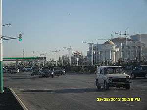
Türkmenabat
Türkmenabat (Turkmen: Türkmenabat, Түркменабат), formerly and since medieval times, Chardzhou (Russian: Чарджоу, Chardzhou; Turkmen: Çärjew, Чәрҗев)[lower-alpha 1] (Persian: چهارجوی 'čahârjuy', meaning 'four brooks') and in ancient times Āmul, is the second-largest city in Turkmenistan and the capital of Lebap Province. As of 2009, it had a population of approximately 254,000 people (up from 161,000 in the 1989 census).
Türkmenabat Түркменабат | |
|---|---|
 | |
 Seal | |
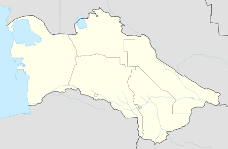 Türkmenabat Location in Turkmenistan | |
| Coordinates: 39°05′N 63°34′E | |
| Country | |
| Province | Lebap Province |
| Elevation | 187 m (614 ft) |
| Population (2009 census)[1] | |
| • Total | 253,000 |

Etymology
The former name of the city, Çärjew, is a Turkmen borrowing from the Persian term, čahârjuy, which is consisted of two parts: 'čahâr', meaning 'four' and 'juy' meaning 'brook'.
This type of naming is also common in Iran, like the village Se Juy (literally 'three brooks').
Geography
Türkmenabat is located at an altitude of 187 m (614 ft) on the banks of the Amu Darya River, near the border with Uzbekistan. Türkmenabat is at the center of Lebap province, which has borders with three provinces in Turkmenistan: Mary, Ahal and Daşoguz. The province also borders with Uzbekistan and Afghanistan.
Some 70 kilometres (43 miles) south of Türkmenabat in the East Karakum Desert is the Repetek Nature Reserve, famed for its zemzen, or desert crocodiles.
History
Although now a modern industrial city, Türkmenabat has a history of over 2,000 years. In ancient times, it was known as Āmul (to be distinguished from the Iranian city of Amol). The river Amu Darya is said to mean River of Āmul, named after this ancient city. Türkmenabat was the hub in an intersection between 3 paths of the Great Silk Way leading to Bukhara, Khiva and Merv. . For centuries, Āmul was an important town of the relatively backward Uzbek feudal khanate (later emirate) of Bukhara.
When the Russian Empire started annexing Central Asian Turkestan, Āmul was surrendered to Russians by the Bukhara emirate, who later herself would entirely become a vassal of Russia and pledge allegiance to the Russian emperor. The modern city was founded in 1886, when Cossack Russians settled in Uralka in what is now the eastern part of Türkmenabat, naming their settlement New-Chardjuy. The settlement here was necessary to complete the construction of the Trans-Caspian railway.
After the revolution of 1917, when the Bolsheviks came into power in Russia, communists merged former khanates into republics on the basis of nationality. Thus, Türkmenabat (known as Chardjuy at those times) was passed to the newly created Turkmen Soviet Socialist Republic in order to reduce the territory and strength of a highly nationalistic Uzbekistan.
Its role as a railway junction, and the high fertility of the Amu Darya region, made it the major trade center for agricultural products in the northeast region of the country. The city has food processing, textile (cotton processing and silk) factories. Chardzhou was Turkmenistan's industrial and transport hub during the Soviet period, but most of these related jobs and transport opportunities have been relocated to Ashgabat or closed since Turkmenistan's independence.
From the article about Chardjuy in Brockhaus and Efron Encyclopedic Dictionary (beginning of the 20th century):
Chardjuy is an urban settlement formed near the Amu-Darya station (1070 c. from Krasnovodsk) of the Central Asian Railway, on the left bank of the Amu-Darya River, on land ceded by the emir of Bukhara to the Russian government. There are 4 068 inhabitants (2 651 men, 1 417 women), including 3 501 Russians. There are wide straight streets, enough greenery, lots of shops, and a rather lively bazaar. Chardjuy is an important trade center, where goods going to Bukhara, Khiva, and partly to Afghanistan, are loaded onto river vessels. The steamboat of the Amu Darya fleet maintains communication between Patta Gissar (Termez) in the south and Petro-Aleksandrovsky (Khiva)... At 16 verst from Chardjuy lies the rather large Bukharan city of Chardjuy (native Chardjuy), the center of Chardjuy province (bekstvo), with the remains of walls and a fortress; 15 thousand inhabitants. Old Chardjuy (Amu-Darya) is characterized by a lively trade exchange. In 1900, 1820244 pd arrived at the station. (military supplies, sugar, timber, building material, iron, flour, tea, rice, etc.); Sent from the Chardjuy station in the same year: 963382 (leather, carpets, sheepskin, cotton seed, cotton - 516641 pd, wool, etc.).
Climate
Türkmenabat has a cool desert climate (Köppen climate classification BWk), with cool winters and very hot summers. Rainfall is generally light and erratic, and occurs mainly in the winter and spring months.
| Climate data for Türkmenabat | |||||||||||||
|---|---|---|---|---|---|---|---|---|---|---|---|---|---|
| Month | Jan | Feb | Mar | Apr | May | Jun | Jul | Aug | Sep | Oct | Nov | Dec | Year |
| Record high °C (°F) | 24.0 (75.2) |
28.4 (83.1) |
33.9 (93.0) |
40.3 (104.5) |
42.2 (108.0) |
44.0 (111.2) |
44.9 (112.8) |
43.0 (109.4) |
40.4 (104.7) |
35.6 (96.1) |
31.3 (88.3) |
25.7 (78.3) |
44.9 (112.8) |
| Average high °C (°F) | 6.8 (44.2) |
10.0 (50.0) |
16.0 (60.8) |
24.4 (75.9) |
30.4 (86.7) |
34.8 (94.6) |
36.4 (97.5) |
34.5 (94.1) |
29.7 (85.5) |
22.6 (72.7) |
15.0 (59.0) |
8.3 (46.9) |
22.4 (72.3) |
| Daily mean °C (°F) | 1.0 (33.8) |
3.7 (38.7) |
9.2 (48.6) |
17.1 (62.8) |
23.3 (73.9) |
27.6 (81.7) |
29.3 (84.7) |
26.9 (80.4) |
21.2 (70.2) |
13.9 (57.0) |
7.6 (45.7) |
2.7 (36.9) |
15.3 (59.5) |
| Average low °C (°F) | −3.3 (26.1) |
−1.1 (30.0) |
3.6 (38.5) |
10.4 (50.7) |
15.7 (60.3) |
19.5 (67.1) |
21.4 (70.5) |
19.0 (66.2) |
13.1 (55.6) |
6.6 (43.9) |
1.7 (35.1) |
−1.8 (28.8) |
8.7 (47.7) |
| Record low °C (°F) | −23.8 (−10.8) |
−22.2 (−8.0) |
−16.3 (2.7) |
−4.6 (23.7) |
0.8 (33.4) |
9.4 (48.9) |
11.2 (52.2) |
9.1 (48.4) |
2.8 (37.0) |
−9.5 (14.9) |
−19.8 (−3.6) |
−23.4 (−10.1) |
−23.8 (−10.8) |
| Average precipitation mm (inches) | 19 (0.7) |
17.4 (0.69) |
26.7 (1.05) |
22.4 (0.88) |
10.4 (0.41) |
1.5 (0.06) |
1.0 (0.04) |
0.1 (0.00) |
0.5 (0.02) |
4.6 (0.18) |
9.8 (0.39) |
16.1 (0.63) |
129.5 (5.05) |
| Average precipitation days (≥ 0.1 mm) | 6.3 | 5.8 | 5.6 | 4.7 | 2.0 | 0.5 | 0.2 | 0.3 | 0.2 | 1.5 | 5.2 | 6.3 | 38.6 |
| Average relative humidity (%) | 76.9 | 69.6 | 59.4 | 51.4 | 43.1 | 36.0 | 37.4 | 38.1 | 43.3 | 54.4 | 69.3 | 77.2 | 54.7 |
| Mean monthly sunshine hours | 131.8 | 153.2 | 197.6 | 242.1 | 330.3 | 384.5 | 395.3 | 379.1 | 322.7 | 267.7 | 193.7 | 132.0 | 3,130 |
| Source 1: climatebase.ru[2] | |||||||||||||
| Source 2: NOAA (1961-1990)[3] | |||||||||||||
Demographics
Türkmenabat is unusual in Turkmenistan because it has population which speaks its own dialect. This regional dialect mostly consist of Turkmen language and Uzbek language which has heavily influenced the area's culture and customs. This dialect is mostly spoken in Turkmenabat and Northern provinces of Lebap.
Transport
Türkmenabat is connected with the Turkmen capital Ashgabat and Turkmen port city Türkmenbaşy by Turkmenistan Airlines and the M37 highway. Türkmenabat is also connected by train to every province in Turkmenistan.
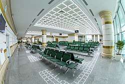
A new terminal of Turkmenabat International Airport opened in 2018. The capacity of the airport complex is 500 passengers per hour. Türkmenabat offers air service to and from all the major cities of the Turkmenistan, as well as some destinations to Moscow and Bokhtar.
Culture
Tasinlikler meydanchasy is a park where people celebrate national holidays.
Türkmenabat also well known for its bazaars.[4] The largest bazaar is "World bazaar" which is known by the name Dunya bazar. Other well-known bazaars are Gok bazar and Merkezi bazar. People from all around the country come to Türkmenabat in order to purchase local, Chinese, Turkish, Uzbek and Russian goods. Dunya bazar has many sections, including those for jewelry, home appliances, clothes, diary, cars, and other items.
One of the most attractive places in Türkmenabat is Zaton, is an artificial beach, located about 5 kilometres (3.1 mi) from the center of the city. During the whole summer youth gather at 'Zaton' for relaxation and enjoyment.
Education
Türkmenabat has one state-owned University specializing in teacher training (known in Turkmen as: Seýitnazar Seýdi adyndaky Türkmen Döwlet Mugallymçylyk Instituty'), a medical college, carrier schools, public schools, and specialised arts and sports schools. Until recently, there was a Tutkmenabat Turkmen-Turkish High School which was part of the countrywide network of Turkmen-Turkish schools, and one of the leading schools in the city. It followed a national educational curriculum, where students have a good opportunity to learn English as well as Turkish and Russian languages. Students of this school have attended international Olympiads and gained many medals in different branches of Science and Technology. Students of Turkmen-Turkish Schools are honored as 'Pride of Nation'. As a result of recent changes in education policy, Turkmen-Turkish school in Türkmenabat was turned into a specialised boarding school.
References
- Footnotes
- Also spelled Chardjui, Charjou, Chardzhev, Charjev Chärjew, or Charjew
- Notes
- Population census 1989 Archived 2012-01-18 at the Wayback Machine, Demoscope Weekly, No. 359-360, 1–18 January 2009 (search for Туркменская ССР) (in Russian)
- "Chardzhou, Turkmenistan". Climatebase.ru. Retrieved 9 February 2013.
- "Climate Normals for Charjew". National Oceanic and Atmospheric Administration. Retrieved 9 February 2013.
- Vadim Ismakaev. "Türkmenabat". Retrieved 7 November 2017.
External links
| Wikimedia Commons has media related to Türkmenabat. |
| Wikivoyage has a travel guide for Türkmenabat. |
Capital: Ashgabat | |