Summit Township, Marion County, Kansas
Summit Township is a township in Marion County, Kansas, United States. As of the 2010 census, the township population was 80.[1]
Summit Township Marion County, Kansas | |
|---|---|
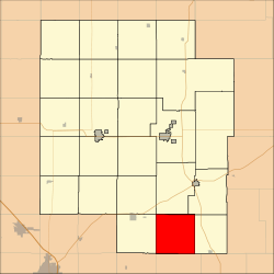 Location within Marion County | |
 Summit Township Marion County, Kansas Location within the state of Kansas | |
| Coordinates: 38°7′21″N 096°58′54″W | |
| Country | United States |
| State | Kansas |
| County | Marion |
| Area | |
| • Total | 36 sq mi (90 km2) |
| Dimensions | |
| • Length | 6.0 mi (9.7 km) |
| • Width | 6.0 mi (9.7 km) |
| Elevation | 1,463 ft (446 m) |
| Population | |
| • Total | 80 |
| • Density | 2.2/sq mi (0.86/km2) |
| Time zone | UTC−06:00 (CST) |
| • Summer (DST) | UTC−05:00 (CDT) |
| Area code | 620 |
| FIPS code | 20-69100 [2] |
| GNIS feature ID | 477782 [3] |
| Website | County Website |
Geography
Summit Township covers an area of 36 square miles (93.2 km2).
Communities
The township contains the following settlements:
- Ghost town of Watchorn. It was a former oil boom community during the 1910s and 1920s. It is located at the corner of Timber Rd and 60th St.
Cemeteries
The township contains the following cemeteries:[4]
- Summit Township Cemetery (a.k.a. United Brethren Cemetery), located in Section 23 T22S R4E. The church was closed and demolished in the 2010s.
- Whitewater Center Cemetery (a.k.a. Stone Church Cemetery), located in Section 28 T22S R4E. The church is across the road.
Gallery
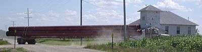
Truck hauling 36-Inch pipe to build Keystone-Cushing Pipeline (Phase II) south-east of Peabody at corner of Timber Rd and 20th St in Marion County. (Whitewater Center Church in background), in 2010.
Further reading
References
- "2010 Total Population - Township of Summit". U.S. Census Bureau. Archived from the original on February 12, 2020. Retrieved June 15, 2013.
- "U.S. Census website". United States Census Bureau. Retrieved 2011-05-14.
- U.S. Geological Survey Geographic Names Information System: Township of Summit
- Marion County Cemetery List; KsGenWeb. (archived on archive.org)
External links
- Marion County Website
- City-Data.com
- Marion County Maps: Current, Historic, KDOT
Places adjacent to Summit Township, Marion County, Kansas | |
|---|---|
Municipalities and communities of Marion County, Kansas, United States | ||
|---|---|---|
| Cities | 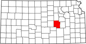 Map of Kansas highlighting Marion County | |
| Unincorporated communities | ||
| Ghost towns | ||
| Townships | ||
| Footnotes | ‡This populated place also has portions in an adjacent county or counties | |
This article is issued from Wikipedia. The text is licensed under Creative Commons - Attribution - Sharealike. Additional terms may apply for the media files.